TopoQuest Logo
Do you find TopoQuest useful?
Help keep TopoQuest running and adding new maps/features by donating!
Bitcoin:  19c7KJd3qBynnjoSw5npx9KScwjBe4ifkT
Litecoin:  LXs6TkuXGGXo1vDsWCkWVdjQX94eUKd6ui
Home View Maps Find Maps Find Places Resources & Links


Lake Sinclair West, Georgia Topographic Map

USGS Map Title: Lake Sinclair West, GA
USGS Map MRC: 33083B3
DRG (GeoTIFF) Download: o33083b3.tif


Neighboring USGS Topographic Map Quads:


  Eatonton, GA  
33083C4
 

  Meda, GA  
33083C3
 

  Rockville, GA  
33083C2
 

  Resseaus Crossroads, GA  
33083B4
 

  Lake Sinclair West, GA  
33083B3
 

  Lake Sinclair East, GA  
33083B2
 

  Haddock, GA  
33083A4
 

  Browns Crossing, GA  
33083A3
 

  Milledgeville, GA  
33083A2


Map MRC Location:

N34°
W84°
N34°
W83°
H8 H7 H6 H5 H4 H3 H2 H1
G8 G7 G6 G5 G4 G3 G2 G1
F8 F7 F6 F5 F4 F3 F2 F1
E8 E7 E6 E5 E4 E3 E2 E1
D8 D7 D6 D5 D4 D3 D2 D1
C8 C7 C6 C5 C4 C3 C2 C1
B8 B7 B6 B5 B4 B3 B2 B1
A8 A7 A6 A5 A4 A3 A2 A1
N33°
W84°
N33°
W83°

Lake Sinclair West, GA USGS 1:24K Topographic Map Preview:
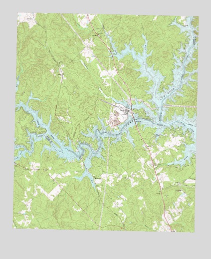
Lake Sinclair West, GA USGS Topographic Map
Click on map above to begin viewing in our Map Viewer.

This topographic map contains these locations and features:
Feature Name Type Latitude Longitude GNIS ID View Map
Baldwin County Fire and Rescue Department Station 6BuildingN33.1539°W83.3466°2604278View Map
Baldwin County Fire and Rescue Department Station 7BuildingN33.1521°W83.2597°2604277View Map
Baldwin Memorial GardensCemeteryN33.1643°W83.2802°310754View Map
Beaverdam CreekStreamN33.1890°W83.2788°310995View Map
Bethel ChurchChurchN33.1599°W83.3529°311190View Map
Buck CreekStreamN33.1276°W83.3013°311952View Map
Cedar CreekStreamN33.1793°W83.3540°310338View Map
Cold BranchStreamN33.2246°W83.2871°312810View Map
Deerfield LandingAirportN33.2193°W83.3169°2646202View Map
DennisPopulated PlaceN33.2143°W83.3424°355478View Map
Dennis Grove School (historical)SchoolN33.1946°W83.3110°347197View Map
Fellowship ChurchChurchN33.1501°W83.2735°345268View Map
Flat RockPopulated PlaceN33.2374°W83.3174°331726View Map
HallwoodPopulated PlaceN33.2471°W83.3632°356148View Map
Harllee Branch Power PlantBuildingN33.1946°W83.2979°347211View Map
Howe CemeteryCemeteryN33.1590°W83.3121°345287View Map
Humbers Old Ferry (historical)CrossingN33.1749°W83.3277°347217View Map
Jackson Family GraveyardCemeteryN33.2021°W83.2524°1985822View Map
John Milledge Academy Christian SchoolSchoolN33.1485°W83.2598°316136View Map
John Milledge Academy DamDamN33.1485°W83.2582°340629View Map
John Milledge Academy LakeReservoirN33.1468°W83.2586°340630View Map
Lakeside ChurchChurchN33.2443°W83.2596°316576View Map
Little CreekStreamN33.2418°W83.3143°317017View Map
Little RiverStreamN33.1876°W83.2740°356366View Map
MeriwetherPopulated PlaceN33.1551°W83.3190°326395View Map
Mount Ararat ChurchChurchN33.2221°W83.3446°318557View Map
Mount Ararat School (historical)SchoolN33.2224°W83.3457°347235View Map
NonaPopulated PlaceN33.2199°W83.3460°347240View Map
Potato CreekStreamN33.1704°W83.3668°329313View Map
Putnam County Fire Department Station 2BuildingN33.2392°W83.3116°2604633View Map
Putnam County Fire Rescue Department Station 4BuildingN33.2028°W83.3741°2604606View Map
Rock Mill ChurchChurchN33.1476°W83.2740°321744View Map
Rooty CreekStreamN33.1982°W83.2738°329519View Map
Rooty Creek ChurchChurchN33.2382°W83.3171°321895View Map
Saint Marys ChurchChurchN33.1599°W83.3671°322202View Map
Saint Pauls ChurchChurchN33.1551°W83.2974°322273View Map
Sinclair ChurchChurchN33.1535°W83.2610°323029View Map

Note: Coordinates in the location and feature list above are referenced to NAD83 datum.


Copyright (C) 2008-2024 Ryan Niemi / Sunset Dynamics ... All Rights Reserved