TopoQuest Logo
Do you find TopoQuest useful?
Help keep TopoQuest running and adding new maps/features by donating!
Bitcoin:  19c7KJd3qBynnjoSw5npx9KScwjBe4ifkT
Litecoin:  LXs6TkuXGGXo1vDsWCkWVdjQX94eUKd6ui
Home View Maps Find Maps Find Places Resources & Links


Lake George, Colorado Topographic Map

USGS Map Title: Lake George, CO
USGS Map MRC: 38105H3
DRG (GeoTIFF) Download: o38105h3.tif


Neighboring USGS Topographic Map Quads:


  Tarryall, CO  
39105A4
 

  Hackett Mountain, CO  
39105A3
 

  Signal Butte, CO  
39105A2
 

  Elevenmile Canyon, CO  
38105H4
 

  Lake George, CO  
38105H3
 

  Divide, CO  
38105H2
 

  Witcher Mountain, CO  
38105G4
 

  Wrights Reservoir, CO  
38105G3
 

  Cripple Creek North, CO  
38105G2


Map MRC Location:

N39°
W106°
N39°
W105°
H8 H7 H6 H5 H4 H3 H2 H1
G8 G7 G6 G5 G4 G3 G2 G1
F8 F7 F6 F5 F4 F3 F2 F1
E8 E7 E6 E5 E4 E3 E2 E1
D8 D7 D6 D5 D4 D3 D2 D1
C8 C7 C6 C5 C4 C3 C2 C1
B8 B7 B6 B5 B4 B3 B2 B1
A8 A7 A6 A5 A4 A3 A2 A1
N38°
W106°
N38°
W105°

Lake George, CO USGS 1:24K Topographic Map Preview:
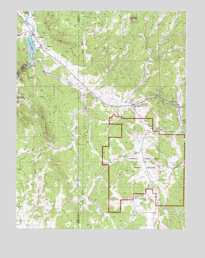
Lake George, CO USGS Topographic Map
Click on map above to begin viewing in our Map Viewer.

This topographic map contains these locations and features:
Feature Name Type Latitude Longitude GNIS ID View Map
Adamans CreekStreamN38.9889°W105.3633°191120View Map
Arkansas GulchValleyN38.9874°W105.3675°183820View Map
Bentleon RanchLocaleN38.9617°W105.3136°191150View Map
Big Spring RanchLocaleN38.9033°W105.3289°191153View Map
Blue Bird MineMineN38.9583°W105.3583°1745942View Map
Blue MountainSummitN38.9300°W105.3536°191143View Map
Blue Mountain CampgroundLocaleN38.9614°W105.3619°196742View Map
Blue Mountain RanchLocaleN38.9278°W105.3328°191152View Map
Crystal PeakSummitN38.9958°W105.2892°191148View Map
Crystal Peak RanchLocaleN38.9592°W105.3255°191151View Map
Elevenmile CanyonValleyN38.9686°W105.3652°191118View Map
Fish CreekStreamN38.9553°W105.3239°191154View Map
FlorissantPopulated PlaceN38.9458°W105.2894°191155View Map
Florissant CemeteryCemeteryN38.9325°W105.2730°191157View Map
Florissant Census Designated PlaceCensusN38.9446°W105.2899°2583235View Map
Florissant Fire and Rescue Station 1BuildingN38.9450°W105.2931°2667130View Map
Florissant Fire and Rescue Station 2BuildingN38.8879°W105.2705°2666960View Map
Florissant Fossil Beds National MonumentParkN38.9126°W105.2803°191398View Map
Florissant Post OfficePost OfficeN38.9446°W105.2878°2759195View Map
Grape CreekStreamN38.9461°W105.2983°191156View Map
Joe Wilson Recreation DamDamN38.9433°W105.3255°198846View Map
Joe Wilson Recreation ReservoirReservoirN38.9442°W105.3244°198847View Map
Lake GeorgeReservoirN38.9787°W105.3641°204767View Map
Lake GeorgePopulated PlaceN38.9797°W105.3575°191146View Map
Lake George CemeteryCemeteryN38.9980°W105.3672°191147View Map
Lake George DamDamN38.9817°W105.3672°198848View Map
Lake George Fire Protection District Station 1BuildingN38.9890°W105.3670°2667350View Map
Lake George Forest Service StationLocaleN38.9794°W105.3530°196744View Map
Lake George Post OfficePost OfficeN38.9817°W105.3593°2759202View Map
Magnuson Number 1 DamDamN38.8833°W105.2522°198854View Map
Magnuson Reservoir Number 1ReservoirN38.8833°W105.2522°198855View Map
N Snare RanchLocaleN38.8933°W105.2778°191145View Map
Park County Sheriff's Office Lake George SubstationBuildingN38.9721°W105.3449°2696660View Map
Pulver GulchValleyN38.9955°W105.3680°183806View Map
Riverside CampgroundLocaleN38.9603°W105.3739°196743View Map
Sanborn Western CampLocaleN38.9025°W105.3292°196746View Map
Signal Rock RanchLocaleN38.9617°W105.2547°191149View Map
Teller Pegmatite MineMineN38.9583°W105.3700°1745943View Map
Teller Pegmatite MineMineN38.9697°W105.3619°1735429View Map
Twin CreekStreamN38.9719°W105.3639°191144View Map

Note: Coordinates in the location and feature list above are referenced to NAD83 datum.


Copyright (C) 2008-2024 Ryan Niemi / Sunset Dynamics ... All Rights Reserved