TopoQuest Logo
Do you find TopoQuest useful?
Help keep TopoQuest running and adding new maps/features by donating!
Bitcoin:  19c7KJd3qBynnjoSw5npx9KScwjBe4ifkT
Litecoin:  LXs6TkuXGGXo1vDsWCkWVdjQX94eUKd6ui
Home View Maps Find Maps Find Places Resources & Links


Lagrange, Ohio Topographic Map

USGS Map Title: Lagrange, OH
USGS Map MRC: 41082B1
DRG (GeoTIFF) Download: o41082b1.tif


Neighboring USGS Topographic Map Quads:


  Oberlin, OH  
41082C2
 

  Grafton, OH  
41082C1
 

  West View, OH  
41081C8
 

  Wellington, OH  
41082B2
 

  Lagrange, OH  
41082B1
 

  Mallet Creek, OH  
41081B8
 

  Sullivan, OH  
41082A2
 

  Lodi, OH  
41082A1
 

  Westfield Center, OH  
41081A8


Map MRC Location:

N42°
W83°
N42°
W82°
H8 H7 H6 H5 H4 H3 H2 H1
G8 G7 G6 G5 G4 G3 G2 G1
F8 F7 F6 F5 F4 F3 F2 F1
E8 E7 E6 E5 E4 E3 E2 E1
D8 D7 D6 D5 D4 D3 D2 D1
C8 C7 C6 C5 C4 C3 C2 C1
B8 B7 B6 B5 B4 B3 B2 B1
A8 A7 A6 A5 A4 A3 A2 A1
N41°
W83°
N41°
W82°

Lagrange, OH USGS 1:24K Topographic Map Preview:
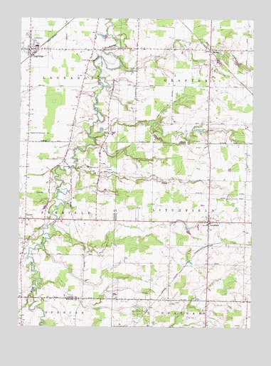
Lagrange, OH USGS Topographic Map
Click on map above to begin viewing in our Map Viewer.

This topographic map contains these locations and features:
Feature Name Type Latitude Longitude GNIS ID View Map
Aldrich CemeteryCemeteryN41.2378°W82.0660°1037354View Map
BeldenPopulated PlaceN41.2381°W82.0232°1048510View Map
Belden CemeteryCemeteryN41.2373°W82.0185°1963547View Map
Belden Post Office (historical)Post OfficeN41.2376°W82.0235°2026620View Map
Blue Barn FarmsLocaleN41.2097°W82.0417°2704637View Map
Center CreekStreamN41.1623°W82.1088°1067448View Map
Conrad FarmsLocaleN41.1906°W82.1014°2706143View Map
Crow CreekStreamN41.1892°W82.0954°1039500View Map
Eppley PondReservoirN41.2283°W82.0649°1077800View Map
Eppley Pond DamDamN41.2284°W82.0649°1077799View Map
Grafton Township Fire and RescueBuildingN41.2359°W82.0224°2549778View Map
Grafton Township HallBuildingN41.2362°W82.0226°1059052View Map
Harris Corn Field AirportAirportN41.1719°W82.0594°1082793View Map
Keystone High SchoolSchoolN41.2387°W82.1165°1059054View Map
Keystone Middle SchoolSchoolN41.2387°W82.1154°1059053View Map
Knowles CemeteryCemeteryN41.2332°W82.0876°1042328View Map
Kruggel AirportAirportN41.1433°W82.0246°1082794View Map
Kruggel FarmsLocaleN41.1453°W82.0250°2630678View Map
LagrangePopulated PlaceN41.2373°W82.1199°1064961View Map
Lagrange AirportAirportN41.2028°W82.1189°1082775View Map
Lagrange Fire and RescueBuildingN41.2381°W82.1202°2549775View Map
LaGrange Police DepartmentBuildingN41.2304°W82.1205°2732722View Map
Lagrange Post OfficePost OfficeN41.2376°W82.1193°2026552View Map
Lagrange Township HallBuildingN41.2376°W82.1232°1059055View Map
LitchfieldPopulated PlaceN41.1678°W82.0229°1065007View Map
Litchfield Center CemeteryCemeteryN41.1687°W82.0179°1963491View Map
Litchfield Elementary SchoolSchoolN41.1667°W82.0238°1058858View Map
Litchfield Fire DepartmentBuildingN41.1686°W82.0317°2550026View Map
Litchfield Post OfficePost OfficeN41.1681°W82.0235°2036156View Map
PenfieldPopulated PlaceN41.1687°W82.1213°1044365View Map
Penfield CemeteryCemeteryN41.1678°W82.1088°1044366View Map
Penfield Community ChurchChurchN41.1689°W82.1207°1807555View Map
Penfield Community ParkParkN41.1681°W82.1232°1059057View Map
Penfield Elementary SchoolSchoolN41.1681°W82.1196°1059058View Map
Penfield Post Office (historical)Post OfficeN41.1681°W82.1207°2026409View Map
Penfield Township HallBuildingN41.1687°W82.1232°1059056View Map
Preston Oil FieldOilfieldN41.1314°W82.0599°1058857View Map
Risley (historical)Populated PlaceN41.1362°W82.0443°1058856View Map
Salt CreekStreamN41.2309°W82.0713°1045909View Map
Township of GraftonCivilN41.2358°W82.0212°1086510View Map
Township of LagrangeCivilN41.2372°W82.1197°1086513View Map
Township of LitchfieldCivilN41.1680°W82.0239°1086598View Map
Township of PenfieldCivilN41.1683°W82.1212°1086516View Map
Village of LaGrangeCivilN41.2400°W82.1181°2398374View Map

Note: Coordinates in the location and feature list above are referenced to NAD83 datum.


Copyright (C) 2008-2024 Ryan Niemi / Sunset Dynamics ... All Rights Reserved