TopoQuest Logo
Do you find TopoQuest useful?
Help keep TopoQuest running and adding new maps/features by donating!
Bitcoin:  19c7KJd3qBynnjoSw5npx9KScwjBe4ifkT
Litecoin:  LXs6TkuXGGXo1vDsWCkWVdjQX94eUKd6ui
Home View Maps Find Maps Find Places Resources & Links


Keystone, Colorado Topographic Map

USGS Map Title: Keystone, CO
USGS Map MRC: 39105E8
DRG (GeoTIFF) Download: o39105e8.tif


Neighboring USGS Topographic Map Quads:


  Dillon, CO  
39106F1
 

  Loveland Pass, CO  
39105F8
 

  Grays Peak, CO  
39105F7
 

  Frisco, CO  
39106E1
 

  Keystone, CO  
39105E8
 

  Montezuma, CO  
39105E7
 

  Breckenridge, CO  
39106D1
 

  Boreas Pass, CO  
39105D8
 

  Jefferson, CO  
39105D7


Map MRC Location:

N40°
W106°
N40°
W105°
H8 H7 H6 H5 H4 H3 H2 H1
G8 G7 G6 G5 G4 G3 G2 G1
F8 F7 F6 F5 F4 F3 F2 F1
E8 E7 E6 E5 E4 E3 E2 E1
D8 D7 D6 D5 D4 D3 D2 D1
C8 C7 C6 C5 C4 C3 C2 C1
B8 B7 B6 B5 B4 B3 B2 B1
A8 A7 A6 A5 A4 A3 A2 A1
N39°
W106°
N39°
W105°

Keystone, CO USGS 1:24K Topographic Map Preview:
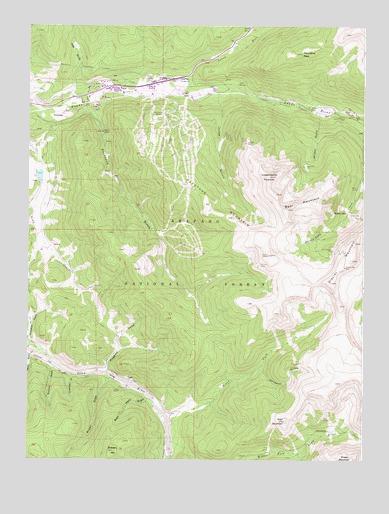
Keystone, CO USGS Topographic Map
Click on map above to begin viewing in our Map Viewer.

This topographic map contains these locations and features:
Feature Name Type Latitude Longitude GNIS ID View Map
Adrian Shaft MineMineN39.5994°W105.8808°1694407View Map
Aladdin MineMineN39.6075°W105.9045°1735413View Map
Alva MineMineN39.5486°W105.9056°1694377View Map
Bear MountainSummitN39.5722°W105.9036°182362View Map
Brewery HillSummitN39.5025°W105.9681°202877View Map
Brown GulchValleyN39.5231°W105.9705°183160View Map
California Bell MineMineN39.5586°W105.9072°1694378View Map
Camp CreekStreamN39.6055°W105.9447°182376View Map
Cold SpringSpringN39.6083°W105.9223°182382View Map
Erickson MineMineN39.5558°W105.9136°182366View Map
Florado MineMineN39.5719°W105.8828°1694382View Map
Fremont-Vineta Group MineMineN39.5133°W105.9895°1694383View Map
Frey GulchValleyN39.6051°W105.9838°181809View Map
Frey Placer ClaimsMineN39.6033°W105.9906°1694384View Map
Galena GulchValleyN39.5301°W105.9990°176200View Map
Garibaldi GulchValleyN39.5262°W105.9140°182359View Map
General Teller MineMineN39.5555°W105.8820°182368View Map
Glacier MountainSummitN39.5630°W105.8783°202878View Map
Glendale MineMineN39.5792°W105.8831°1694419View Map
Greenhorn GulchValleyN39.5242°W105.9836°182354View Map
Grizzly GulchValleyN39.5992°W105.8914°182381View Map
Hunkidori MineMineN39.5844°W105.8972°182380View Map
Ida Belle MineMineN39.5914°W105.9195°182377View Map
Independence MountainSummitN39.5819°W105.9103°182361View Map
Jones GulchValleyN39.6046°W105.9299°182374View Map
Jones Gulch ClaimsMineN39.6039°W105.9208°1694386View Map
KeystonePopulated PlaceN39.5994°W105.9872°182373View Map
Keystone Census Designated PlaceCensusN39.5901°W105.9383°2408479View Map
Keystone GulchValleyN39.6001°W105.9762°182372View Map
Keystone MineMineN39.5486°W105.9056°1694387View Map
Keystone Ski AreaLocaleN39.5905°W105.9533°182375View Map
Lake Dillon Fire - Rescue Station 11BuildingN39.6079°W105.9612°2667014View Map
Marlin MineMineN39.5780°W105.8781°182363View Map
Martin MineMineN39.5617°W105.8783°1694388View Map
Minnehaha DamDamN39.5800°W105.8756°199764View Map
Minnehaha ReservoirReservoirN39.5800°W105.8756°199765View Map
Muggins GulchValleyN39.5257°W105.9705°182357View Map
North Fork Snake RiverStreamN39.6050°W105.9420°181808View Map
North Fork Swan RiverStreamN39.5130°W105.9470°182369View Map
Peru CreekStreamN39.5969°W105.8750°181824View Map
Porcupine PeakSummitN39.6169°W105.8986°182378View Map
Preston Tunnel MineMineN39.5647°W105.8875°1694389View Map
Rainbow MineMineN39.5486°W105.9056°1694390View Map
Rexford (historical)Populated PlaceN39.5339°W105.8958°203910View Map
Reynolds DamDamN39.5825°W105.9972°199382View Map
Reynolds ReservoirReservoirN39.5815°W105.9958°197259View Map
Rock Island GulchValleyN39.5174°W105.9561°182356View Map
Royal Tiger Group MineMineN39.5230°W105.9617°1694391View Map
Saint John Tunnel MineMineN39.5880°W105.8900°1735583View Map
Saint Johns MinesMineN39.5703°W105.8783°1694392View Map
Saints John (historical)Populated PlaceN39.5717°W105.8817°182364View Map
Saints John MineMineN39.5703°W105.8786°182365View Map
Snake River Health Services Incorporated HeliportAirportN39.6039°W105.9595°204468View Map
Soda SpringSpringN39.5984°W105.8767°182379View Map
Summit County LandfillLocaleN39.6089°W105.9969°2677918View Map
Summit GulchValleyN39.5270°W105.9916°182355View Map
Swandyke (historical)LocaleN39.5083°W105.8922°203892View Map
Swandyke Post Office (historical)Post OfficeN39.5083°W105.8922°2026914View Map
Thurman GulchValleyN39.5986°W105.8761°182430View Map
Tiger (historical)Populated PlaceN39.5228°W105.9621°203919View Map
Toledo Tunnel MineMineN39.5880°W105.9592°1735584View Map
Tony MineMineN39.5030°W105.9122°182360View Map
Wild Irishman MineMineN39.5605°W105.8870°182367View Map
Wise MountainSummitN39.5111°W105.9045°182358View Map

Note: Coordinates in the location and feature list above are referenced to NAD83 datum.


Copyright (C) 2008-2024 Ryan Niemi / Sunset Dynamics ... All Rights Reserved