TopoQuest Logo
Do you find TopoQuest useful?
Help keep TopoQuest running and adding new maps/features by donating!
Bitcoin:  19c7KJd3qBynnjoSw5npx9KScwjBe4ifkT
Litecoin:  LXs6TkuXGGXo1vDsWCkWVdjQX94eUKd6ui
Home View Maps Find Maps Find Places Resources & Links


Keltys, Texas Topographic Map

USGS Map Title: Keltys, TX
USGS Map MRC: 31094C7
DRG (GeoTIFF) Download: o31094c7.tif


Neighboring USGS Topographic Map Quads:


  Wells, TX  
31094D8
 

  Clawson, TX  
31094D7
 

  Redland, TX  
31094D6
 

  Wells SW, TX  
31094C8
 

  Keltys, TX  
31094C7
 

  Lufkin, TX  
31094C6
 

  Apple Springs, TX  
31094B8
 

  Diboll, TX  
31094B7
 

  Bald Hill, TX  
31094B6


Map MRC Location:

N32°
W95°
N32°
W94°
H8 H7 H6 H5 H4 H3 H2 H1
G8 G7 G6 G5 G4 G3 G2 G1
F8 F7 F6 F5 F4 F3 F2 F1
E8 E7 E6 E5 E4 E3 E2 E1
D8 D7 D6 D5 D4 D3 D2 D1
C8 C7 C6 C5 C4 C3 C2 C1
B8 B7 B6 B5 B4 B3 B2 B1
A8 A7 A6 A5 A4 A3 A2 A1
N31°
W95°
N31°
W94°

Keltys, TX USGS 1:24K Topographic Map Preview:
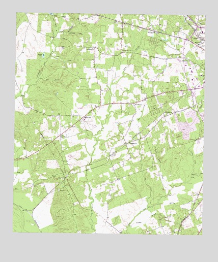
Keltys, TX USGS Topographic Map
Click on map above to begin viewing in our Map Viewer.

This topographic map contains these locations and features:
Feature Name Type Latitude Longitude GNIS ID View Map
Angelina County Constable's Office Precinct 2BuildingN31.3579°W94.7650°2751276View Map
Bethlehem ChurchChurchN31.3555°W94.8238°1381406View Map
Big Spring BranchStreamN31.3646°W94.8466°1381435View Map
Blackburn LakeReservoirN31.3735°W94.8519°1856151View Map
Blackburn Lake DamDamN31.3735°W94.8519°1856150View Map
BlixPopulated PlaceN31.2630°W94.8672°1381460View Map
Boiler Spring BranchStreamN31.2769°W94.7699°1381481View Map
Bradley BranchStreamN31.2549°W94.7983°1381503View Map
Brookhollow Elementary SchoolSchoolN31.3199°W94.7691°2003064View Map
City of HudsonCivilN31.3131°W94.8049°2410800View Map
Clark-Whitton HouseBuildingN31.3582°W94.7552°2031366View Map
Conner Spring BranchStreamN31.3616°W94.8499°1381691View Map
Crossroad ChurchChurchN31.3027°W94.7988°1381724View Map
Dubose - Fairchild CemeteryCemeteryN31.2593°W94.8476°1381801View Map
GranvillePopulated PlaceN31.2813°W94.8413°1381936View Map
Happy Hour ChurchChurchN31.3499°W94.7610°1381964View Map
HudsonPopulated PlaceN31.3227°W94.7783°1388561View Map
Hudson City HallBuildingN31.3282°W94.7811°2753151View Map
Hudson SchoolSchoolN31.3157°W94.8291°1382043View Map
Hudson Volunteer Fire DepartmentBuildingN31.3271°W94.7880°2655324View Map
Hudson Volunteer Fire Department Station 2BuildingN31.3655°W94.7813°2655208View Map
KBLZ-AM (Lufkin)TowerN31.3671°W94.7658°1385625View Map
KeltysPopulated PlaceN31.3616°W94.7510°1382101View Map
Keltys Worker HousingBuildingN31.3419°W94.7947°2030831View Map
KTRE Radio Tower (Huntsville)TowerN31.3669°W94.7663°1388243View Map
Kurkindoll CreekStreamN31.3641°W94.8405°1382109View Map
Kurth-Glover HouseBuildingN31.3552°W94.7541°2030845View Map
Largent CemeteryCemeteryN31.3552°W94.8435°1382123View Map
Largent CreekStreamN31.3507°W94.8522°1382124View Map
Levi Dunn BranchStreamN31.3377°W94.8594°1382141View Map
Little Dunn ChurchChurchN31.3546°W94.8038°1382174View Map
Mabel Melear SchoolSchoolN31.3585°W94.7547°1382215View Map
McCarty CemeteryCemeteryN31.2744°W94.8452°1382250View Map
Moccasin CreekStreamN31.2674°W94.7802°1382313View Map
Morris Franks ParkParkN31.3527°W94.7563°2029714View Map
New Hope ChurchChurchN31.3055°W94.8441°1382386View Map
Old Union ChurchChurchN31.3188°W94.7744°1382432View Map
PeavyPopulated PlaceN31.2952°W94.8108°1382469View Map
ProvidencePopulated PlaceN31.3244°W94.7963°1382579View Map
Stubblefield Learning CenterSchoolN31.3344°W94.7605°2002980View Map
Walker LakeLakeN31.3507°W94.8569°1382914View Map
Wallace CemeteryCemeteryN31.3166°W94.8488°1382916View Map
Woodland Heights Medical CenterHospitalN31.3288°W94.7543°2015608View Map
WoodlawnPopulated PlaceN31.3660°W94.7833°1382990View Map
Zed CreekStreamN31.2655°W94.7860°1383010View Map

Note: Coordinates in the location and feature list above are referenced to NAD83 datum.


Copyright (C) 2008-2024 Ryan Niemi / Sunset Dynamics ... All Rights Reserved