TopoQuest Logo
Do you find TopoQuest useful?
Help keep TopoQuest running and adding new maps/features by donating!
Bitcoin:  19c7KJd3qBynnjoSw5npx9KScwjBe4ifkT
Litecoin:  LXs6TkuXGGXo1vDsWCkWVdjQX94eUKd6ui
Home View Maps Find Maps Find Places Resources & Links


Keeneyville, Pennsylvania Topographic Map

USGS Map Title: Keeneyville, PA
USGS Map MRC: 41077G3
DRG (GeoTIFF) Download: o41077g3.tif


Neighboring USGS Topographic Map Quads:


  Knoxville, PA  
41077H4
 

  Elkland, PA  
41077H3
 

  Tioga, PA  
41077H2
 

  Asaph, PA  
41077G4
 

  Keeneyville, PA  
41077G3
 

  Crooked Creek, PA  
41077G2
 

  Tiadaghton, PA  
41077F4
 

  Antrim, PA  
41077F3
 

  Cherry Flats, PA  
41077F2


Map MRC Location:

N42°
W78°
N42°
W77°
H8 H7 H6 H5 H4 H3 H2 H1
G8 G7 G6 G5 G4 G3 G2 G1
F8 F7 F6 F5 F4 F3 F2 F1
E8 E7 E6 E5 E4 E3 E2 E1
D8 D7 D6 D5 D4 D3 D2 D1
C8 C7 C6 C5 C4 C3 C2 C1
B8 B7 B6 B5 B4 B3 B2 B1
A8 A7 A6 A5 A4 A3 A2 A1
N41°
W78°
N41°
W77°

Keeneyville, PA USGS 1:24K Topographic Map Preview:
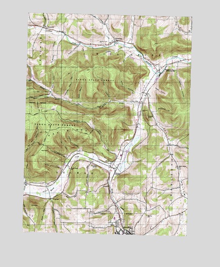
Keeneyville, PA USGS Topographic Map
Click on map above to begin viewing in our Map Viewer.

This topographic map contains these locations and features:
Feature Name Type Latitude Longitude GNIS ID View Map
Baldwin RunStreamN41.7934°W77.3250°1168659View Map
Bark Slide TrailTrailN41.8006°W77.3633°1168712View Map
Barlow HillSummitN41.7601°W77.2791°1168724View Map
Button HollowValleyN41.8569°W77.3357°1170820View Map
Canada RunStreamN41.7745°W77.3744°1192234View Map
Carpenter TrailTrailN41.8170°W77.3641°1171249View Map
Cass TrailTrailN41.8079°W77.3236°1171309View Map
Catlin HollowValleyN41.8304°W77.2815°1171347View Map
Catlin Hollow CemeteryCemeteryN41.7887°W77.2573°2774807View Map
Catlin Hollow ChurchChurchN41.7887°W77.2575°1171348View Map
Charleston CreekStreamN41.7529°W77.2964°1171581View Map
Christian HillPopulated PlaceN41.8503°W77.3516°1197641View Map
Cobble KnollSummitN41.8167°W77.2814°1172096View Map
Daly HollowValleyN41.8535°W77.2946°1172904View Map
Fuller HollowValleyN41.7869°W77.3461°1175325View Map
Heise RunPopulated PlaceN41.7695°W77.3536°1203775View Map
Heise RunStreamN41.7726°W77.3547°1176784View Map
Hemlock Flats RunStreamN41.8256°W77.3436°1176802View Map
Hemlock Flats TrailTrailN41.8381°W77.3497°1205895View Map
Hibard HollowValleyN41.7974°W77.3331°1176936View Map
Horse Thief RunStreamN41.7915°W77.3239°1177449View Map
Keck HollowValleyN41.7952°W77.3407°1178274View Map
Keeney HollowValleyN41.8574°W77.3016°1178291View Map
KeeneyvillePopulated PlaceN41.8606°W77.3047°1178293View Map
Kelsey CreekStreamN41.7523°W77.2966°1178343View Map
Log Cabin SpringSpringN41.7885°W77.3197°1179802View Map
Losey CreekStreamN41.8590°W77.3072°1179959View Map
Lost TrailTrailN41.8073°W77.3605°1179978View Map
Marsh Creek SchoolSchoolN41.7867°W77.3394°1180450View Map
Matson TrailTrailN41.7917°W77.3719°1180550View Map
Middlebury AirportAirportN41.8484°W77.2819°2442905View Map
Middlebury CenterPopulated PlaceN41.8437°W77.2744°1181062View Map
Middlebury Center Post OfficePost OfficeN41.8438°W77.2741°2773204View Map
Middlebury Township Volunteer Fire DepartmentBuildingN41.8458°W77.2722°2653037View Map
Middlebury Union CemeteryCemeteryN41.8585°W77.3179°1181063View Map
Monks HollowValleyN41.8615°W77.3516°1181421View Map
Morris BranchStreamN41.7529°W77.2964°1181568View Map
Morris MarshSwampN41.7921°W77.2992°2558326View Map
Niles HollowValleyN41.8313°W77.2912°1182457View Map
Niles TrailTrailN41.8312°W77.2955°1205892View Map
Niles ValleyPopulated PlaceN41.8251°W77.2875°1182458View Map
Niles Valley CemeteryCemeteryN41.8203°W77.2862°1182459View Map
Norris BrookStreamN41.8420°W77.2753°1182505View Map
Oak PointSummitN41.7967°W77.3611°1182791View Map
Oak RidgeRidgeN41.8070°W77.3544°1193059View Map
Oak Ridge TrailTrailN41.8079°W77.3325°1182796View Map
Oil Well HollowValleyN41.7959°W77.3747°1182891View Map
Roe HollowValleyN41.8566°W77.3322°1185381View Map
Roe TrailTrailN41.8426°W77.3294°1185382View Map
Root HollowValleyN41.8262°W77.3108°1185437View Map
Root TrailTrailN41.8334°W77.3122°1205893View Map
RoundtopSummitN41.7628°W77.3666°1185564View Map
Sanders CreekStreamN41.7679°W77.3039°1197986View Map
School House TrailTrailN41.7959°W77.3497°1205896View Map
Schoolhouse HollowValleyN41.7936°W77.3426°1187113View Map
Short CemeteryCemeteryN41.8660°W77.3691°2774850View Map
ShortsvillePopulated PlaceN41.8662°W77.3605°1204646View Map
Smith RunStreamN41.7723°W77.3561°1187887View Map
Smith RunStreamN41.8234°W77.3333°1187888View Map
Smith Run TrailTrailN41.8334°W77.3330°1205894View Map
Spoor HollowValleyN41.8285°W77.3560°1188191View Map
StokesdalePopulated PlaceN41.7776°W77.3094°1204741View Map
Sweet HollowValleyN41.8306°W77.3557°1189170View Map
Sweet HollowValleyN41.8479°W77.2601°1189171View Map
Tioga CountyCivilN41.7722°W77.2543°1209189View Map
Township of MiddleburyCivilN41.8639°W77.2656°1217116View Map
Wedge HollowValleyN41.8339°W77.2782°1190768View Map
Wellsboro CemeteryCemeteryN41.7552°W77.3016°2774862View Map
Wellsboro JunctionPopulated PlaceN41.7873°W77.3041°1204918View Map
Wellsboro Post OfficePost OfficeN41.7500°W77.2994°2768372View Map
Whitehouse HollowValleyN41.8203°W77.2771°1191327View Map
Wolf RunStreamN41.7731°W77.3530°1191678View Map

Note: Coordinates in the location and feature list above are referenced to NAD83 datum.


Copyright (C) 2008-2024 Ryan Niemi / Sunset Dynamics ... All Rights Reserved