TopoQuest Logo
Do you find TopoQuest useful?
Help keep TopoQuest running and adding new maps/features by donating!
Bitcoin:  19c7KJd3qBynnjoSw5npx9KScwjBe4ifkT
Litecoin:  LXs6TkuXGGXo1vDsWCkWVdjQX94eUKd6ui
Home View Maps Find Maps Find Places Resources & Links


Jefferson, South Carolina Topographic Map

USGS Map Title: Jefferson, SC
USGS Map MRC: 34080F4
DRG (GeoTIFF) Download: o34080f4.tif


Neighboring USGS Topographic Map Quads:


  Tradesville, SC  
34080G5
 

  Pageland, SC  
34080G4
 

  Hornsboro, SC  
34080G3
 

  Taxahaw, SC  
34080F5
 

  Jefferson, SC  
34080F4
 

  Jefferson NE, SC  
34080F3
 

  Kershaw, SC  
34080E5
 

  Mount Pisgah, SC  
34080E4
 

  Angelus, SC  
34080E3


Map MRC Location:

N35°
W81°
N35°
W80°
H8 H7 H6 H5 H4 H3 H2 H1
G8 G7 G6 G5 G4 G3 G2 G1
F8 F7 F6 F5 F4 F3 F2 F1
E8 E7 E6 E5 E4 E3 E2 E1
D8 D7 D6 D5 D4 D3 D2 D1
C8 C7 C6 C5 C4 C3 C2 C1
B8 B7 B6 B5 B4 B3 B2 B1
A8 A7 A6 A5 A4 A3 A2 A1
N34°
W81°
N34°
W80°

Jefferson, SC USGS 1:24K Topographic Map Preview:
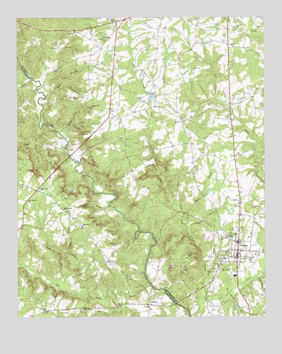
Jefferson, SC USGS Topographic Map
Click on map above to begin viewing in our Map Viewer.

This topographic map contains these locations and features:
Feature Name Type Latitude Longitude GNIS ID View Map
Almetta ChurchChurchN34.6493°W80.3837°1220188View Map
Arant BranchStreamN34.7238°W80.4892°1220226View Map
Belk BranchStreamN34.7038°W80.4876°1245040View Map
BirdtownPopulated PlaceN34.6302°W80.4334°1246894View Map
Blackman CemeteryCemeteryN34.6785°W80.4884°1220782View Map
Canal BranchStreamN34.6629°W80.4134°1221298View Map
Cedar Falls BranchStreamN34.7002°W80.4756°1221446View Map
Charlesboro ChurchChurchN34.6635°W80.4673°1247257View Map
Charlesboro School (historical)SchoolN34.6635°W80.4681°1241619View Map
Charlesboro School (historical)SchoolN34.6702°W80.4767°1241620View Map
Cooks Mill (historical)LocaleN34.6960°W80.4745°1235634View Map
Dry CreekStreamN34.6343°W80.4456°1222113View Map
Ethel Plyler Pond Dam D-3171DamN34.7168°W80.4315°1240016View Map
Five Fork CemeteryCemeteryN34.7415°W80.4545°1222416View Map
Five ForksPopulated PlaceN34.7418°W80.4531°1235658View Map
Five Forks ChurchChurchN34.7390°W80.4540°1235659View Map
Five Forks School (historical)SchoolN34.7413°W80.4537°1235660View Map
Flat CreekStreamN34.6388°W80.4328°1222431View Map
Flat Creek ChurchChurchN34.6282°W80.4662°1247763View Map
Flat Creek Fire Department SubstationBuildingN34.6720°W80.4786°2578809View Map
Griffins FordCrossingN34.6546°W80.4323°1235671View Map
Hopewell CemeteryCemeteryN34.6710°W80.3809°1223282View Map
Hopewell ChurchChurchN34.6524°W80.3937°1246051View Map
Horton Spring BranchStreamN34.6968°W80.4909°1223351View Map
JeffersonPopulated PlaceN34.6502°W80.3890°1223522View Map
Jefferson CemeteryCemeteryN34.6585°W80.3976°1223524View Map
Jefferson Elementary SchoolSchoolN34.6563°W80.3887°1235682View Map
Jefferson Fire DepartmentBuildingN34.6517°W80.3874°2578552View Map
Jefferson Rescue SquadBuildingN34.6519°W80.3873°2739561View Map
Joes BranchStreamN34.6340°W80.3945°1223585View Map
Lick RunStreamN34.6360°W80.4753°1223904View Map
Little Fork CreekStreamN34.6310°W80.4053°1223991View Map
Macedonia ChurchChurchN34.6279°W80.4856°1246507View Map
McManns FordCrossingN34.7243°W80.4917°1251778View Map
Meeting House BranchStreamN34.6415°W80.3809°1224443View Map
Mill BranchStreamN34.6513°W80.4773°1224512View Map
Mill BranchStreamN34.6452°W80.3751°1224523View Map
Miller - Lowery CemeteryCemeteryN34.6596°W80.3884°1224571View Map
Mose BranchStreamN34.6646°W80.4142°1224663View Map
Mount Ariel ChurchChurchN34.6468°W80.3970°1235718View Map
Mount Canaan Baptist ChurchChurchN34.6452°W80.3967°1249556View Map
Mount Harmon ChurchChurchN34.7379°W80.3901°1224710View Map
Mount Harmon School (historical)SchoolN34.7379°W80.3906°1235722View Map
New Haven ChurchChurchN34.6479°W80.4542°1224973View Map
New Testament ChurchChurchN34.6732°W80.4951°1225026View Map
Oak Hill ChurchChurchN34.7438°W80.4712°1225122View Map
Oak Hill School (historical)SchoolN34.7432°W80.4723°1235730View Map
Plains School (historical)SchoolN34.7068°W80.4151°1235750View Map
Plyers Mill (historical)LocaleN34.7149°W80.4317°1235754View Map
Plyler PondLakeN34.7170°W80.4322°1225568View Map
Reedy ForkStreamN34.7168°W80.4295°1225821View Map
Rock Hill ChurchChurchN34.6882°W80.4340°1225937View Map
Rocky BranchStreamN34.6718°W80.4534°1250435View Map
Rocky Branch Baptist ChurchChurchN34.6699°W80.4765°1225971View Map
Sandhill Volunteer Fire Department Station 3BuildingN34.6881°W80.3902°2578728View Map
Shannon SchoolSchoolN34.6460°W80.3984°1250845View Map
Shop BranchStreamN34.7179°W80.4853°1226595View Map
Terry Lake Dam D-3172DamN34.6968°W80.4315°1240015View Map
Town of JeffersonCivilN34.6512°W80.3867°2405909View Map
Turkey CreekStreamN34.7240°W80.4915°1227242View Map
Union Hill ChurchChurchN34.7165°W80.4695°1227302View Map
White PlainsPopulated PlaceN34.7071°W80.4165°1235803View Map
White Plains Baptist ChurchChurchN34.7068°W80.4153°1251417View Map
White Plains CemeteryCemeteryN34.7075°W80.4150°1248748View Map
White Plains School (historical)SchoolN34.6907°W80.4315°1235804View Map

Note: Coordinates in the location and feature list above are referenced to NAD83 datum.


Copyright (C) 2008-2024 Ryan Niemi / Sunset Dynamics ... All Rights Reserved