TopoQuest Logo
Do you find TopoQuest useful?
Help keep TopoQuest running and adding new maps/features by donating!
Bitcoin:  19c7KJd3qBynnjoSw5npx9KScwjBe4ifkT
Litecoin:  LXs6TkuXGGXo1vDsWCkWVdjQX94eUKd6ui
Home View Maps Find Maps Find Places Resources & Links


Hutton, Indiana Topographic Map

USGS Map Title: Hutton, IN
USGS Map MRC: 39087C5
DRG (GeoTIFF) Download: o39087c5.tif


Neighboring USGS Topographic Map Quads:


  Marshall, IL  
39087D6
 

  Dennison, IL  
39087D5
 

  Terre Haute, IN  
39087D4
 

  Snyder, IL  
39087C6
 

  Hutton, IN  
39087C5
 

  Pimento, IN  
39087C4
 

  West Union, IL  
39087B6
 

  Fairbanks, IN  
39087B5
 

  Shelburn, IN  
39087B4


Map MRC Location:

N40°
W88°
N40°
W87°
H8 H7 H6 H5 H4 H3 H2 H1
G8 G7 G6 G5 G4 G3 G2 G1
F8 F7 F6 F5 F4 F3 F2 F1
E8 E7 E6 E5 E4 E3 E2 E1
D8 D7 D6 D5 D4 D3 D2 D1
C8 C7 C6 C5 C4 C3 C2 C1
B8 B7 B6 B5 B4 B3 B2 B1
A8 A7 A6 A5 A4 A3 A2 A1
N39°
W88°
N39°
W87°

Hutton, IN USGS 1:24K Topographic Map Preview:
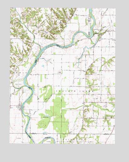
Hutton, IN USGS Topographic Map
Click on map above to begin viewing in our Map Viewer.

This topographic map contains these locations and features:
Feature Name Type Latitude Longitude GNIS ID View Map
Ashmore CreekStreamN39.3542°W87.5439°403680View Map
Aurora BendBendN39.3045°W87.6150°430348View Map
Big CreekStreamN39.3359°W87.5886°404392View Map
Big KnollSummitN39.3148°W87.5664°431042View Map
Blue HoleLakeN39.3496°W87.5198°431226View Map
Bohn Ferry (historical)LocaleN39.2598°W87.6042°1736435View Map
Center Hill ChurchChurchN39.3186°W87.5336°432333View Map
Cooper ChapelChurchN39.3611°W87.5672°406551View Map
DarwinPopulated PlaceN39.2834°W87.6120°406956View Map
Darwin CemeteryCemeteryN39.2814°W87.6111°406957View Map
Darwin FerryLocaleN39.2834°W87.6100°433323View Map
Darwin FerryLocaleN39.2831°W87.6100°406958View Map
Dean CemeteryCemeteryN39.3511°W87.6061°407035View Map
Dog RunStreamN39.3611°W87.5536°407281View Map
Grassy PondLakeN39.2984°W87.5759°447915View Map
Greenfield BayouLakeN39.3302°W87.5397°435436View Map
Hall CemeteryCemeteryN39.3253°W87.6086°409656View Map
Hall School (historical)SchoolN39.3256°W87.6095°1736446View Map
Hayworth SloughStreamN39.3503°W87.5272°435933View Map
Higginbotham Field (historical)AirportN39.3414°W87.5314°449315View Map
HuttonPopulated PlaceN39.3175°W87.5339°436664View Map
Liberty Square School (historical)SchoolN39.3611°W87.5670°1736450View Map
Lick BranchStreamN39.3561°W87.6042°1785492View Map
Liffick CemeteryCemeteryN39.3684°W87.5525°419115View Map
Little CreekStreamN39.3631°W87.6136°412319View Map
Little Grassy PondLakeN39.3027°W87.5807°438065View Map
Lykens CemeteryCemeteryN39.2798°W87.5364°438426View Map
Mackey CemeteryCemeteryN39.3611°W87.6181°412801View Map
Martin BranchStreamN39.3211°W87.6170°413064View Map
Muskrat PondLakeN39.2755°W87.5809°439903View Map
Neely CreekStreamN39.3014°W87.6189°414335View Map
Negro DitchCanalN39.3039°W87.5642°439985View Map
New Harmony CemeteryCemeteryN39.3464°W87.5001°440053View Map
Oxendine BayouStreamN39.2761°W87.6036°440816View Map
Partridge CreekStreamN39.3059°W87.6214°415423View Map
Prairie Creek Township Fire DepartmentBuildingN39.2743°W87.5009°2626224View Map
Round PondLakeN39.2600°W87.5826°442358View Map
Shattuck CemeteryCemeteryN39.3034°W87.5328°443316View Map
South Prairie CreekStreamN39.2573°W87.5200°447918View Map
Stone Pond (historical)LakeN39.3067°W87.5647°447925View Map
Sugar CreekStreamN39.3061°W87.6214°419283View Map
Taylor FordCrossingN39.3748°W87.6192°1736467View Map
Thompson CemeteryCemeteryN39.3506°W87.5939°419667View Map
Township of Prairie CreekCivilN39.2954°W87.5324°453774View Map
VigoPopulated PlaceN39.2873°W87.5372°445288View Map
Waters FordCrossingN39.3459°W87.5961°1736470View Map
Watson CemeteryCemeteryN39.2917°W87.5234°445552View Map
West Prairie Creek CemeteryCemeteryN39.2748°W87.5028°445803View Map

Note: Coordinates in the location and feature list above are referenced to NAD83 datum.


Copyright (C) 2008-2024 Ryan Niemi / Sunset Dynamics ... All Rights Reserved