TopoQuest Logo
Do you find TopoQuest useful?
Help keep TopoQuest running and adding new maps/features by donating!
Bitcoin:  19c7KJd3qBynnjoSw5npx9KScwjBe4ifkT
Litecoin:  LXs6TkuXGGXo1vDsWCkWVdjQX94eUKd6ui
Home View Maps Find Maps Find Places Resources & Links


Huffman, Texas Topographic Map

USGS Map Title: Huffman, TX
USGS Map MRC: 30095A1
DRG (GeoTIFF) Download: o30095a1.tif


Neighboring USGS Topographic Map Quads:


  Splendora, TX  
30095B2
 

  Plum Grove, TX  
30095B1
 

  Simmons Bottom, TX  
30094B8
 

  Moonshine Hill, TX  
30095A2
 

  Huffman, TX  
30095A1
 

  Dayton, TX  
30094A8
 

  Harmaston, TX  
29095H2
 

  Crosby, TX  
29095H1
 

  Sheeks, TX  
29094H8


Map MRC Location:

N31°
W96°
N31°
W95°
H8 H7 H6 H5 H4 H3 H2 H1
G8 G7 G6 G5 G4 G3 G2 G1
F8 F7 F6 F5 F4 F3 F2 F1
E8 E7 E6 E5 E4 E3 E2 E1
D8 D7 D6 D5 D4 D3 D2 D1
C8 C7 C6 C5 C4 C3 C2 C1
B8 B7 B6 B5 B4 B3 B2 B1
A8 A7 A6 A5 A4 A3 A2 A1
N30°
W96°
N30°
W95°

Huffman, TX USGS 1:24K Topographic Map Preview:
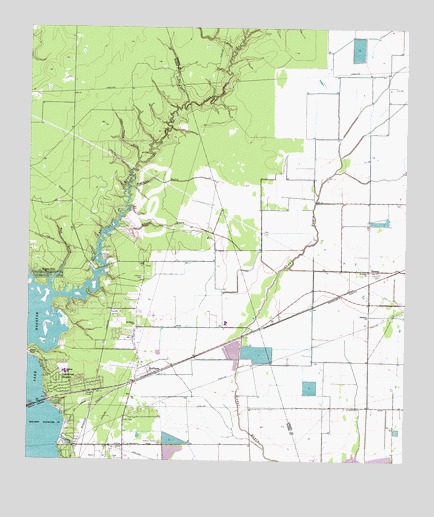
Huffman, TX USGS Topographic Map
Click on map above to begin viewing in our Map Viewer.

This topographic map contains these locations and features:
Feature Name Type Latitude Longitude GNIS ID View Map
Ben Bowen Elementary SchoolSchoolN30.0195°W95.1106°2472526View Map
Bowen Elementary SchoolSchoolN30.0258°W95.1113°2005326View Map
Calvary Baptist Chapel ChurchChurchN30.0386°W95.0799°2019258View Map
Camp BranchStreamN30.1166°W95.0588°1331948View Map
Church on the LakeChurchN30.0145°W95.1124°2470746View Map
Copeland Intermediate SchoolSchoolN30.0258°W95.1113°2005284View Map
Copeland SchoolSchoolN30.0230°W95.1116°2472539View Map
EastgatePopulated PlaceN30.0555°W95.0119°1335043View Map
Eastgate ChurchChurchN30.0419°W95.0127°1335044View Map
Glad Tidings Pentecostal Church of GodChurchN30.1063°W95.1122°2020264View Map
Hargrave High SchoolSchoolN30.0419°W95.0597°2006118View Map
Hidden EchoPopulated PlaceN30.0538°W95.1194°1378447View Map
Houston Fire Department / Emergency Medical Services Station 65BuildingN30.0206°W95.1031°2334743View Map
Houston Fire Station Number 65BuildingN30.0202°W95.1060°2470964View Map
Houston Police Department - Lake HoustonBuildingN30.0037°W95.1138°2375842View Map
HuffmanPopulated PlaceN30.0272°W95.0858°1338230View Map
Huffman CemeteryCemeteryN30.0530°W95.0877°1338231View Map
Huffman ChurchChurchN30.0394°W95.0899°1338232View Map
Huffman Community CemeteryCemeteryN30.0049°W95.0805°1338233View Map
Huffman Middle SchoolSchoolN30.0401°W95.0596°2006070View Map
Huffman OaksPopulated PlaceN30.0249°W95.0902°2472034View Map
Huffman Post OfficePost OfficeN30.0348°W95.0889°2732337View Map
Huffman SchoolSchoolN30.0255°W95.1133°1338234View Map
Huffman Volunteer Fire Department Station 1BuildingN30.0250°W95.0899°2334398View Map
John Young GullyValleyN30.0863°W95.0891°1338769View Map
Key GullyValleyN30.1030°W95.0741°1339067View Map
L T May ParkParkN30.0558°W95.0622°2029066View Map
Lake Houston United Methodist ChurchChurchN30.0215°W95.1123°2471055View Map
Lakeside ManorPopulated PlaceN30.0062°W95.1094°2472076View Map
Lakewood HeightsPopulated PlaceN30.0222°W95.1144°1339557View Map
LuceLocaleN30.0733°W95.0913°1340714View Map
Luce BayouStreamN30.0474°W95.1147°1340715View Map
May Community CenterBuildingN30.0565°W95.0619°2471005View Map
Mexican GullyValleyN30.0792°W95.0914°1341447View Map
Red GullyValleyN30.0516°W95.1180°1344918View Map
Saint Annes CemeteryCemeteryN30.0538°W95.0088°1345858View Map
Saint Annes ChurchChurchN30.0547°W95.0130°1345859View Map
Saint Philip the Apostle Catholic ChurchChurchN30.0271°W95.0852°2471147View Map
Scotts PointCapeN30.0319°W95.1244°1346826View Map
Seaberg Reservoir Number 1ReservoirN30.0278°W95.0562°1860934View Map
Seaberg Reservoir Number 1 LeveeDamN30.0269°W95.0569°1860933View Map
Seaberg Reservoir Number 2ReservoirN30.0324°W95.0570°1860932View Map
Seaberg Reservoir Number 2 LeveeDamN30.0302°W95.0552°1860931View Map
Seaberg Reservoir Number 3ReservoirN30.0060°W95.0774°1860928View Map
Seaberg Reservoir Number 3 DamDamN30.0052°W95.0719°1860927View Map
Seaberg Reservoir Number 4ReservoirN30.0309°W95.0489°1860930View Map
Seaberg Reservoir Number 4 DamDamN30.0302°W95.0535°1860929View Map
Shook GullyValleyN30.0680°W95.0944°1347088View Map
ShorewoodPopulated PlaceN30.0024°W95.1119°2472636View Map
Vine Life Fellowship ChurchChurchN30.0041°W95.1024°2020076View Map

Note: Coordinates in the location and feature list above are referenced to NAD83 datum.


Copyright (C) 2008-2024 Ryan Niemi / Sunset Dynamics ... All Rights Reserved