TopoQuest Logo
Do you find TopoQuest useful?
Help keep TopoQuest running and adding new maps/features by donating!
Bitcoin:  19c7KJd3qBynnjoSw5npx9KScwjBe4ifkT
Litecoin:  LXs6TkuXGGXo1vDsWCkWVdjQX94eUKd6ui
Home View Maps Find Maps Find Places Resources & Links


Horsetooth Reservoir, Colorado Topographic Map

USGS Map Title: Horsetooth Reservoir, CO
USGS Map MRC: 40105E2
DRG (GeoTIFF) Download: o40105e2.tif


Neighboring USGS Topographic Map Quads:


  Poudre Park, CO  
40105F3
 

  Laporte, CO  
40105F2
 

  Wellington, CO  
40105F1
 

  Buckhorn Mountain, CO  
40105E3
 

  Horsetooth Reservoir, CO  
40105E2
 

  Fort Collins, CO  
40105E1
 

  Drake, CO  
40105D3
 

  Masonville, CO  
40105D2
 

  Loveland, CO  
40105D1


Map MRC Location:

N41°
W106°
N41°
W105°
H8 H7 H6 H5 H4 H3 H2 H1
G8 G7 G6 G5 G4 G3 G2 G1
F8 F7 F6 F5 F4 F3 F2 F1
E8 E7 E6 E5 E4 E3 E2 E1
D8 D7 D6 D5 D4 D3 D2 D1
C8 C7 C6 C5 C4 C3 C2 C1
B8 B7 B6 B5 B4 B3 B2 B1
A8 A7 A6 A5 A4 A3 A2 A1
N40°
W106°
N40°
W105°

Horsetooth Reservoir, CO USGS 1:24K Topographic Map Preview:
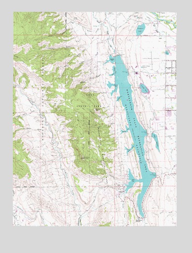
Horsetooth Reservoir, CO USGS Topographic Map
Click on map above to begin viewing in our Map Viewer.

This topographic map contains these locations and features:
Feature Name Type Latitude Longitude GNIS ID View Map
Arthurs RockPillarN40.5683°W105.1880°177404View Map
Arthurs Rock GulchValleyN40.5736°W105.1699°177412View Map
Ball Scheelite MineMineN40.5586°W105.2392°1683538View Map
Bardwell Family CemeteryCemeteryN40.5711°W105.2164°2036974View Map
Bellvue State Fish HatcheryLocaleN40.6244°W105.1769°169486View Map
Bingham HillSummitN40.6230°W105.1583°177386View Map
Brown GulchValleyN40.6174°W105.2002°177402View Map
Buckhorn Highline DitchCanalN40.5028°W105.2464°202452View Map
Cache la Poudre MonumentParkN40.6239°W105.1680°177375View Map
Christman FieldAirportN40.5982°W105.1444°204399View Map
Claymore DamDamN40.6116°W105.1558°201262View Map
Claymore LakeReservoirN40.6148°W105.1530°177389View Map
Cloudy SpringSpringN40.6214°W105.2041°177379View Map
College LakeReservoirN40.5802°W105.1500°177390View Map
College Number 3 DamDamN40.5819°W105.1494°201264View Map
Devil GulchValleyN40.6064°W105.1910°177407View Map
Dixon CanalCanalN40.5666°W105.1433°177383View Map
Dixon Canyon DamDamN40.5544°W105.1480°177399View Map
Dixon CoveBayN40.5450°W105.1603°177393View Map
Dixon ReservoirReservoirN40.5500°W105.1409°177391View Map
Dry LakeLocaleN40.5305°W105.1294°177378View Map
Eltuck BayBayN40.5819°W105.1716°177396View Map
Empire GulchValleyN40.6092°W105.1778°177408View Map
Estes Belle ClaimMineN40.5153°W105.2194°1683539View Map
Happy Hollow GulchValleyN40.5676°W105.2299°177372View Map
Hilltop ClaimMineN40.5153°W105.2194°1683540View Map
Horsetooth DamDamN40.5994°W105.1711°177401View Map
Horsetooth HeightsPopulated PlaceN40.5044°W105.1541°177388View Map
Horsetooth MountainSummitN40.5397°W105.1969°177409View Map
Horsetooth ReservoirReservoirN40.5583°W105.1595°177416View Map
Hughes StadiumParkN40.5622°W105.1414°177384View Map
Inlet BayBayN40.5264°W105.1586°177392View Map
KCSU-FM (Fort Collins)TowerN40.6000°W105.1564°204129View Map
Kinnison Family CemeteryCemeteryN40.5491°W105.1972°2036959View Map
KTCL-FM (Fort Collins)TowerN40.5491°W105.1975°204128View Map
Labeau GulchValleyN40.6065°W105.1910°177406View Map
Laporte CemeteryCemeteryN40.6196°W105.1443°203934View Map
Laurence CreekStreamN40.5816°W105.2464°177371View Map
Lory State ParkParkN40.5744°W105.1905°197722View Map
Lory State Park CemeteryCemeteryN40.5738°W105.2097°2036965View Map
Mill CanyonValleyN40.6180°W105.1829°177405View Map
Mill CreekStreamN40.5566°W105.1678°177411View Map
Mountain ViewPopulated PlaceN40.5925°W105.1291°202461View Map
Orchard CoveBayN40.5744°W105.1697°177395View Map
Overland Stage StationLocaleN40.6230°W105.1383°177385View Map
Patterson GraveCemeteryN40.5503°W105.2180°2036937View Map
Pleasant Valley and Lake CanalCanalN40.6028°W105.1450°202433View Map
Poudre Fire Authority Station 11BuildingN40.5742°W105.2390°2667197View Map
Poudre Fire Authority Station 9BuildingN40.5196°W105.1679°2667195View Map
Poudre Fire Authority Training CenterBuildingN40.5968°W105.1396°2666970View Map
Quarry CoveBayN40.5555°W105.1636°177394View Map
Rist Canyon Volunteer Fire Department Station 4 Whale RockBuildingN40.6242°W105.2203°2667237View Map
Satanka CoveBayN40.5969°W105.1747°177381View Map
Satanka Dike DamDamN40.5966°W105.1705°200678View Map
Soldier CanyonValleyN40.5883°W105.1767°177382View Map
Soldier Canyon CoveBayN40.5903°W105.1728°177397View Map
Soldier Canyon DamDamN40.5897°W105.1625°177400View Map
Soldier Canyon ReservoirReservoirN40.5929°W105.1520°177380View Map
Spring CanyonValleyN40.5236°W105.1627°177413View Map
Spring Canyon DamDamN40.5297°W105.1408°177398View Map
Spring CreekStreamN40.5189°W105.1639°177414View Map
Spring Creek DamDamN40.5297°W105.1408°199642View Map
Spruce GulchValleyN40.5555°W105.2216°177355View Map
U S Soldier GraveCemeteryN40.6211°W105.1841°2036928View Map
Well GulchValleyN40.5781°W105.1740°177410View Map

Note: Coordinates in the location and feature list above are referenced to NAD83 datum.


Copyright (C) 2008-2024 Ryan Niemi / Sunset Dynamics ... All Rights Reserved