TopoQuest Logo
Do you find TopoQuest useful?
Help keep TopoQuest running and adding new maps/features by donating!
Bitcoin:  19c7KJd3qBynnjoSw5npx9KScwjBe4ifkT
Litecoin:  LXs6TkuXGGXo1vDsWCkWVdjQX94eUKd6ui
Home View Maps Find Maps Find Places Resources & Links


Horcado Ranch, New Mexico Topographic Map

USGS Map Title: Horcado Ranch, NM
USGS Map MRC: 35106G1
DRG (GeoTIFF) Download: o35106g1.tif


Neighboring USGS Topographic Map Quads:


  Puye, NM  
35106H2
 

  Espanola, NM  
35106H1
 

  Cundiyo, NM  
35105H8
 

  White Rock, NM  
35106G2
 

  Horcado Ranch, NM  
35106G1
 

  Tesuque, NM  
35105G8
 

  Montoso Peak, NM  
35106F2
 

  Agua Fria, NM  
35106F1
 

  Santa Fe, NM  
35105F8


Map MRC Location:

N36°
W107°
N36°
W106°
H8 H7 H6 H5 H4 H3 H2 H1
G8 G7 G6 G5 G4 G3 G2 G1
F8 F7 F6 F5 F4 F3 F2 F1
E8 E7 E6 E5 E4 E3 E2 E1
D8 D7 D6 D5 D4 D3 D2 D1
C8 C7 C6 C5 C4 C3 C2 C1
B8 B7 B6 B5 B4 B3 B2 B1
A8 A7 A6 A5 A4 A3 A2 A1
N35°
W107°
N35°
W106°

Horcado Ranch, NM USGS 1:24K Topographic Map Preview:
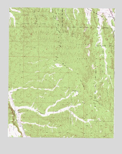
Horcado Ranch, NM USGS Topographic Map
Click on map above to begin viewing in our Map Viewer.

This topographic map contains these locations and features:
Feature Name Type Latitude Longitude GNIS ID View Map
Calabasa ArroyoArroyoN35.7778°W106.1186°918088View Map
CuyamunguePopulated PlaceN35.8697°W106.0042°928720View Map
Cuyamungue Census Designated PlaceCensusN35.8648°W106.0096°2408638View Map
Fraction MineMineN35.7834°W106.0006°939978View Map
Horcado RanchLocaleN35.7953°W106.0447°907082View Map
Jacona GrantCivilN35.8414°W106.0392°918203View Map
Kosack Mining Company MineMineN35.7834°W106.0006°939982View Map
Las DosPopulated PlaceN35.7617°W106.0306°907868View Map
New Boondk Water WellWellN35.8270°W106.1109°926832View Map
Norton SubstationLocaleN35.7636°W106.1086°916049View Map
Ortiz Water WellWellN35.8061°W106.0845°926831View Map
RG-10843 Water WellWellN35.8678°W106.0114°926835View Map
RG-11784 Water WellWellN35.8539°W106.0092°926834View Map
RG-20606 Water WellWellN35.7922°W106.0392°926829View Map
RG-26777 Water WellWellN35.7503°W106.0339°922638View Map
RG-27065 Water WellWellN35.7509°W106.0303°926827View Map
RG-2833 Water WellWellN35.8431°W106.0131°926833View Map
RG-438 Water WellWellN35.7956°W106.1150°926830View Map
RG-6386 Water WellWellN35.7731°W106.0497°926828View Map

Note: Coordinates in the location and feature list above are referenced to NAD83 datum.


Copyright (C) 2008-2024 Ryan Niemi / Sunset Dynamics ... All Rights Reserved