TopoQuest Logo
Do you find TopoQuest useful?
Help keep TopoQuest running and adding new maps/features by donating!
Bitcoin:  19c7KJd3qBynnjoSw5npx9KScwjBe4ifkT
Litecoin:  LXs6TkuXGGXo1vDsWCkWVdjQX94eUKd6ui
Home View Maps Find Maps Find Places Resources & Links


Hobart Mills, California Topographic Map

USGS Map Title: Hobart Mills, CA
USGS Map MRC: 39120D2
DRG (GeoTIFF) Download: o39120d2.tif


Neighboring USGS Topographic Map Quads:


  Sierraville, CA  
39120E3
 

  Sardine Peak, CA  
39120E2
 

  Dog Valley, CA  
39120E1
 

  Independence Lake, CA  
39120D3
 

  Hobart Mills, CA  
39120D2
 

  Boca, CA  
39120D1
 

  Norden, CA  
39120C3
 

  Truckee, CA  
39120C2
 

  Martis Peak, CA  
39120C1


Map MRC Location:

N40°
W121°
N40°
W120°
H8 H7 H6 H5 H4 H3 H2 H1
G8 G7 G6 G5 G4 G3 G2 G1
F8 F7 F6 F5 F4 F3 F2 F1
E8 E7 E6 E5 E4 E3 E2 E1
D8 D7 D6 D5 D4 D3 D2 D1
C8 C7 C6 C5 C4 C3 C2 C1
B8 B7 B6 B5 B4 B3 B2 B1
A8 A7 A6 A5 A4 A3 A2 A1
N39°
W121°
N39°
W120°

Hobart Mills, CA USGS 1:24K Topographic Map Preview:
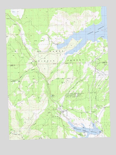
Hobart Mills, CA USGS Topographic Map
Click on map above to begin viewing in our Map Viewer.

This topographic map contains these locations and features:
Feature Name Type Latitude Longitude GNIS ID View Map
Alder CreekStreamN39.3788°W120.1521°266371View Map
Annie McCloud CampgroundLocaleN39.3807°W120.1355°276122View Map
Billy HillSummitN39.4285°W120.1819°257062View Map
Captain Roberts Boat RampLocaleN39.4707°W120.1338°276129View Map
Donner Camp Picnic AreaLocaleN39.3769°W120.1821°276123View Map
Hobart MillsPopulated PlaceN39.4005°W120.1838°1658762View Map
Hobart ReservoirReservoirN39.4160°W120.1975°261378View Map
Lakeside CampgroundLocaleN39.3846°W120.1724°1670053View Map
Logger CampgroundLocaleN39.4663°W120.1296°276128View Map
Lower Little Truckee CampgroundLocaleN39.4855°W120.2374°276131View Map
Lower Little Truckee CampgroundLocaleN39.4707°W120.1338°276130View Map
North Fork Prosser CreekStreamN39.3819°W120.2399°264199View Map
Old Smith Mill (historical)LocaleN39.4652°W120.1905°1670065View Map
Prosser CampgroundLocaleN39.3777°W120.1616°276126View Map
Prosser Creek DamDamN39.3791°W120.1399°1664652View Map
Prosser Creek ReservoirReservoirN39.3803°W120.1567°1654936View Map
Prosser HillSummitN39.3752°W120.2171°265051View Map
Prosser Ranch Group CampgroundLocaleN39.3788°W120.1552°276127View Map
Sagehen CreekStreamN39.4769°W120.1319°265726View Map
Sagehen Creek CampgroundLocaleN39.4344°W120.2483°1662479View Map
Sagehen HillsRangeN39.4099°W120.2402°267203View Map
South Fork Prosser CreekStreamN39.3819°W120.2399°267491View Map
Stampede ReservoirReservoirN39.4782°W120.1354°267662View Map
University of California Wildlife Experiment StationLocaleN39.4319°W120.2410°1670057View Map
Upper Little Truckee CampgroundLocaleN39.4907°W120.2449°276134View Map
Winnie Smith Mill (historical)LocaleN39.4505°W120.1410°1670068View Map
Woodchoppers SpringSpringN39.4052°W120.1428°269287View Map

Note: Coordinates in the location and feature list above are referenced to NAD83 datum.


Copyright (C) 2008-2024 Ryan Niemi / Sunset Dynamics ... All Rights Reserved