TopoQuest Logo
Do you find TopoQuest useful?
Help keep TopoQuest running and adding new maps/features by donating!
Bitcoin:  19c7KJd3qBynnjoSw5npx9KScwjBe4ifkT
Litecoin:  LXs6TkuXGGXo1vDsWCkWVdjQX94eUKd6ui
Home View Maps Find Maps Find Places Resources & Links


Heidelberg, Kentucky Topographic Map

USGS Map Title: Heidelberg, KY
USGS Map MRC: 37083E7
DRG (GeoTIFF) Download: o37083e7.tif


Neighboring USGS Topographic Map Quads:


  Irvine, KY  
37083F8
 

  Cobhill, KY  
37083F7
 

  Zachariah, KY  
37083F6
 

  Leighton, KY  
37083E8
 

  Heidelberg, KY  
37083E7
 

  Beattyville, KY  
37083E6
 

  McKee, KY  
37083D8
 

  Sturgeon, KY  
37083D7
 

  Booneville, KY  
37083D6


Map MRC Location:

N38°
W84°
N38°
W83°
H8 H7 H6 H5 H4 H3 H2 H1
G8 G7 G6 G5 G4 G3 G2 G1
F8 F7 F6 F5 F4 F3 F2 F1
E8 E7 E6 E5 E4 E3 E2 E1
D8 D7 D6 D5 D4 D3 D2 D1
C8 C7 C6 C5 C4 C3 C2 C1
B8 B7 B6 B5 B4 B3 B2 B1
A8 A7 A6 A5 A4 A3 A2 A1
N37°
W84°
N37°
W83°

Heidelberg, KY USGS 1:24K Topographic Map Preview:
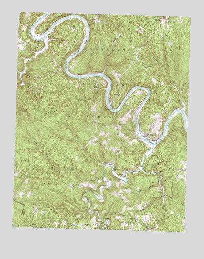
Heidelberg, KY USGS Topographic Map
Click on map above to begin viewing in our Map Viewer.

This topographic map contains these locations and features:
Feature Name Type Latitude Longitude GNIS ID View Map
Angel CemeteryCemeteryN37.6084°W83.8316°510271View Map
Barker Rockhouse BranchStreamN37.5195°W83.7658°510404View Map
Bear Track CampLocaleN37.6243°W83.7713°516780View Map
Bear Track Mission SchoolSchoolN37.6240°W83.7705°510472View Map
Bear Track ParkParkN37.6242°W83.7657°2377157View Map
Beartrack Volunteer Fire DepartmentBuildingN37.6245°W83.7778°2637234View Map
Beatty Place CemeteryCemeteryN37.5987°W83.7894°510485View Map
Big Stonecoal BranchStreamN37.5062°W83.8080°510702View Map
Brandenburg CemeteryCemeteryN37.5231°W83.8146°510894View Map
Brandenburg CemeteryCemeteryN37.5440°W83.7766°510895View Map
Buck Lick BranchStreamN37.5876°W83.8719°511012View Map
Cave BranchStreamN37.5815°W83.8077°511261View Map
Cave Branch SchoolSchoolN37.5618°W83.7991°511269View Map
Contrary CreekStreamN37.5695°W83.7530°511503View Map
Cooperas Cave BranchStreamN37.5118°W83.8196°511526View Map
CressmontPopulated PlaceN37.5309°W83.7949°511634View Map
Cressmont Post Office (historical)Post OfficeN37.5026°W83.8133°517531View Map
Cressmont SchoolSchoolN37.5348°W83.8019°511635View Map
Crouch CemeteryCemeteryN37.6167°W83.8280°511655View Map
DelvintaPopulated PlaceN37.5009°W83.7938°511780View Map
Delvinta ChurchChurchN37.5048°W83.7896°511781View Map
Delvinta SchoolSchoolN37.5068°W83.7852°511782View Map
Duck ForkStreamN37.5356°W83.7813°511938View Map
Dump BranchStreamN37.5390°W83.8102°511951View Map
Elk LickStreamN37.5209°W83.7652°512040View Map
Elkhorn BranchStreamN37.5020°W83.8063°512046View Map
EvelynPopulated PlaceN37.6123°W83.8577°512100View Map
Evelyn Post Office (historical)Post OfficeN37.6117°W83.8582°2377729View Map
Farmer RidgeRidgeN37.5115°W83.8483°512135View Map
Goosey ForkStreamN37.5343°W83.8433°512353View Map
Grassy ForkStreamN37.5343°W83.8433°512385View Map
Gray CemeteryCemeteryN37.5015°W83.8333°512407View Map
Hale RidgeRidgeN37.5256°W83.8346°512507View Map
Hamilton CemeteryCemeteryN37.5140°W83.7907°512537View Map
HeidelbergPopulated PlaceN37.5554°W83.7788°512635View Map
Horn CemeteryCemeteryN37.5856°W83.8216°512785View Map
Ida MayPopulated PlaceN37.5212°W83.7663°512886View Map
Kearney CemeteryCemeteryN37.5304°W83.7510°513099View Map
Kell CemeteryCemeteryN37.6165°W83.8324°513109View Map
Kelley BranchStreamN37.5020°W83.7694°513111View Map
Little CreekStreamN37.5518°W83.7785°513473View Map
Little Willow BranchStreamN37.5893°W83.8210°513542View Map
Lock Number 13DamN37.6021°W83.8328°517220View Map
Lock Number 14DamN37.5525°W83.7700°517221View Map
Long Willow Shoals BarBarN37.5797°W83.8081°2777746View Map
Lower Sinking CreekStreamN37.5368°W83.8091°513712View Map
Mayse CemeteryCemeteryN37.5859°W83.8191°513840View Map
Mayse SchoolSchoolN37.5831°W83.8174°513841View Map
McKinney CemeteryCemeteryN37.5970°W83.8499°513878View Map
Middle Fork Contrary CreekStreamN37.5843°W83.7594°513928View Map
Moress CemeteryCemeteryN37.5509°W83.8166°514056View Map
Mount Eagle SchoolSchoolN37.5020°W83.8280°514088View Map
PinnaclePopulated PlaceN37.6212°W83.8174°514614View Map
Plowman CemeteryCemeteryN37.5287°W83.8152°514661View Map
Quillan CemeteryCemeteryN37.5690°W83.7713°514811View Map
Right Fork Contrary CreekStreamN37.5809°W83.7546°514937View Map
Robinson CemeteryCemeteryN37.6069°W83.8686°2440415View Map
Ross CreekStreamN37.6090°W83.8574°515116View Map
Ross Creek (historical)Populated PlaceN37.6112°W83.8544°2377730View Map
Ross Creek SchoolSchoolN37.6104°W83.8535°515117View Map
Saint Theresa ChurchChurchN37.5951°W83.7805°515177View Map
Salt Rock BranchStreamN37.5784°W83.7938°515193View Map
Short HollowValleyN37.5575°W83.7647°515390View Map
Smith BranchStreamN37.5340°W83.7738°515505View Map
Smith CemeteryCemeteryN37.5184°W83.8196°515509View Map
Smith CemeteryCemeteryN37.5367°W83.7516°515510View Map
Smith CemeteryCemeteryN37.5559°W83.7924°515511View Map
Southwest Lee DivisionCivilN37.5422°W83.8060°1937267View Map
Sparks CemeteryCemeteryN37.5556°W83.8005°515567View Map
Sparks CemeteryCemeteryN37.6029°W83.8710°515570View Map
Spencer CemeteryCemeteryN37.5517°W83.8199°515578View Map
Spencer RidgeRidgeN37.5681°W83.8421°515583View Map
Spencer Ridge ChurchChurchN37.5609°W83.8102°515584View Map
Spruce ForkStreamN37.5943°W83.7671°515622View Map
Stonecoal CemeteryCemeteryN37.5045°W83.8077°515730View Map
Stonecoal ChurchChurchN37.5023°W83.8213°515731View Map
Sturgeon BranchStreamN37.5898°W83.8708°515767View Map
Sturgeon CreekStreamN37.5495°W83.7738°515768View Map
Upper Sinking CreekStreamN37.5334°W83.8088°516149View Map
Watson CemeteryCemeteryN37.6145°W83.8627°516247View Map
Willis BranchStreamN37.5276°W83.7691°516386View Map
Willow BranchStreamN37.5901°W83.8113°516391View Map
Willow ShoalsPopulated PlaceN37.5912°W83.8135°516390View Map
Willow Shoals BarBarN37.5892°W83.8141°2777745View Map
Wolf Pen BranchStreamN37.5834°W83.8708°516447View Map
Yellow RockPopulated PlaceN37.5709°W83.8049°516505View Map
Yellow Rock SchoolSchoolN37.5779°W83.7985°516506View Map

Note: Coordinates in the location and feature list above are referenced to NAD83 datum.


Copyright (C) 2008-2024 Ryan Niemi / Sunset Dynamics ... All Rights Reserved