TopoQuest Logo
Do you find TopoQuest useful?
Help keep TopoQuest running and adding new maps/features by donating!
Bitcoin:  19c7KJd3qBynnjoSw5npx9KScwjBe4ifkT
Litecoin:  LXs6TkuXGGXo1vDsWCkWVdjQX94eUKd6ui
Home View Maps Find Maps Find Places Resources & Links


Hayti Heights, Missouri Topographic Map

USGS Map Title: Hayti Heights, MO
USGS Map MRC: 36089B7
DRG (GeoTIFF) Download: o36089b7.tif


Neighboring USGS Topographic Map Quads:


  Bragg City, MO  
36089C8
 

  Wardell, MO  
36089C7
 

  Stanley, MO  
36089C6
 

  Deering, MO  
36089B8
 

  Hayti Heights, MO  
36089B7
 

  Caruthersville, MO  
36089B6
 

  Denton, MO  
36089A8
 

  Steele, MO  
36089A7
 

  Cottonwood Point, MO  
36089A6


Map MRC Location:

N37°
W90°
N37°
W89°
H8 H7 H6 H5 H4 H3 H2 H1
G8 G7 G6 G5 G4 G3 G2 G1
F8 F7 F6 F5 F4 F3 F2 F1
E8 E7 E6 E5 E4 E3 E2 E1
D8 D7 D6 D5 D4 D3 D2 D1
C8 C7 C6 C5 C4 C3 C2 C1
B8 B7 B6 B5 B4 B3 B2 B1
A8 A7 A6 A5 A4 A3 A2 A1
N36°
W90°
N36°
W89°

Hayti Heights, MO USGS 1:24K Topographic Map Preview:
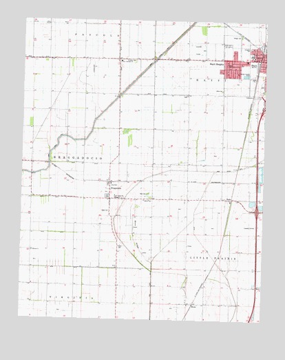
Hayti Heights, MO USGS Topographic Map
Click on map above to begin viewing in our Map Viewer.

This topographic map contains these locations and features:
Feature Name Type Latitude Longitude GNIS ID View Map
BlazerPopulated PlaceN36.1831°W89.7648°740066View Map
Blow RidgeRidgeN36.1603°W89.8168°714389View Map
BraggadocioPopulated PlaceN36.1753°W89.8295°714626View Map
Braggadocio Post OfficePost OfficeN36.1758°W89.8296°2759151View Map
Braggadocio School (historical)SchoolN36.1723°W89.8168°746703View Map
Cagle CemeteryCemeteryN36.1478°W89.8262°741787View Map
Canaday Switch SchoolSchoolN36.1651°W89.7542°741789View Map
Canady SwitchLocaleN36.1645°W89.7537°736288View Map
City of Hayti HeightsCivilN36.2312°W89.7682°2394337View Map
Cupp CemeteryCemeteryN36.1781°W89.8098°716600View Map
Darnell CemeteryCemeteryN36.1748°W89.8117°716674View Map
Ditch Number 12CanalN36.2356°W89.8259°736273View Map
Ditch Number 15CanalN36.1465°W89.8729°755061View Map
Ditch Number 18CanalN36.1901°W89.8418°755067View Map
Ditch Number 20CanalN36.2190°W89.8073°755075View Map
Ditch Number 21CanalN36.2337°W89.7873°755077View Map
Ditch Number 4CanalN36.1584°W89.7823°755108View Map
DulandLocaleN36.2045°W89.7601°740411View Map
Elk Chute (historical)CanalN36.2220°W89.8395°739541View Map
Erwin (historical)LocaleN36.1576°W89.7620°740410View Map
Evergreen CemeteryCemeteryN36.2387°W89.7584°717686View Map
FarisPopulated PlaceN36.1856°W89.7987°737966View Map
GillPopulated PlaceN36.2192°W89.7895°718442View Map
Grassy BayouLocaleN36.1473°W89.7767°741788View Map
Hatley CemeteryCemeteryN36.1703°W89.8298°719206View Map
Hayti HeightsPopulated PlaceN36.2340°W89.7695°719269View Map
Hayti Heights Fire DepartmentBuildingN36.2323°W89.7700°2621659View Map
HenchleyLocaleN36.1406°W89.7801°740407View Map
Kauffman (historical)LocaleN36.2051°W89.8251°740412View Map
Littles (historical)LocaleN36.2176°W89.8576°740409View Map
Long CemeteriesCemeteryN36.1809°W89.8290°721538View Map
Main Ditch Number 6CanalN36.1534°W89.8184°755301View Map
Main Ditch Number 8CanalN36.2256°W89.8168°755302View Map
MicolaPopulated PlaceN36.1317°W89.7859°731617View Map
Morgan CemeteryCemeteryN36.2434°W89.7629°722610View Map
Pemiscot CountyCivilN36.2115°W89.7854°758532View Map
Pemiscot County Farm (historical)LocaleN36.2331°W89.8223°1669623View Map
Pemiscot County Special SchoolSchoolN36.1759°W89.8270°743103View Map
Pemiscot County Vocational SchoolSchoolN36.2331°W89.8248°766174View Map
Pemiscot Memorial GardensCemeteryN36.1755°W89.7503°724192View Map
Pullam CemeteryCemeteryN36.1559°W89.8237°724987View Map
Saint Johns CemeteryCemeteryN36.2334°W89.8170°725768View Map
ShadePopulated PlaceN36.1756°W89.7667°726228View Map
South SchoolSchoolN36.2337°W89.7501°726784View Map
Spear School (historical)SchoolN36.1937°W89.7898°746705View Map
StrotherLocaleN36.2051°W89.8654°740408View Map
Township of HaytiCivilN36.2232°W89.7544°767144View Map
VicksburgPopulated PlaceN36.1540°W89.8701°730286View Map
Vicksburg ChurchChurchN36.1537°W89.8690°728182View Map
Vicksburg SchoolSchoolN36.1545°W89.8704°746704View Map
White CemeteryCemeteryN36.2209°W89.7723°728712View Map

Note: Coordinates in the location and feature list above are referenced to NAD83 datum.


Copyright (C) 2008-2024 Ryan Niemi / Sunset Dynamics ... All Rights Reserved