TopoQuest Logo
Do you find TopoQuest useful?
Help keep TopoQuest running and adding new maps/features by donating!
Bitcoin:  19c7KJd3qBynnjoSw5npx9KScwjBe4ifkT
Litecoin:  LXs6TkuXGGXo1vDsWCkWVdjQX94eUKd6ui
Home View Maps Find Maps Find Places Resources & Links


Averill, Michigan Topographic Map

USGS Map Title: Averill, MI
USGS Map MRC: 43084F3
DRG (GeoTIFF) Download: o43084f3.tif


Neighboring USGS Topographic Map Quads:


  Edenville, MI  
43084G4
 

  Hope, MI  
43084G3
 

  Estey, MI  
43084G2
 

  Sanford, MI  
43084F4
 

  Averill, MI  
43084F3
 

  Midland North, MI  
43084F2
 

  Floyd, MI  
43084E4
 

  Gordonville, MI  
43084E3
 

  Midland South, MI  
43084E2


Map MRC Location:

N44°
W85°
N44°
W84°
H8 H7 H6 H5 H4 H3 H2 H1
G8 G7 G6 G5 G4 G3 G2 G1
F8 F7 F6 F5 F4 F3 F2 F1
E8 E7 E6 E5 E4 E3 E2 E1
D8 D7 D6 D5 D4 D3 D2 D1
C8 C7 C6 C5 C4 C3 C2 C1
B8 B7 B6 B5 B4 B3 B2 B1
A8 A7 A6 A5 A4 A3 A2 A1
N43°
W85°
N43°
W84°

Averill, MI USGS 1:24K Topographic Map Preview:
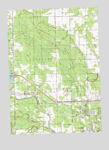
Averill, MI USGS Topographic Map
Click on map above to begin viewing in our Map Viewer.

This topographic map contains these locations and features:
Feature Name Type Latitude Longitude GNIS ID View Map
Abundant Life ChurchChurchN43.6767°W84.3692°2544653View Map
Alpine Mobile Home VillagePopulated PlaceN43.6639°W84.2683°2544182View Map
AverillPopulated PlaceN43.6656°W84.3419°620375View Map
Averill ChurchChurchN43.6703°W84.3086°620376View Map
Averill CreekStreamN43.6620°W84.3508°620377View Map
Averill Post Office (historical)Post OfficeN43.6656°W84.3419°2544225View Map
Averill Station (historical)LocaleN43.6642°W84.3417°2544190View Map
Bennett Sports CenterBuildingN43.6275°W84.2722°2544137View Map
Bensch DrainCanalN43.6742°W84.3019°621125View Map
BombayPopulated PlaceN43.7417°W84.2664°1617453View Map
Boyle DrainCanalN43.7453°W84.2708°621824View Map
Calvary Baptist AcademySchoolN43.6533°W84.2764°2544165View Map
Calvary Baptist ChurchChurchN43.6533°W84.2764°2542580View Map
Calvary CemeteryCemeteryN43.7439°W84.2555°622478View Map
Carrol Creek DrainStreamN43.6300°W84.3217°622784View Map
Christian SchoolSchoolN43.6547°W84.2811°623259View Map
Clark DrainCanalN43.7314°W84.3025°623349View Map
Cook Elementary School ParkParkN43.6478°W84.2756°2544103View Map
Cook SchoolSchoolN43.6475°W84.2739°623746View Map
Dempski DrainStreamN43.6831°W84.2528°624545View Map
Dittmar DrainCanalN43.6970°W84.3247°624703View Map
Dow High SchoolSchoolN43.6403°W84.2747°624838View Map
DuBois DormsBuildingN43.6294°W84.2811°2544144View Map
Glencoe ParkParkN43.6436°W84.2622°2544101View Map
Grass CreekStreamN43.7086°W84.3050°627170View Map
Gray Post Office (historical)Post OfficeN43.7139°W84.2889°2544215View Map
Hach Student Activity CenterBuildingN43.6278°W84.2736°2544138View Map
Hahn DrainCanalN43.6650°W84.2794°627602View Map
Heritage ParkParkN43.6278°W84.2658°2544107View Map
Holy Scripture Lutheran ChurchChurchN43.6289°W84.2656°2542716View Map
Huron ParkParkN43.6444°W84.2839°2544104View Map
Inman DrainCanalN43.6625°W84.3153°629047View Map
Irish Reed DrainCanalN43.6509°W84.3714°629069View Map
Jack Barstow AirportAirportN43.6606°W84.2620°1624042View Map
Jacobs DrainStreamN43.6572°W84.2678°629188View Map
Jerome Township Fire Department Station 2BuildingN43.7000°W84.3689°2626824View Map
Jordan HallBuildingN43.6289°W84.2758°2544139View Map
Kelly DrainCanalN43.7470°W84.2975°629544View Map
Lalkwood ParkParkN43.6536°W84.2539°2544105View Map
Larkin CemeteryCemeteryN43.6881°W84.2664°630164View Map
Lighthouse Bible Baptist ChurchChurchN43.6678°W84.3708°2544644View Map
Lincoln Township Fire DepartmentBuildingN43.6667°W84.3392°2626777View Map
Memorial Gardens CemeteryCemeteryN43.6306°W84.3703°632087View Map
Meridian Church of GodChurchN43.6739°W84.3686°2544649View Map
Meridian Elementary SchoolSchoolN43.7097°W84.3694°2544651View Map
Meridian High SchoolSchoolN43.7069°W84.3694°2544650View Map
Meridian Junior High SchoolSchoolN43.7117°W84.3703°2544652View Map
Meridian SchoolSchoolN43.7097°W84.3686°632121View Map
Michigan Department of Natural Resources Sanford Field OfficeBuildingN43.6694°W84.3724°2627033View Map
Mid Michigan Physicians GroupHospitalN43.6372°W84.2597°2544157View Map
Midland Baha'i CommunityChurchN43.6522°W84.2825°2542609View Map
Midland County FairgroundsLocaleN43.6603°W84.2533°2544174View Map
Midland Municipal CemeteryCemeteryN43.6292°W84.2542°2544596View Map
MidMichigan Medical Center - MidlandHospitalN43.6353°W84.2605°2544169View Map
MidMichigan Medical Center Emergency Medical Services Station 8BuildingN43.6396°W84.2621°2662013View Map
MidMichigan Medical Center Emergency Medical Services Station 9BuildingN43.7000°W84.3689°2661906View Map
Miller DrainStreamN43.7184°W84.2550°632373View Map
Miner HallBuildingN43.6286°W84.2794°2544143View Map
Mount Hope Fellowship ChurchChurchN43.7167°W84.3147°2544657View Map
Newell DrainStreamN43.6761°W84.2711°633359View Map
Northwest ParkParkN43.6603°W84.2681°2544099View Map
Northwood UniversitySchoolN43.6300°W84.2789°633733View Map
Old Bombay CemeteryCemeteryN43.7420°W84.2814°633987View Map
Old Oak Trails Estates Mobile Home ParkPopulated PlaceN43.6583°W84.3222°2544622View Map
Open Door Baptist ChurchChurchN43.6542°W84.2667°2542601View Map
Perkins SchoolSchoolN43.7022°W84.3681°634657View Map
R Gary Stauffer Academic BuildingBuildingN43.6306°W84.2758°2544142View Map
River Bend ParkParkN43.6442°W84.3203°635955View Map
Saint Mary's ParkParkN43.6494°W84.2583°2544100View Map
Saint Paul Lutheran ChurchChurchN43.6706°W84.3736°2544648View Map
Saint Paul SchoolSchoolN43.6706°W84.3733°636999View Map
Sanford First Baptist ChurchChurchN43.7031°W84.3681°637238View Map
Sanford Oil FieldOilfieldN43.6931°W84.3708°1623617View Map
School House DrainCanalN43.7472°W84.3069°637371View Map
Sterns DrainCanalN43.6784°W84.3142°638804View Map
Strosacker LibraryBuildingN43.6286°W84.2767°2544140View Map
Sturgeon CreekStreamN43.6278°W84.2622°638986View Map
Sturgeon Creek ParkParkN43.6433°W84.2692°2544102View Map
Temple Beth-ElChurchN43.6494°W84.2881°2542610View Map
Tendercare Midland Nursing HomeHospitalN43.6425°W84.2842°2544168View Map
Township of LincolnCivilN43.6993°W84.3291°1626623View Map
Valley ParkParkN43.6311°W84.2597°2544106View Map
Village ApartmentsBuildingN43.6286°W84.2697°2544136View Map
Wesley ChapelChurchN43.6461°W84.2775°2542581View Map
Woodcrest SchoolSchoolN43.6481°W84.2589°1616742View Map

Note: Coordinates in the location and feature list above are referenced to NAD83 datum.


Copyright (C) 2008-2024 Ryan Niemi / Sunset Dynamics ... All Rights Reserved