TopoQuest Logo
Do you find TopoQuest useful?
Help keep TopoQuest running and adding new maps/features by donating!
Bitcoin:  19c7KJd3qBynnjoSw5npx9KScwjBe4ifkT
Litecoin:  LXs6TkuXGGXo1vDsWCkWVdjQX94eUKd6ui
Home View Maps Find Maps Find Places Resources & Links


Harris, Missouri Topographic Map

USGS Map Title: Harris, MO
USGS Map MRC: 40093C3
DRG (GeoTIFF) Download: o40093c3.tif


Neighboring USGS Topographic Map Quads:


  Ravanna, MO  
40093D4
 

  Lucerne, MO  
40093D3
 

  Pollock NW, MO  
40093D2
 

  Half Rock, MO  
40093C4
 

  Harris, MO  
40093C3
 

  Pollock SW, MO  
40093C2
 

  Galt, MO  
40093B4
 

  Osgood, MO  
40093B3
 

  Milan West, MO  
40093B2


Map MRC Location:

N41°
W94°
N41°
W93°
H8 H7 H6 H5 H4 H3 H2 H1
G8 G7 G6 G5 G4 G3 G2 G1
F8 F7 F6 F5 F4 F3 F2 F1
E8 E7 E6 E5 E4 E3 E2 E1
D8 D7 D6 D5 D4 D3 D2 D1
C8 C7 C6 C5 C4 C3 C2 C1
B8 B7 B6 B5 B4 B3 B2 B1
A8 A7 A6 A5 A4 A3 A2 A1
N40°
W94°
N40°
W93°

Harris, MO USGS 1:24K Topographic Map Preview:
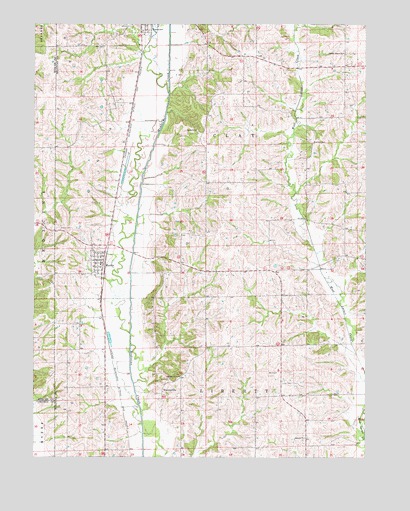
Harris, MO USGS Topographic Map
Click on map above to begin viewing in our Map Viewer.

This topographic map contains these locations and features:
Feature Name Type Latitude Longitude GNIS ID View Map
Asbury ChurchChurchN40.2556°W93.2727°713416View Map
Brackett CemeteryCemeteryN40.3408°W93.2708°714606View Map
Busby CemeteryCemeteryN40.3442°W93.3155°715102View Map
Center Grove ChurchChurchN40.3667°W93.2591°715638View Map
Center Grove School (historical)SchoolN40.3664°W93.2560°733898View Map
Colfax School (historical)SchoolN40.3225°W93.3094°733901View Map
Enterprise School (historical)SchoolN40.3650°W93.3022°733899View Map
Griffith School (historical)SchoolN40.2747°W93.2841°733902View Map
HarrisPopulated PlaceN40.3058°W93.3502°719142View Map
Harris CemeteryCemeteryN40.3161°W93.3669°719148View Map
Harris Fire DepartmentBuildingN40.3063°W93.3508°2620907View Map
Hooton CreekStreamN40.3550°W93.3260°719783View Map
Jones School (historical)SchoolN40.3547°W93.3583°733896View Map
Pine School (historical)SchoolN40.2703°W93.3616°733897View Map
Reed School (historical)SchoolN40.3286°W93.2610°733900View Map
Town of HarrisCivilN40.3061°W93.3504°2396987View Map
Township of ClayCivilN40.3405°W93.2815°767443View Map
Township of LibertyCivilN40.2531°W93.2818°767446View Map
WintersvillePopulated PlaceN40.2683°W93.3269°741368View Map
Wintersville CemeteryCemeteryN40.2725°W93.3247°729015View Map
Wintersville School (historical)SchoolN40.2814°W93.3072°733903View Map

Note: Coordinates in the location and feature list above are referenced to NAD83 datum.


Copyright (C) 2008-2024 Ryan Niemi / Sunset Dynamics ... All Rights Reserved