TopoQuest Logo
Do you find TopoQuest useful?
Help keep TopoQuest running and adding new maps/features by donating!
Bitcoin:  19c7KJd3qBynnjoSw5npx9KScwjBe4ifkT
Litecoin:  LXs6TkuXGGXo1vDsWCkWVdjQX94eUKd6ui
Home View Maps Find Maps Find Places Resources & Links


Avant, Oklahoma Topographic Map

USGS Map Title: Avant, OK
USGS Map MRC: 36096D1
DRG (GeoTIFF) Download: o36096d1.tif


Neighboring USGS Topographic Map Quads:


  Barnsdall, OK  
36096E2
 

  Wolco, OK  
36096E1
 

  Ramona, OK  
36095E8
 

  Avant NW, OK  
36096D2
 

  Avant, OK  
36096D1
 

  Vera, OK  
36095D8
 

  Avant SW, OK  
36096C2
 

  Avant SE, OK  
36096C1
 

  Sperry, OK  
36095C8


Map MRC Location:

N37°
W97°
N37°
W96°
H8 H7 H6 H5 H4 H3 H2 H1
G8 G7 G6 G5 G4 G3 G2 G1
F8 F7 F6 F5 F4 F3 F2 F1
E8 E7 E6 E5 E4 E3 E2 E1
D8 D7 D6 D5 D4 D3 D2 D1
C8 C7 C6 C5 C4 C3 C2 C1
B8 B7 B6 B5 B4 B3 B2 B1
A8 A7 A6 A5 A4 A3 A2 A1
N36°
W97°
N36°
W96°

Avant, OK USGS 1:24K Topographic Map Preview:
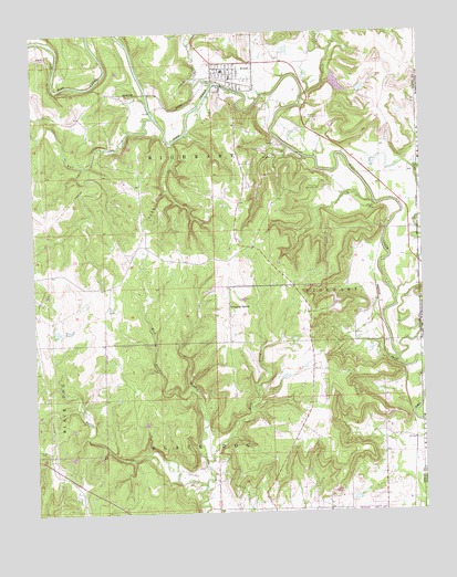
Avant, OK USGS Topographic Map
Click on map above to begin viewing in our Map Viewer.

This topographic map contains these locations and features:
Feature Name Type Latitude Longitude GNIS ID View Map
AvantPopulated PlaceN36.4895°W96.0622°1089765View Map
Avant CemeteryCemeteryN36.4988°W96.0677°1089766View Map
Avant Elementary SchoolSchoolN36.4900°W96.0637°1790552View Map
Avant Fire DepartmentBuildingN36.4878°W96.0611°2657345View Map
Avant Oil FieldOilfieldN36.4626°W96.0792°1089767View Map
Avant Police DepartmentBuildingN36.4886°W96.0609°2757623View Map
Avant Water Supply LakeReservoirN36.4866°W96.0263°1751139View Map
Avant Water Supply Lake DamDamN36.4886°W96.0282°1751138View Map
Battle CreekStreamN36.3815°W96.0714°1089886View Map
Bull CreekStreamN36.4781°W96.0861°1090678View Map
Candy CreekStreamN36.4826°W96.0389°1090899View Map
Candy Lake Estate AirportAirportN36.4868°W96.0522°2676483View Map
Clem CreekStreamN36.4904°W96.1178°1091451View Map
Dripping SpringLocaleN36.4287°W96.0628°1092191View Map
East Prong Quapaw CreekStreamN36.3884°W96.0711°1092431View Map
Javine Oil FieldOilfieldN36.3823°W96.0681°1094182View Map
Lombard CemeteryCemeteryN36.4591°W96.0326°1094887View Map
Oknoname 113005 DamDamN36.4868°W96.0419°1754022View Map
Oknoname 113005 ReservoirReservoirN36.4868°W96.0419°1754023View Map
Oknoname 113068 DamDamN36.4218°W96.1186°1754024View Map
Oknoname 113068 ReservoirReservoirN36.4227°W96.1183°1754025View Map
Oknoname 113069 DamDamN36.4234°W96.1153°1754026View Map
Oknoname 113069 ReservoirReservoirN36.4227°W96.1144°1754027View Map
Oknoname 113070 DamDamN36.4284°W96.1003°1754028View Map
Oknoname 113070 ReservoirReservoirN36.4284°W96.1007°1754029View Map
Skiatook Oil FieldOilfieldN36.4118°W96.0264°1098095View Map
Town of AvantCivilN36.4886°W96.0599°2411654View Map
Tucker CreekStreamN36.4870°W96.0669°1098998View Map
Tyner CreekStreamN36.4154°W96.0086°1099135View Map
West Prong Quapaw CreekStreamN36.4076°W96.0750°1099596View Map

Note: Coordinates in the location and feature list above are referenced to NAD83 datum.


Copyright (C) 2008-2024 Ryan Niemi / Sunset Dynamics ... All Rights Reserved