TopoQuest Logo
Do you find TopoQuest useful?
Help keep TopoQuest running and adding new maps/features by donating!
Bitcoin:  19c7KJd3qBynnjoSw5npx9KScwjBe4ifkT
Litecoin:  LXs6TkuXGGXo1vDsWCkWVdjQX94eUKd6ui
Home View Maps Find Maps Find Places Resources & Links


Auvergne, Arkansas Topographic Map

USGS Map Title: Auvergne, AR
USGS Map MRC: 35091E2
DRG (GeoTIFF) Download: o35091e2.tif


Neighboring USGS Topographic Map Quads:


  Jacksonport, AR  
35091F3
 

  Tuckerman, AR  
35091F2
 

  Grubbs, AR  
35091F1
 

  Newport, AR  
35091E3
 

  Auvergne, AR  
35091E2
 

  Amagon, AR  
35091E1
 

  Augusta NE, AR  
35091D3
 

  Tupelo, AR  
35091D2
 

  Beedeville, AR  
35091D1


Map MRC Location:

N36°
W92°
N36°
W91°
H8 H7 H6 H5 H4 H3 H2 H1
G8 G7 G6 G5 G4 G3 G2 G1
F8 F7 F6 F5 F4 F3 F2 F1
E8 E7 E6 E5 E4 E3 E2 E1
D8 D7 D6 D5 D4 D3 D2 D1
C8 C7 C6 C5 C4 C3 C2 C1
B8 B7 B6 B5 B4 B3 B2 B1
A8 A7 A6 A5 A4 A3 A2 A1
N35°
W92°
N35°
W91°

Auvergne, AR USGS 1:24K Topographic Map Preview:
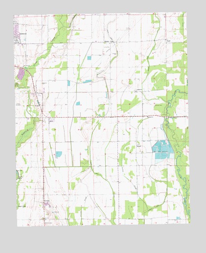
Auvergne, AR USGS Topographic Map
Click on map above to begin viewing in our Map Viewer.

This topographic map contains these locations and features:
Feature Name Type Latitude Longitude GNIS ID View Map
AuvergnePopulated PlaceN35.5137°W91.2307°57295View Map
Browns Creek DitchCanalN35.6126°W91.1468°47024View Map
Church of ChristChurchN35.5015°W91.2298°47775View Map
City of NewportCivilN35.6242°W91.2317°2404372View Map
Cypress Creek DitchCanalN35.5092°W91.1515°48312View Map
ErwinPopulated PlaceN35.5620°W91.2260°57727View Map
Erwin Volunteer Fire DepartmentBuildingN35.5644°W91.2287°2116407View Map
Haigwood Landing StripAirportN35.6112°W91.2419°2650803View Map
Jackson CountyCivilN35.5992°W91.2146°66861View Map
JohnstownPopulated PlaceN35.5784°W91.1626°57070View Map
Johnstown CemeteriesCemeteryN35.5698°W91.1496°50708View Map
Lampkins CemeteryCemeteryN35.6012°W91.1762°50968View Map
Leachville CemeteryCemeteryN35.5951°W91.2435°51021View Map
Locust CreekStreamN35.6181°W91.2143°51368View Map
Locust Creek DitchCanalN35.5537°W91.1951°51371View Map
Mayberry SloughGutN35.5548°W91.2423°51759View Map
Murphys CornerPopulated PlaceN35.6081°W91.1848°77785View Map
Murphys Corner Baptist ChurchChurchN35.6073°W91.1812°63149View Map
RemmelPopulated PlaceN35.5470°W91.1632°78162View Map
Rutherford SchoolSchoolN35.5637°W91.1546°54295View Map
Saint Lukes ChurchChurchN35.5717°W91.2321°54389View Map
Sand Hill CemeteryCemeteryN35.5046°W91.2311°54539View Map
StegallPopulated PlaceN35.6073°W91.1401°55199View Map
Township of CacheCivilN35.5225°W91.1654°66722View Map
Turkey SloughStreamN35.5079°W91.1557°55731View Map
Wilkerson CemeteryCemeteryN35.5845°W91.2304°56378View Map

Note: Coordinates in the location and feature list above are referenced to NAD83 datum.


Copyright (C) 2008-2024 Ryan Niemi / Sunset Dynamics ... All Rights Reserved