TopoQuest Logo
Do you find TopoQuest useful?
Help keep TopoQuest running and adding new maps/features by donating!
Bitcoin:  19c7KJd3qBynnjoSw5npx9KScwjBe4ifkT
Litecoin:  LXs6TkuXGGXo1vDsWCkWVdjQX94eUKd6ui
Home View Maps Find Maps Find Places Resources & Links


Half Dome, California Topographic Map

USGS Map Title: Half Dome, CA
USGS Map MRC: 37119F5
DRG (GeoTIFF) Download: o37119f5.tif


Neighboring USGS Topographic Map Quads:


  Tamarack Flat, CA  
37119G6
 

  Yosemite Falls, CA  
37119G5
 

  Tenaya Lake, CA  
37119G4
 

  El Capitan, CA  
37119F6
 

  Half Dome, CA  
37119F5
 

  Merced Peak, CA  
37119F4
 

  Wawona, CA  
37119E6
 

  Mariposa Grove, CA  
37119E5
 

  Sing Peak, CA  
37119E4


Map MRC Location:

N38°
W120°
N38°
W119°
H8 H7 H6 H5 H4 H3 H2 H1
G8 G7 G6 G5 G4 G3 G2 G1
F8 F7 F6 F5 F4 F3 F2 F1
E8 E7 E6 E5 E4 E3 E2 E1
D8 D7 D6 D5 D4 D3 D2 D1
C8 C7 C6 C5 C4 C3 C2 C1
B8 B7 B6 B5 B4 B3 B2 B1
A8 A7 A6 A5 A4 A3 A2 A1
N37°
W120°
N37°
W119°

Half Dome, CA USGS 1:24K Topographic Map Preview:
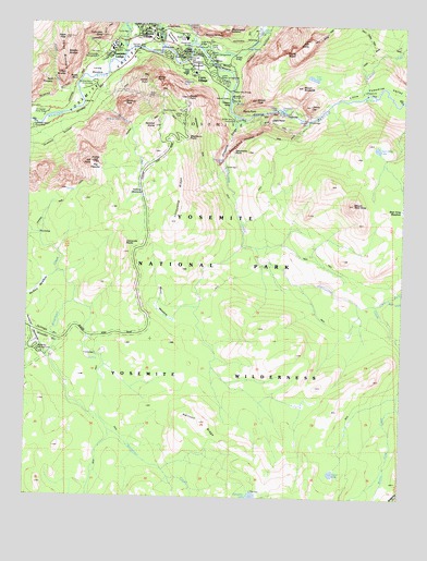
Half Dome, CA USGS Topographic Map
Click on map above to begin viewing in our Map Viewer.

This topographic map contains these locations and features:
Feature Name Type Latitude Longitude GNIS ID View Map
Ahwahnee BridgeBridgeN37.7441°W119.5732°253035View Map
Ahwahnee MeadowFlatN37.7466°W119.5802°252483View Map
Bridalveil CampgroundLocaleN37.6622°W119.6207°253423View Map
Buena Vista CreekStreamN37.6677°W119.5027°257645View Map
Buena Vista TrailTrailN37.7099°W119.5652°253426View Map
Camp Curry Historic DistrictParkN37.7366°W119.5718°1809275View Map
Camp Curry Post Office (historical)Post OfficeN37.7366°W119.5718°1940059View Map
Cathedral Beach Picnic AreaLocaleN37.7246°W119.6224°253036View Map
Clark ForkStreamN37.6763°W119.5096°254747View Map
Clark Fork Illilouette CreekStreamN37.6760°W119.5107°2014006View Map
Clark PointSummitN37.7241°W119.5452°253037View Map
Clarks BridgeBridgeN37.7396°W119.5649°253038View Map
Columbia RockPillarN37.7466°W119.6029°254767View Map
Curry VillageLocaleN37.7369°W119.5727°1658360View Map
Curry Village Post Office (historical)Post OfficeN37.7369°W119.5727°1940070View Map
Delaware North Company Fire Department YosemiteBuildingN37.7480°W119.5860°2624251View Map
Diving BoardCliffN37.7424°W119.5410°253457View Map
Eagle CreekStreamN37.7327°W119.6104°253702View Map
Eagle PeakSummitN37.7461°W119.6148°1658452View Map
Edson LakeLakeN37.6316°W119.5236°253461View Map
Emerald PoolLakeN37.7277°W119.5424°253729View Map
Four Mile TrailTrailN37.7324°W119.5813°253040View Map
Glacier PointCliffN37.7308°W119.5738°253478View Map
Grizzly PeakSummitN37.7300°W119.5505°1658676View Map
Group CampLocaleN37.7441°W119.5641°253041View Map
Half DomeSummitN37.7444°W119.5341°253497View Map
Happy IslesIslandN37.7299°W119.5591°253500View Map
Happy Isles BridgeBridgeN37.7327°W119.5585°253042View Map
Hoover CreekStreamN37.6494°W119.5021°261453View Map
Horizon RidgeRidgeN37.6448°W119.5670°225583View Map
Housekeeping CampLocaleN37.7416°W119.5799°253043View Map
Illilouette CreekStreamN37.7258°W119.5568°261689View Map
Illilouette FallsFallsN37.7138°W119.5618°254807View Map
Illilouette GorgeValleyN37.7254°W119.5559°254808View Map
Illilouette RidgeRidgeN37.6977°W119.5781°254809View Map
Indian Canyon CreekStreamN37.7438°W119.5818°254810View Map
Iron SpringSpringN37.7438°W119.5538°254820View Map
Leconte Memorial LodgeBuildingN37.7395°W119.5792°2542538View Map
Leidig MeadowFlatN37.7380°W119.6038°254906View Map
Liberty CapSummitN37.7286°W119.5325°254909View Map
Little Yosemite ValleyValleyN37.7258°W119.5293°255105View Map
Lost Bear MeadowFlatN37.6491°W119.5988°254942View Map
Lost LakeLakeN37.7358°W119.5318°252484View Map
Lower BrotherPillarN37.7363°W119.6143°253530View Map
Lower Pines CampgroundLocaleN37.7408°W119.5677°253044View Map
Lower River CampgroundLocaleN37.7416°W119.5763°253045View Map
Medial MoraineRidgeN37.7380°W119.5575°1667951View Map
Middle BrotherPillarN37.7419°W119.6141°253546View Map
Mirror LakeLakeN37.7486°W119.5488°253549View Map
Mist TrailTrailN37.7269°W119.5454°253046View Map
Mono MeadowFlatN37.6755°W119.5827°253551View Map
Mono Meadow TrailTrailN37.6844°W119.5549°253552View Map
Moran PointSummitN37.7354°W119.5843°1659173View Map
Mount BroderickSummitN37.7335°W119.5351°254663View Map
Mount Starr KingSummitN37.7028°W119.5176°253928View Map
Nevada FallFallsN37.7252°W119.5338°254969View Map
North Pines CampgroundLocaleN37.7419°W119.5666°253047View Map
Ostrander RocksSummitN37.6928°W119.5935°255003View Map
Panorama CliffCliffN37.7202°W119.5535°253737View Map
Panorama PointSummitN37.7165°W119.5573°1654900View Map
Panorama TrailTrailN37.7149°W119.5599°253048View Map
Peregoy MeadowFlatN37.6677°W119.6232°253747View Map
Pohono MeadowFlatN37.6583°W119.5843°252204View Map
Pothole MeadowsFlatN37.7046°W119.5896°253786View Map
Profile CliffCliffN37.7133°W119.6049°253792View Map
Rangers' ClubBuildingN37.7474°W119.5867°2559458View Map
Red CreekStreamN37.6777°W119.5052°255025View Map
Rocky PointSlopeN37.7349°W119.6129°255046View Map
Roosevelt PointCapeN37.7228°W119.5934°2711981View Map
Royal Arch CascadeFallsN37.7496°W119.5707°255055View Map
Royal Arch CreekStreamN37.7449°W119.5721°255056View Map
Royal ArchesPillarN37.7466°W119.5663°255057View Map
Sentinel Beach Picnic AreaLocaleN37.7346°W119.6049°253049View Map
Sentinel BridgeBridgeN37.7433°W119.5902°253050View Map
Sentinel CreekStreamN37.7355°W119.6049°253837View Map
Sentinel DomeSummitN37.7230°W119.5843°253838View Map
Sentinel FallFallsN37.7249°W119.5966°253839View Map
Sentinel RockPillarN37.7288°W119.5943°253840View Map
Sierra PointSummitN37.7276°W119.5551°253852View Map
Silver ApronFallsN37.7269°W119.5407°252485View Map
Split PinnaclePillarN37.7341°W119.6191°253602View Map
Staircase FallsFallsN37.7352°W119.5749°253925View Map
Starr King LakeLakeN37.7174°W119.5097°253926View Map
Starr King MeadowFlatN37.7030°W119.5004°253927View Map
Stoneman BridgeBridgeN37.7405°W119.5738°253051View Map
Stoneman MeadowFlatN37.7405°W119.5707°1667952View Map
Sugar Pine BridgeBridgeN37.7444°W119.5699°253052View Map
Sunnyside CampgroundLocaleN37.7416°W119.6035°253053View Map
Sunrise CreekStreamN37.7321°W119.5135°253614View Map
Taft PointSummitN37.7127°W119.6049°1659945View Map
Tenaya BridgeBridgeN37.7419°W119.5579°253054View Map
Tenaya CanyonValleyN37.7407°W119.5593°252478View Map
Tenaya CreekStreamN37.7433°W119.5685°255124View Map
The AhwahneeBuildingN37.7463°W119.5743°253412View Map
The FissuresCliffN37.7124°W119.6038°255132View Map
Three BrothersSummitN37.7460°W119.6148°1659995View Map
Union PointSummitN37.7345°W119.5875°1660081View Map
Upper Pines CampgroundLocaleN37.7360°W119.5635°253055View Map
Upper River CampgroundLocaleN37.7430°W119.5738°253056View Map
Vernal FallFallsN37.7288°W119.5462°255195View Map
Washburn PointSummitN37.7202°W119.5731°253627View Map
Washington ColumnPillarN37.7485°W119.5599°255218View Map
Yosemite CreekStreamN37.7424°W119.5946°253968View Map
Yosemite LodgeLocaleN37.7433°W119.5985°253057View Map
Yosemite Lodge Post Office (historical)Post OfficeN37.7430°W119.5982°1940046View Map
Yosemite National Park Post OfficePost OfficeN37.7486°W119.5880°1809303View Map
Yosemite National Park Valley Elementary SchoolSchoolN37.7488°W119.5911°253058View Map
Yosemite Valley Census Designated PlaceCensusN37.7408°W119.5779°2409638View Map
Yosemite Valley DivisionCivilN37.7114°W119.5762°1935386View Map
Yosemite VillageLocaleN37.7452°W119.5982°1660219View Map

Note: Coordinates in the location and feature list above are referenced to NAD83 datum.


Copyright (C) 2008-2024 Ryan Niemi / Sunset Dynamics ... All Rights Reserved