TopoQuest Logo
Do you find TopoQuest useful?
Help keep TopoQuest running and adding new maps/features by donating!
Bitcoin:  19c7KJd3qBynnjoSw5npx9KScwjBe4ifkT
Litecoin:  LXs6TkuXGGXo1vDsWCkWVdjQX94eUKd6ui
Home View Maps Find Maps Find Places Resources & Links


Grove, Oklahoma Topographic Map

USGS Map Title: Grove, OK
USGS Map MRC: 36094E7
DRG (GeoTIFF) Download: o36094e7.tif


Neighboring USGS Topographic Map Quads:


  Afton, OK  
36094F8
 

  Afton NE, OK  
36094F7
 

  Cayuga, OK  
36094F6
 

  Bernice, OK  
36094E8
 

  Grove, OK  
36094E7
 

  Dodge, OK  
36094E6
 

  Chloeta, OK  
36094D8
 

  Jay, OK  
36094D7
 

  Sycamore, OK  
36094D6


Map MRC Location:

N37°
W95°
N37°
W94°
H8 H7 H6 H5 H4 H3 H2 H1
G8 G7 G6 G5 G4 G3 G2 G1
F8 F7 F6 F5 F4 F3 F2 F1
E8 E7 E6 E5 E4 E3 E2 E1
D8 D7 D6 D5 D4 D3 D2 D1
C8 C7 C6 C5 C4 C3 C2 C1
B8 B7 B6 B5 B4 B3 B2 B1
A8 A7 A6 A5 A4 A3 A2 A1
N36°
W95°
N36°
W94°

Grove, OK USGS 1:24K Topographic Map Preview:
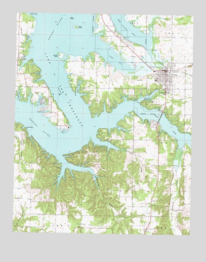
Grove, OK USGS Topographic Map
Click on map above to begin viewing in our Map Viewer.

This topographic map contains these locations and features:
Feature Name Type Latitude Longitude GNIS ID View Map
Albert Lodge HeliportAirportN36.5417°W94.8336°1102487View Map
Bad IslandIslandN36.6223°W94.8369°1089782View Map
Baptist First Southern ChurchChurchN36.5940°W94.7697°1798240View Map
Buzzard CemeteryCemeteryN36.6120°W94.7997°1090757View Map
Carey BayBayN36.5987°W94.8041°1090961View Map
Chigger CoveBayN36.5781°W94.8727°1091286View Map
Christian First ChurchChurchN36.5926°W94.7711°1798241View Map
Church of ChristChurchN36.5865°W94.7708°1798242View Map
City of GroveCivilN36.5925°W94.7886°2410667View Map
Cornerstone ChurchChurchN36.5829°W94.7608°1798243View Map
Courthouse HollowValleyN36.5542°W94.8186°1091758View Map
Courthouse PrairieFlatN36.5048°W94.8230°1091759View Map
Delaware ChurchChurchN36.5023°W94.7822°1092029View Map
DennisCivilN36.5433°W94.8693°2631096View Map
Dennis Census Designated PlaceCensusN36.5433°W94.8693°2408659View Map
Dilar CoveBayN36.5601°W94.8002°1092087View Map
Elm CreekStreamN36.5751°W94.7883°1092579View Map
Flatrock HollowValleyN36.5795°W94.8308°1092891View Map
Grace Presbyterian ChurchChurchN36.5948°W94.7697°1798244View Map
Grand Lake O' the CherokeesReservoirN36.6127°W94.8629°1102836View Map
Grand Lake Regional AirportAirportN36.5825°W94.8615°2676468View Map
GrovePopulated PlaceN36.5937°W94.7691°1093427View Map
Grove DivisionCivilN36.5885°W94.7970°1937720View Map
Grove Emergency Medical ServicesBuildingN36.5817°W94.7694°2695820View Map
Grove Fire DepartmentBuildingN36.5947°W94.7689°2656907View Map
Grove General Hospital HeliportAirportN36.5834°W94.7669°1102486View Map
Grove Lower Elementary SchoolSchoolN36.5879°W94.7762°2712993View Map
Grove Middle SchoolSchoolN36.5872°W94.7797°1793688View Map
Grove Police DepartmentBuildingN36.5937°W94.7686°2757464View Map
Grove Primary SchoolSchoolN36.5873°W94.7697°1793689View Map
Grove Upper Elementary SchoolSchoolN36.5888°W94.7754°2713031View Map
Honey Creek Recreation AreaParkN36.5756°W94.7838°1093887View Map
Integris Grove General HospitalHospitalN36.5823°W94.7706°2695801View Map
Isles' End CoveBayN36.5740°W94.8580°1094137View Map
KGVE-FM (Grove)TowerN36.6137°W94.7650°1102256View Map
Monkey Island Fire AssociationBuildingN36.5905°W94.8667°2657414View Map
New Life Assembly of God ChurchChurchN36.5956°W94.7722°1798245View Map
Patricia IslandIslandN36.6012°W94.8430°1096462View Map
Rolston CemeteryCemeteryN36.5965°W94.8741°1097403View Map
Spring BranchStreamN36.6067°W94.7827°1098373View Map
Stoney PointCapeN36.5592°W94.8675°1098562View Map
Sweetwater PrairieFlatN36.5187°W94.8700°1098697View Map
Tauuneacie CemeteryCemeteryN36.5167°W94.7786°1098765View Map
Teramiranda Airport (historical)AirportN36.6084°W94.8725°1102347View Map
Weed IslandIslandN36.6173°W94.8330°1099469View Map
Whitewater CreekStreamN36.5495°W94.7580°1099737View Map
Woodward HollowValleyN36.5431°W94.8427°1100008View Map
ZenaCivilN36.5129°W94.8454°2631205View Map
Zena CemeteryCemeteryN36.5029°W94.8297°1100071View Map
Zena Census Designated PlaceCensusN36.5129°W94.8454°2409644View Map
Zena Volunteer Fire Department Station 1BuildingN36.5252°W94.8738°2656864View Map
Zena Volunteer Fire Department Station 2BuildingN36.5046°W94.8275°2657267View Map

Note: Coordinates in the location and feature list above are referenced to NAD83 datum.


Copyright (C) 2008-2024 Ryan Niemi / Sunset Dynamics ... All Rights Reserved