TopoQuest Logo
Do you find TopoQuest useful?
Help keep TopoQuest running and adding new maps/features by donating!
Bitcoin:  19c7KJd3qBynnjoSw5npx9KScwjBe4ifkT
Litecoin:  LXs6TkuXGGXo1vDsWCkWVdjQX94eUKd6ui
Home View Maps Find Maps Find Places Resources & Links


Augusta, Michigan Topographic Map

USGS Map Title: Augusta, MI
USGS Map MRC: 42085C3
DRG (GeoTIFF) Download: o42085c3.tif


Neighboring USGS Topographic Map Quads:


  Delton, MI  
42085D4
 

  Banfield, MI  
42085D3
 

  Bedford, MI  
42085D2
 

  Galesburg, MI  
42085C4
 

  Augusta, MI  
42085C3
 

  Battle Creek, MI  
42085C2
 

  Adams Park, MI  
42085B4
 

  Climax, MI  
42085B3
 

  East Leroy, MI  
42085B2


Map MRC Location:

N43°
W86°
N43°
W85°
H8 H7 H6 H5 H4 H3 H2 H1
G8 G7 G6 G5 G4 G3 G2 G1
F8 F7 F6 F5 F4 F3 F2 F1
E8 E7 E6 E5 E4 E3 E2 E1
D8 D7 D6 D5 D4 D3 D2 D1
C8 C7 C6 C5 C4 C3 C2 C1
B8 B7 B6 B5 B4 B3 B2 B1
A8 A7 A6 A5 A4 A3 A2 A1
N42°
W86°
N42°
W85°

Augusta, MI USGS 1:24K Topographic Map Preview:
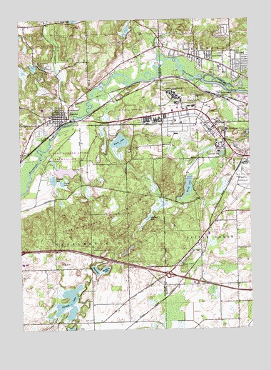
Augusta, MI USGS Topographic Map
Click on map above to begin viewing in our Map Viewer.

This topographic map contains these locations and features:
Feature Name Type Latitude Longitude GNIS ID View Map
Arcadian Oak Mobile Home ParkPopulated PlaceN42.3258°W85.2519°2630079View Map
AugustaPopulated PlaceN42.3364°W85.3522°620342View Map
Augusta CemeteryCemeteryN42.3397°W85.3569°2627928View Map
Augusta CreekStreamN42.3331°W85.3483°620343View Map
Augusta Fellowship United Methodist ChurchChurchN42.3356°W85.3519°2627907View Map
Augusta Police DepartmentBuildingN42.3343°W85.3525°2737612View Map
Augusta Post OfficePost OfficeN42.3350°W85.3519°2627902View Map
Augusta StationLocaleN42.3333°W85.3525°2627898View Map
Augusta Village HallBuildingN42.3347°W85.3519°2627903View Map
Avenue A Mobile Home EstatesPopulated PlaceN42.3258°W85.2511°2630080View Map
Barn Theatre Historical MarkerParkN42.3254°W85.3735°2611915View Map
Battle Creek Veterans Affairs Medical CenterHospitalN42.3435°W85.2913°1615563View Map
Bedford CemeteryCemeteryN42.3436°W85.2783°620983View Map
Bedford Station Post Office (historical)Post OfficeN42.3478°W85.2800°2630178View Map
Bedford Township Police DepartmentBuildingN42.3589°W85.2788°2737422View Map
Bible Baptist ChurchChurchN42.3347°W85.3567°2627906View Map
Buffalo CampgroundLocaleN42.2708°W85.2769°2629495View Map
Burnham LakeLakeN42.2736°W85.3317°622291View Map
Cedar Creek Golf CourseLocaleN42.2728°W85.2750°2629492View Map
Charter Township of Bedford Fire Department Station 2BuildingN42.3589°W85.2788°2635999View Map
Cold Brook ParkParkN42.2533°W85.3467°2627891View Map
Covey Hill CemeteryCemeteryN42.3175°W85.2528°2574960View Map
Custer Air Force Station (historical)MilitaryN42.3436°W85.2778°2087520View Map
Custer Greens Golf CourseLocaleN42.3222°W85.2931°2629487View Map
Custer Main HeliportAirportN42.3317°W85.2967°1623795View Map
Department of Veterans Affairs Fire DepartmentBuildingN42.3416°W85.2884°2636244View Map
Eagle LakeLakeN42.3259°W85.3207°625083View Map
Fort Custer National CemeteryCemeteryN42.3392°W85.3175°2500657View Map
Fort Custer State ParkParkN42.3117°W85.3175°626295View Map
Fort Custer Training CenterMilitaryN42.2926°W85.3259°2512191View Map
Galesburg-Augusta Intermediate SchoolSchoolN42.3363°W85.3606°2627894View Map
Galesburg-Augusta Middle SchoolSchoolN42.3389°W85.3625°2627905View Map
Harts LakeLakeN42.3078°W85.2837°627889View Map
Interchange 92CrossingN42.2722°W85.2953°2628032View Map
Lawler CemeteryCemeteryN42.3050°W85.3469°630207View Map
Lawler LakeLakeN42.3089°W85.3522°630208View Map
Lawrence LakeLakeN42.3206°W85.2651°630215View Map
Level ParkPopulated PlaceN42.3603°W85.2725°630338View Map
Level Park-Oak Park Census Designated PlaceCensusN42.3642°W85.2665°2393099View Map
Martin SchoolSchoolN42.2817°W85.2800°631668View Map
McKay's Memorial LibraryBuildingN42.3350°W85.3517°2627904View Map
Michigan Air National Guard Fire Department Battle CreekBuildingN42.3111°W85.2566°2636043View Map
North CemeteryCemeteryN42.2539°W85.3369°633555View Map
Oak ParkPopulated PlaceN42.3584°W85.2569°633850View Map
Park Theatre Historical MarkerParkN42.3344°W85.3518°2611914View Map
Portage LakeLakeN42.2540°W85.3526°635278View Map
Post CemeteryCemeteryN42.3359°W85.3214°635321View Map
Sevenmile CreekStreamN42.3606°W85.2992°637597View Map
Shady Bend CampgroundLocaleN42.3478°W85.3306°2627900View Map
Springbrook Golf CourseLocaleN42.3278°W85.2569°2630081View Map
Stonehedge Golf CourseLocaleN42.3694°W85.3342°2627899View Map
Suburban Medical CenterHospitalN42.3342°W85.3522°2627901View Map
Township of CharlestonCivilN42.2892°W85.3552°1626059View Map
Union Pump Company Historical MarkerParkN42.3350°W85.2701°2628088View Map
Veterans Hospital Number 100 Historical MarkerParkN42.3339°W85.2970°2628089View Map
Village of AugustaCivilN42.3379°W85.3525°2398009View Map
W K Kellogg Experimental ForestForestN42.3667°W85.3528°2627893View Map
Wabascon CreekStreamN42.3506°W85.2750°1615640View Map
Whitford LakeLakeN42.3098°W85.3558°1616376View Map
Whitman LakeLakeN42.2951°W85.3053°1616380View Map
WKFR-FM (Battle Creek)TowerN42.3553°W85.3411°1625654View Map
Wood LakeLakeN42.2739°W85.3347°1616725View Map

Note: Coordinates in the location and feature list above are referenced to NAD83 datum.


Copyright (C) 2008-2024 Ryan Niemi / Sunset Dynamics ... All Rights Reserved