TopoQuest Logo
Do you find TopoQuest useful?
Help keep TopoQuest running and adding new maps/features by donating!
Bitcoin:  19c7KJd3qBynnjoSw5npx9KScwjBe4ifkT
Litecoin:  LXs6TkuXGGXo1vDsWCkWVdjQX94eUKd6ui
Home View Maps Find Maps Find Places Resources & Links


Auburntown, Tennessee Topographic Map

USGS Map Title: Auburntown, TN
USGS Map MRC: 35086H1
DRG (GeoTIFF) Download: o35086h1.tif


Neighboring USGS Topographic Map Quads:


  Watertown, TN  
36086A2
 

  Alexandria, TN  
36086A1
 

  Liberty, TN  
36085A8
 

  Milton, TN  
35086H2
 

  Auburntown, TN  
35086H1
 

  Gassaway, TN  
35085H8
 

  Readyville, TN  
35086G2
 

  Woodbury, TN  
35086G1
 

  Short Mountain, TN  
35085G8


Map MRC Location:

N36°
W87°
N36°
W86°
H8 H7 H6 H5 H4 H3 H2 H1
G8 G7 G6 G5 G4 G3 G2 G1
F8 F7 F6 F5 F4 F3 F2 F1
E8 E7 E6 E5 E4 E3 E2 E1
D8 D7 D6 D5 D4 D3 D2 D1
C8 C7 C6 C5 C4 C3 C2 C1
B8 B7 B6 B5 B4 B3 B2 B1
A8 A7 A6 A5 A4 A3 A2 A1
N35°
W87°
N35°
W86°

Auburntown, TN USGS 1:24K Topographic Map Preview:
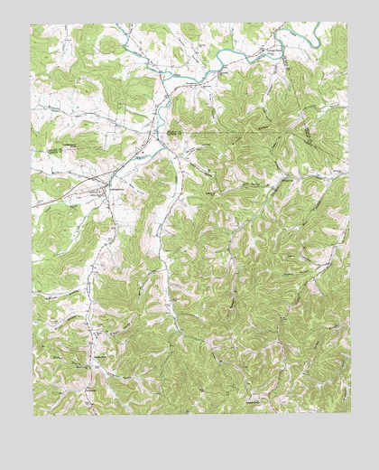
Auburntown, TN USGS Topographic Map
Click on map above to begin viewing in our Map Viewer.

This topographic map contains these locations and features:
Feature Name Type Latitude Longitude GNIS ID View Map
Alexander HollowValleyN35.8929°W86.1011°1275560View Map
Anderson CemeteryCemeteryN35.9903°W86.0292°1275706View Map
Anderson HollowValleyN35.9873°W86.0288°1304833View Map
Auburn Elementary SchoolSchoolN35.9453°W86.0978°1648225View Map
Auburn High School (historical)SchoolN35.9490°W86.0972°1643498View Map
AuburntownPopulated PlaceN35.9476°W86.0972°1304896View Map
Auburntown Post OfficePost OfficeN35.9478°W86.0961°1650160View Map
Auburntown Volunteer Fire DepartmentBuildingN35.9489°W86.0944°2654800View Map
Blair BranchStreamN35.9495°W86.0061°1277636View Map
Bogle CemeteryCemeteryN35.8859°W86.1167°1643507View Map
Brandon CemeteryCemeteryN35.9206°W86.1000°1643514View Map
Bryson BranchStreamN35.8915°W86.1019°1278763View Map
Bryson CemeteryCemeteryN35.9034°W86.1000°1278764View Map
Bryson HollowValleyN35.8912°W86.1026°1643518View Map
Bryson RidgeRidgeN35.9642°W86.0394°1278769View Map
BrysonvillePopulated PlaceN35.8834°W86.1039°1314755View Map
Carter CreekStreamN35.9448°W86.0953°1279812View Map
Commissioner District 2CivilN35.8967°W86.0425°2463901View Map
Cooper CemeteryCemeteryN35.9042°W86.1169°1281197View Map
Cottage HomePopulated PlaceN35.9909°W86.0333°1281351View Map
Davenport CemeteryCemeteryN35.8820°W86.1175°1643533View Map
Davenport CemeteryCemeteryN35.8762°W86.1197°1643534View Map
Donnell CemeteryCemeteryN35.9428°W86.1225°1282637View Map
Duggin CemeteryCemeteryN35.8906°W86.1008°1283103View Map
Duggin CemeteryCemeteryN35.9348°W86.0917°1643541View Map
Duggin HollowValleyN35.9022°W86.1011°1283104View Map
Dutton HollowValleyN35.9508°W86.0244°1647252View Map
Fite CemeteryCemeteryN35.9726°W86.0517°1323171View Map
Fite HollowValleyN35.9794°W86.0544°1284333View Map
Fodderstack KnobSummitN35.9609°W86.1067°1284542View Map
Gaither HollowValleyN35.9576°W86.0647°1285075View Map
Gann HollowValleyN35.9221°W86.0116°1285132View Map
Groom CemeteryCemeteryN35.9767°W86.0105°2712040View Map
HardscrabblePopulated PlaceN35.8937°W86.1019°1315191View Map
Harvey HollowValleyN35.9970°W86.0863°1287076View Map
Hatley CemeteryCemeteryN35.9656°W86.0442°1323183View Map
Hawkins HillSummitN35.9451°W86.0528°1287188View Map
Hawkins HollowValleyN35.9572°W86.0652°1287189View Map
Higgins HollowValleyN35.8842°W86.0112°1647253View Map
Hurricane CreekStreamN35.9603°W86.0725°1288797View Map
Jewel HollowValleyN35.9509°W86.0894°1289422View Map
Jones CemeteryCemeteryN35.8817°W86.0742°1289737View Map
Jones ChapelChurchN35.8803°W86.0900°1643576View Map
Jones Chapel (historical)Populated PlaceN35.8823°W86.0736°1643575View Map
Jones School (historical)SchoolN35.8806°W86.0903°1309967View Map
Keaton HollowValleyN35.9593°W86.0298°1289925View Map
Kennedy CemeteryCemeteryN35.9928°W86.0592°1290072View Map
Kennedy CreekStreamN35.9698°W86.0747°1290075View Map
Leach CreekStreamN35.9434°W86.0972°1290858View Map
Lick BranchStreamN35.9506°W86.0242°1291178View Map
Marshall CreekStreamN35.9484°W86.0947°1292765View Map
McKnight BranchStreamN35.9151°W86.1033°1293391View Map
Milligan Alexander CemeteryCemeteryN35.9201°W86.1028°1643593View Map
Mingle BranchStreamN35.9062°W86.1030°1294043View Map
Missionary ChurchChurchN35.9467°W86.0989°1294083View Map
Missionary ChurchChurchN35.9798°W86.0578°1294084View Map
Mount Pleasant Baptist Church (historical)ChurchN35.8812°W86.0250°1643597View Map
North Cannon Division (historical)CensusN35.8898°W86.0672°1648624View Map
Odom CemeteryCemeteryN35.9303°W86.0947°1296240View Map
Pleasant RidgePopulated PlaceN35.8798°W86.0358°1315740View Map
Pleasant Ridge Church of ChristChurchN35.8790°W86.0389°1643611View Map
Pleasant Ridge School (historical)SchoolN35.8790°W86.0380°1322653View Map
Possum HollowValleyN35.9220°W86.0118°1298300View Map
ProsperityPopulated PlaceN35.9803°W86.0589°1298588View Map
Prosperity ChurchChurchN35.9842°W86.0511°1298593View Map
Prosperity School (historical)SchoolN35.9795°W86.0569°1323235View Map
Pugh HollowValleyN35.9744°W86.0337°1298658View Map
Purtle CreekStreamN35.9917°W86.0453°1298710View Map
Reed CemeteryCemeteryN35.8789°W86.1028°1299132View Map
Sanders Fork School (historical)SchoolN35.8890°W86.1014°1322654View Map
Saunders ForkStreamN35.9834°W86.0697°1300809View Map
Saunders Fork Baptist ChurchChurchN35.8906°W86.1039°1300810View Map
Shiloh Baptist ChurchChurchN35.9015°W86.1000°1303583View Map
Shirley HollowValleyN35.9209°W86.0741°1270133View Map
Smith HollowValleyN35.8970°W86.0375°1647258View Map
Spout Spring BranchStreamN35.9462°W86.0294°1303753View Map
StringtownPopulated PlaceN35.9490°W86.0275°1314349View Map
Sycamore Baptist ChurchChurchN35.9517°W86.0028°1303978View Map
Sycamore School (historical)SchoolN35.9526°W86.0019°1643647View Map
Sycamore School (historical)SchoolN35.9398°W86.0347°1651948View Map
Talent HollowValleyN35.9852°W86.0548°1272044View Map
Town of AuburntownCivilN35.9497°W86.1014°2405184View Map
Willard CemeteryCemeteryN35.8820°W86.0572°1274609View Map
Willow Swamp School (historical)SchoolN35.9098°W86.1028°1309973View Map
Womack School (historical)SchoolN35.9017°W86.0458°1309974View Map

Note: Coordinates in the location and feature list above are referenced to NAD83 datum.


Copyright (C) 2008-2024 Ryan Niemi / Sunset Dynamics ... All Rights Reserved