TopoQuest Logo
Do you find TopoQuest useful?
Help keep TopoQuest running and adding new maps/features by donating!
Bitcoin:  19c7KJd3qBynnjoSw5npx9KScwjBe4ifkT
Litecoin:  LXs6TkuXGGXo1vDsWCkWVdjQX94eUKd6ui
Home View Maps Find Maps Find Places Resources & Links


Grays Peak, Colorado Topographic Map

USGS Map Title: Grays Peak, CO
USGS Map MRC: 39105F7
DRG (GeoTIFF) Download: o39105f7.tif


Neighboring USGS Topographic Map Quads:


  Byers Peak, CO  
39105G8
 

  Berthoud Pass, CO  
39105G7
 

  Empire, CO  
39105G6
 

  Loveland Pass, CO  
39105F8
 

  Grays Peak, CO  
39105F7
 

  Georgetown, CO  
39105F6
 

  Keystone, CO  
39105E8
 

  Montezuma, CO  
39105E7
 

  Mount Evans, CO  
39105E6


Map MRC Location:

N40°
W106°
N40°
W105°
H8 H7 H6 H5 H4 H3 H2 H1
G8 G7 G6 G5 G4 G3 G2 G1
F8 F7 F6 F5 F4 F3 F2 F1
E8 E7 E6 E5 E4 E3 E2 E1
D8 D7 D6 D5 D4 D3 D2 D1
C8 C7 C6 C5 C4 C3 C2 C1
B8 B7 B6 B5 B4 B3 B2 B1
A8 A7 A6 A5 A4 A3 A2 A1
N39°
W106°
N39°
W105°

Grays Peak, CO USGS 1:24K Topographic Map Preview:
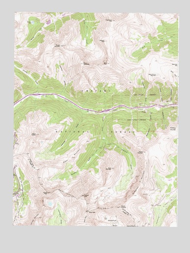
Grays Peak, CO USGS Topographic Map
Click on map above to begin viewing in our Map Viewer.

This topographic map contains these locations and features:
Feature Name Type Latitude Longitude GNIS ID View Map
A Tunnel MineMineN39.6580°W105.7600°1693686View Map
Aldrich MineMineN39.6730°W105.7781°1693687View Map
AP Tunnel MineMineN39.6711°W105.7972°1693688View Map
Arapaho Basin Ski AreaLocaleN39.6436°W105.8731°169499View Map
Argentine MineMineN39.6455°W105.7631°1693689View Map
Argentine PassGapN39.6253°W105.7825°202858View Map
Atlantis MineMineN39.6592°W105.7817°1693690View Map
B Tunnel MineMineN39.6586°W105.7617°1693691View Map
Baker MountainSummitN39.6653°W105.8306°181832View Map
BakervillePopulated PlaceN39.6914°W105.8050°196497View Map
Bard PeakSummitN39.7203°W105.8039°181861View Map
Big Boy MineMineN39.6878°W105.7856°1693692View Map
Big Chief MineMineN39.6525°W105.7622°1693693View Map
Booster MineMineN39.6992°W105.7825°1693694View Map
Broken Handle MineMineN39.6592°W105.7839°1693684View Map
Brown MountainSummitN39.7078°W105.7508°202853View Map
Bryan Tunnel MineMineN39.6489°W105.7608°1693695View Map
Celestine MineMineN39.7133°W105.7525°1693696View Map
Climax MineMineN39.6861°W105.7586°1693697View Map
Cloud GulchValleyN39.6959°W105.7599°181863View Map
Continental MountainsRangeN39.6338°W105.8174°2761777View Map
Coo Coo MineMineN39.6686°W105.7842°1693698View Map
Deadman GulchValleyN39.6949°W105.7598°181839View Map
Decatur MinesMineN39.6344°W105.8220°1693730View Map
Dewey Tunnel MineMineN39.6583°W105.7667°1693699View Map
Dry GulchValleyN39.6966°W105.8739°181806View Map
Eagles Nest MineMineN39.6436°W105.8095°1693700View Map
Elizabeth MineMineN39.6644°W105.7975°1693701View Map
Emperor Tunnel MineMineN39.6375°W105.7789°1693702View Map
Engelmann PeakSummitN39.7455°W105.8006°181858View Map
Esperanza MineMineN39.6983°W105.7570°1693703View Map
Front RangeRangeN39.6339°W105.8175°170426View Map
Ganley MountainSummitN39.6689°W105.7764°181837View Map
Gold Belt MineMineN39.6922°W105.7739°1693683View Map
Golden Belt MineMineN39.6922°W105.7742°1693704View Map
Golden Belt TunnelTunnelN39.6919°W105.7742°181840View Map
GraymontPopulated PlaceN39.6944°W105.8006°181852View Map
Grays LakeLakeN39.6295°W105.8034°2722796View Map
Grays PeakSummitN39.6339°W105.8175°181827View Map
Grays Peak TrailTrailN39.6414°W105.8111°181830View Map
Great East Tunnel MineMineN39.6711°W105.7878°1693705View Map
Great Grizzley Gulch MineMineN39.6678°W105.8108°1693706View Map
Grizzly GulchValleyN39.6761°W105.8067°181849View Map
Grizzly PeakSummitN39.6444°W105.8486°181826View Map
Grizzly TunnelMineN39.6705°W105.8061°181848View Map
Hamill MineMineN39.6917°W105.7714°181841View Map
Harrower MineMineN39.6986°W105.7817°1693707View Map
Hassell LakeLakeN39.7440°W105.8612°181857View Map
Herman GulchValleyN39.7035°W105.8569°181807View Map
Hidden Treasure MineMineN39.6367°W105.7783°1693708View Map
Johnny Bull MineMineN39.6958°W105.7531°181842View Map
Johnny Bull MineMineN39.6961°W105.7528°1693709View Map
Joseph MineMineN39.6647°W105.8006°1693710View Map
Josephine MineMineN39.6728°W105.8011°181847View Map
Josephine MineMineN39.6544°W105.7822°1693711View Map
Junction Finder MineMineN39.6630°W105.7986°1693712View Map
Kearney GulchValleyN39.6913°W105.8220°181853View Map
Kelso Group MineMineN39.6678°W105.8072°1693713View Map
Kelso MountainSummitN39.6589°W105.8003°181831View Map
Kent MineMineN39.6692°W105.8097°1693714View Map
King Albert MineMineN39.6997°W105.7570°1693715View Map
L M MineMineN39.6997°W105.7595°1693717View Map
Laura MineMineN39.6717°W105.8028°1693716View Map
Lenawee MountainSummitN39.6300°W105.8556°202855View Map
Lower Urad DamDamN39.7433°W105.8306°198568View Map
Lower Urad ReservoirReservoirN39.7433°W105.8306°198569View Map
McClellan MountainRidgeN39.6517°W105.7781°181834View Map
McClellan Mountain MineMineN39.6592°W105.7700°1735435View Map
Mother MineMineN39.6900°W105.7703°1693718View Map
Mount EdwardsSummitN39.6364°W105.7939°181828View Map
Mount MachebeufSummitN39.7230°W105.8578°196614View Map
Mount ParnassusSummitN39.7200°W105.8225°181860View Map
Mount SniktauSummitN39.6783°W105.8578°181854View Map
Newcastle MineMineN39.6675°W105.8083°1693719View Map
Pendleton MountainSummitN39.6825°W105.7514°202854View Map
Pinkerton GulchValleyN39.6969°W105.7551°181845View Map
Pomeroy MineMineN39.6714°W105.7986°1693720View Map
Quayle CreekStreamN39.6917°W105.8058°181851View Map
Robeson PeakSummitN39.7336°W105.8061°181859View Map
San Juan TunnelMineN39.6717°W105.8081°181846View Map
Santiago MineMineN39.6436°W105.7736°181835View Map
Santiago MineMineN39.6436°W105.7733°1735436View Map
Silver Cloud MineMineN39.6986°W105.7592°181843View Map
Silver Plume MountainSummitN39.7139°W105.7670°181864View Map
Silver Wind One MineMineN39.6769°W105.8064°1693721View Map
Silver Wind Three MineMineN39.6769°W105.8064°1693723View Map
Silver Wind Two MineMineN39.6769°W105.8064°1693722View Map
Smith Tunnel MineMineN39.6528°W105.7617°1693724View Map
Sophy MineMineN39.6997°W105.7583°1693725View Map
Sterling Silver Group MineMineN39.6580°W105.7925°1693726View Map
Stevens GulchValleyN39.6761°W105.8066°181850View Map
Stevens MineMineN39.6547°W105.7822°181833View Map
Sussex MineMineN39.6678°W105.8061°1693727View Map
Thompson GulchValleyN39.6954°W105.7765°181862View Map
Tobin Group MineMineN39.6555°W105.7675°1693728View Map
Torreys PeakSummitN39.6428°W105.8214°181829View Map
Upper Urad DamDamN39.7500°W105.8489°198570View Map
Upper Urad ReservoirReservoirN39.7500°W105.8489°198571View Map
Vidler MineMineN39.6322°W105.7581°1693729View Map
W and M MineMineN39.6969°W105.7806°181844View Map
Waldorf MineMineN39.6375°W105.7675°181836View Map
Watrous GulchValleyN39.7017°W105.8402°181855View Map
West Terrible MineMineN39.6964°W105.7503°1693936View Map
Wide-awake GulchValleyN39.6926°W105.7717°181838View Map
Woods MountainSummitN39.7222°W105.8397°181856View Map

Note: Coordinates in the location and feature list above are referenced to NAD83 datum.


Copyright (C) 2008-2024 Ryan Niemi / Sunset Dynamics ... All Rights Reserved