TopoQuest Logo
Do you find TopoQuest useful?
Help keep TopoQuest running and adding new maps/features by donating!
Bitcoin:  19c7KJd3qBynnjoSw5npx9KScwjBe4ifkT
Litecoin:  LXs6TkuXGGXo1vDsWCkWVdjQX94eUKd6ui
Home View Maps Find Maps Find Places Resources & Links


Gordonville, Texas Topographic Map

USGS Map Title: Gordonville, TX
USGS Map MRC: 33096G7
DRG (GeoTIFF) Download: o33096g7.tif


Neighboring USGS Topographic Map Quads:


  Lebanon, OK  
33096H8
 

  Shay, OK  
33096H7
 

  Kingston South, OK  
33096H6
 

  Dexter, TX  
33096G8
 

  Gordonville, TX  
33096G7
 

  Pottsboro, TX  
33096G6
 

  Whitesboro, TX  
33096F8
 

  Sadler, TX  
33096F7
 

  Sherman NW, TX  
33096F6


Map MRC Location:

N34°
W97°
N34°
W96°
H8 H7 H6 H5 H4 H3 H2 H1
G8 G7 G6 G5 G4 G3 G2 G1
F8 F7 F6 F5 F4 F3 F2 F1
E8 E7 E6 E5 E4 E3 E2 E1
D8 D7 D6 D5 D4 D3 D2 D1
C8 C7 C6 C5 C4 C3 C2 C1
B8 B7 B6 B5 B4 B3 B2 B1
A8 A7 A6 A5 A4 A3 A2 A1
N33°
W97°
N33°
W96°

Gordonville, TX USGS 1:24K Topographic Map Preview:
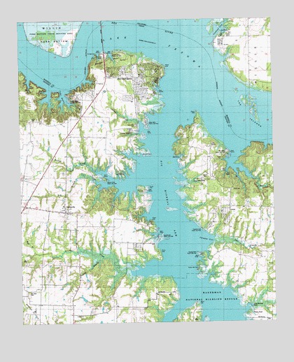
Gordonville, TX USGS Topographic Map
Click on map above to begin viewing in our Map Viewer.

This topographic map contains these locations and features:
Feature Name Type Latitude Longitude GNIS ID View Map
Big Mineral ArmBayN33.7718°W96.7969°1352103View Map
Brushy Creek AirportAirportN33.7531°W96.8320°2675858View Map
Camp GraysonLocaleN33.8234°W96.7808°1889629View Map
Camp KadohadachoLocaleN33.8090°W96.7878°1889628View Map
Camp Rio RoxoLocaleN33.8112°W96.8247°1353667View Map
Camp TexomaLocaleN33.8112°W96.7703°1353682View Map
Cardinal CoveBayN33.8709°W96.7594°1777495View Map
Cardinal Cove Fire DistrictBuildingN33.8642°W96.7738°2657153View Map
Cedar BayouLakeN33.8418°W96.8542°1354031View Map
Cedar Bayou Publice Use AreaParkN33.8418°W96.8475°1889620View Map
Cedar CreekStreamN33.8287°W96.8133°1354062View Map
Cedar MillsPopulated PlaceN33.8287°W96.8197°1354132View Map
Cedar Mills AirportAirportN33.8382°W96.8133°2675815View Map
Cedar Mills Public Use AreasParkN33.8326°W96.8128°1889623View Map
Copper BranchStreamN33.7765°W96.8356°1354968View Map
Cross Timbers Hiking TrailTrailN33.8401°W96.8464°2032895View Map
Dead Woman PondLakeN33.7567°W96.7620°1889626View Map
Dry BranchStreamN33.8068°W96.8339°1356281View Map
Flowing Wells Public Use AreaParkN33.7782°W96.7875°1889957View Map
Fobb BottomFlatN33.8709°W96.8572°1777493View Map
GordonvillePopulated PlaceN33.7957°W96.8531°1358189View Map
Gordonville Volunteer Fire DepartmentBuildingN33.7976°W96.8545°2551573View Map
Johnson CemeteryCemeteryN33.8432°W96.8145°2773415View Map
Juniper PointCapeN33.8418°W96.8253°1377761View Map
Juniper Point Public Use AreaParkN33.8607°W96.8283°1889621View Map
Lake TexomaReservoirN33.7705°W96.8195°1102966View Map
Liberty CemeteryCemeteryN33.8329°W96.8678°1361149View Map
LocustPopulated PlaceN33.7973°W96.7725°1380097View Map
Locust CemeteryCemeteryN33.8045°W96.7708°1889631View Map
Locust Community Volunteer Fire DepartmentBuildingN33.7966°W96.7740°2551508View Map
Mill CreekStreamN33.8201°W96.7692°1362876View Map
Mill Creek Public Use AreaParkN33.8209°W96.7733°1889630View Map
Mount Tabor CemeteryCemeteryN33.7620°W96.8719°1363322View Map
Noel CemeteryCemeteryN33.8590°W96.8247°1889622View Map
North Branch Brushy CreekStreamN33.7732°W96.8081°1363999View Map
Northwest Grayson DivisionCivilN33.7521°W96.7852°1939049View Map
Paradise CoveBayN33.7843°W96.7800°1364802View Map
Paradise Cove Public Use AreaParkN33.7882°W96.7858°1889627View Map
Picnic PondLakeN33.7531°W96.7614°1889625View Map
Red BranchStreamN33.7782°W96.8689°1366134View Map
Samuels CampLocaleN33.8201°W96.8131°1890020View Map
Sandusky Oil FieldOilfieldN33.7562°W96.8725°1889996View Map
Sandy CreekStreamN33.7598°W96.7953°1367718View Map
Scott BranchStreamN33.7837°W96.7764°1367878View Map
Sherwood Shore Volunteer Fire DepartmentBuildingN33.8501°W96.8280°2551451View Map
Sherwood ShoresPopulated PlaceN33.8562°W96.8211°2034680View Map
Sherwood ShoresPopulated PlaceN33.8523°W96.8178°1889619View Map
Sherwood Shores Census Designated PlaceCensusN33.8478°W96.8147°2586990View Map
The IslandsIslandN33.8390°W96.7600°1777492View Map
Walnut CreekStreamN33.8101°W96.8319°1370809View Map
Walnut Creek Public Use AreaParkN33.8095°W96.8339°1889624View Map

Note: Coordinates in the location and feature list above are referenced to NAD83 datum.


Copyright (C) 2008-2024 Ryan Niemi / Sunset Dynamics ... All Rights Reserved