TopoQuest Logo
Do you find TopoQuest useful?
Help keep TopoQuest running and adding new maps/features by donating!
Bitcoin:  19c7KJd3qBynnjoSw5npx9KScwjBe4ifkT
Litecoin:  LXs6TkuXGGXo1vDsWCkWVdjQX94eUKd6ui
Home View Maps Find Maps Find Places Resources & Links


Astico, Wisconsin Topographic Map

USGS Map Title: Astico, WI
USGS Map MRC: 43088C8
DRG (GeoTIFF) Download: o43088c8.tif


Neighboring USGS Topographic Map Quads:


  Fall River, WI  
43089D1
 

  Lost Lake, WI  
43088D8
 

  Beaver Dam, WI  
43088D7
 

  Columbus, WI  
43089C1
 

  Astico, WI  
43088C8
 

  Reeseville, WI  
43088C7
 

  Marshall, WI  
43089B1
 

  Waterloo, WI  
43088B8
 

  Richwood, WI  
43088B7


Map MRC Location:

N44°
W89°
N44°
W88°
H8 H7 H6 H5 H4 H3 H2 H1
G8 G7 G6 G5 G4 G3 G2 G1
F8 F7 F6 F5 F4 F3 F2 F1
E8 E7 E6 E5 E4 E3 E2 E1
D8 D7 D6 D5 D4 D3 D2 D1
C8 C7 C6 C5 C4 C3 C2 C1
B8 B7 B6 B5 B4 B3 B2 B1
A8 A7 A6 A5 A4 A3 A2 A1
N43°
W89°
N43°
W88°

Astico, WI USGS 1:24K Topographic Map Preview:
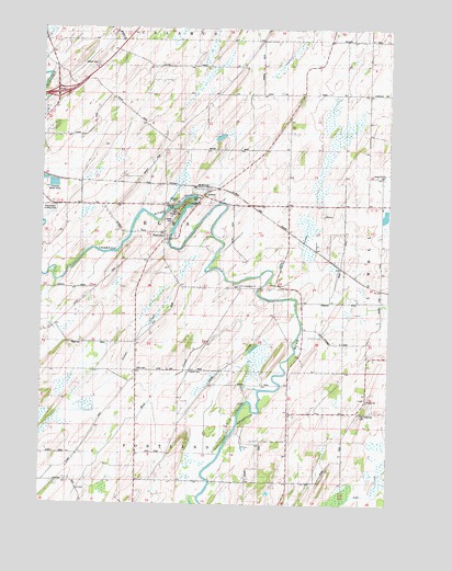
Astico, WI USGS Topographic Map
Click on map above to begin viewing in our Map Viewer.

This topographic map contains these locations and features:
Feature Name Type Latitude Longitude GNIS ID View Map
Altschwader Landing Strip (historical)AirportN43.3283°W88.9984°1850619View Map
AsticoPopulated PlaceN43.3330°W88.9398°1578571View Map
Astico County ParkParkN43.3275°W88.9509°1850623View Map
Austin CemeteryCemeteryN43.2850°W88.9464°1850625View Map
Benninger FarmsLocaleN43.2758°W88.9022°2724052View Map
Bethel CemeteryCemeteryN43.3658°W88.9801°1578573View Map
Country Gate FarmLocaleN43.3422°W88.8861°2724054View Map
DanvillePopulated PlaceN43.3194°W88.9557°1578577View Map
Danville DamDamN43.3217°W88.9534°1791902View Map
Danville Millpond 165ReservoirN43.3217°W88.9534°1791903View Map
Elba CemeteryCemeteryN43.2858°W88.9654°1578579View Map
Evangelical Reformed CemeteryCemeteryN43.2740°W88.8853°1850873View Map
Franklin School (historical)SchoolN43.3583°W88.9204°1578583View Map
Gaffney School (historical)SchoolN43.2614°W88.9546°1578584View Map
Goebel School (historical)SchoolN43.2725°W88.9098°1578585View Map
Grove Prairie CemeteryCemeteryN43.3361°W88.8776°1578586View Map
Grove Prairie School (historical)SchoolN43.3292°W88.8784°1578587View Map
Hartley School (historical)SchoolN43.3294°W88.9118°1578589View Map
Henken FarmsLocaleN43.2733°W88.8981°2724058View Map
Homestead School (historical)SchoolN43.2747°W88.8771°1578594View Map
Maiden Lane School (historical)SchoolN43.3036°W88.8779°1578601View Map
Mud CreekStreamN43.2803°W88.9215°1578604View Map
Nolan CreekStreamN43.3203°W88.9384°1578607View Map
Okeag CemeteryCemeteryN43.3250°W88.9526°1578609View Map
Pershing School (historical)SchoolN43.2917°W88.9657°1578610View Map
Pleasant Vale School (historical)SchoolN43.3280°W88.9901°1578614View Map
Saint Columbkille ChurchChurchN43.3072°W88.9287°1578618View Map
Town of ElbaCivilN43.3284°W88.9503°1583141View Map
Trinity ChurchChurchN43.2775°W88.8826°1850881View Map
Valley School (historical)SchoolN43.3678°W88.8821°1578629View Map
Wipple School (historical)SchoolN43.2553°W88.9954°1578635View Map
WYDI-TV (Fond du Lac)TowerN43.3622°W88.8959°1582495View Map

Note: Coordinates in the location and feature list above are referenced to NAD83 datum.


Copyright (C) 2008-2024 Ryan Niemi / Sunset Dynamics ... All Rights Reserved