TopoQuest Logo
Do you find TopoQuest useful?
Help keep TopoQuest running and adding new maps/features by donating!
Bitcoin:  19c7KJd3qBynnjoSw5npx9KScwjBe4ifkT
Litecoin:  LXs6TkuXGGXo1vDsWCkWVdjQX94eUKd6ui
Home View Maps Find Maps Find Places Resources & Links


Garfield, Arkansas Topographic Map

USGS Map Title: Garfield, AR
USGS Map MRC: 36093D8
DRG (GeoTIFF) Download: o36093d8.tif


Neighboring USGS Topographic Map Quads:


  Jacket, MO  
36094E1
 

  Seligman, MO  
36093E8
 

  Eagle Rock, MO  
36093E7
 

  Pea Ridge, AR  
36094D1
 

  Garfield, AR  
36093D8
 

  Beaver, AR  
36093D7
 

  Rogers, AR  
36094C1
 

  War Eagle, AR  
36093C8
 

  Sandstone Mountain, AR  
36093C7


Map MRC Location:

N37°
W94°
N37°
W93°
H8 H7 H6 H5 H4 H3 H2 H1
G8 G7 G6 G5 G4 G3 G2 G1
F8 F7 F6 F5 F4 F3 F2 F1
E8 E7 E6 E5 E4 E3 E2 E1
D8 D7 D6 D5 D4 D3 D2 D1
C8 C7 C6 C5 C4 C3 C2 C1
B8 B7 B6 B5 B4 B3 B2 B1
A8 A7 A6 A5 A4 A3 A2 A1
N36°
W94°
N36°
W93°

Garfield, AR USGS 1:24K Topographic Map Preview:
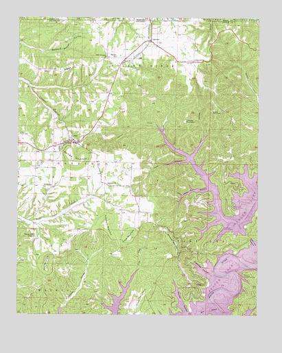
Garfield, AR USGS Topographic Map
Click on map above to begin viewing in our Map Viewer.

This topographic map contains these locations and features:
Feature Name Type Latitude Longitude GNIS ID View Map
Bayless CemeteryCemeteryN36.4830°W93.9542°75376View Map
Bayless SchoolSchoolN36.4840°W93.9496°76252View Map
Beauford Beaver HollowValleyN36.4853°W93.9869°46257View Map
ClantonvillePopulated PlaceN36.4815°W93.9091°76617View Map
Clantonville CemeteryCemeteryN36.4815°W93.9060°75440View Map
Clantonville School (historical)SchoolN36.4817°W93.9088°75441View Map
Devils Eye BrowSummitN36.4662°W93.9474°75465View Map
Devils EyebrowRidgeN36.4681°W93.9346°75466View Map
Fishtrap Ford (historical)CrossingN36.3926°W93.8974°75515View Map
Fishtrap HollowValleyN36.3923°W93.8991°76926View Map
Ford HollowValleyN36.4401°W93.9119°49155View Map
Gann RidgeRidgeN36.4827°W93.9556°76996View Map
GarfieldPopulated PlaceN36.4484°W93.9741°76997View Map
Garfield Baptist ChurchChurchN36.4501°W93.9738°75525View Map
Garfield Church of ChristChurchN36.4301°W93.9702°75526View Map
Garfield Elementary SchoolSchoolN36.4485°W93.9716°75527View Map
Garfield MountainSummitN36.4409°W93.9713°76998View Map
Garfield Post OfficePost OfficeN36.4449°W93.9903°2740122View Map
GatewayPopulated PlaceN36.4903°W93.9319°57802View Map
Gateway Assembly of God ChurchChurchN36.4937°W93.9263°75528View Map
Gateway CemeteryCemeteryN36.4929°W93.9263°2740121View Map
Gateway Post OfficePost OfficeN36.4909°W93.9311°84553View Map
Gentry MountainSummitN36.4492°W93.9544°75571View Map
Glasscock MountainSummitN36.4451°W93.9874°75532View Map
Henry MountainSummitN36.4537°W93.9946°75546View Map
Hill TopPopulated PlaceN36.4470°W93.9996°75554View Map
Hoot Owl HollowValleyN36.4284°W93.9010°50291View Map
Horn BranchStreamN36.3751°W93.9071°50321View Map
Horn HollowValleyN36.4415°W93.9099°50323View Map
Humphery MountainSummitN36.4134°W93.9552°77252View Map
Hurd (historical)Populated PlaceN36.4831°W93.9396°75563View Map
Indian Creek Public Use AreaParkN36.4206°W93.8880°77270View Map
KAMO-FM (Rogers)TowerN36.4417°W93.9741°85242View Map
KISK-FM (Lowell)TowerN36.4412°W93.9730°85218View Map
KJEM-FM (Seligman) (historical)TowerN36.4106°W93.9552°759075View Map
Limekiln HollowValleyN36.4712°W93.9944°77499View Map
Lost Bridge (historical)BridgeN36.3926°W93.8974°75601View Map
Lost Bridge Public Use AreaParkN36.4109°W93.8935°77556View Map
Lost Bridge VillagePopulated PlaceN36.3884°W93.9069°58088View Map
Lost Bridge Village AirportAirportN36.3889°W93.9097°2650762View Map
Lost Bridge Village Census Designated PlaceCensusN36.3897°W93.9156°2582917View Map
Molder HollowValleyN36.3751°W93.9069°77679View Map
Nebco Fire DepartmentBuildingN36.4438°W93.9821°2116840View Map
Nebco Fire Department Station 4BuildingN36.4794°W93.9073°2116841View Map
New Prospect Baptist ChurchChurchN36.4837°W93.9546°77837View Map
Northeast Benton County Fire Department Station 2BuildingN36.4146°W93.9361°2116873View Map
Northeast Benton County Fire Department Station 3BuildingN36.3781°W93.9623°2116874View Map
Osborn (historical)Populated PlaceN36.4815°W93.9413°75948View Map
Pond MountainSummitN36.4079°W93.9416°53681View Map
Posy MountainSummitN36.3959°W93.9852°78082View Map
Providence Primitive Baptist ChurchChurchN36.4290°W93.9871°78109View Map
Providence School (historical)SchoolN36.4259°W93.9855°75980View Map
Reddick Assembly of God ChurchChurchN36.4301°W93.9535°78227View Map
Rich MountainSummitN36.4251°W93.9294°75987View Map
Ruddick School (historical)SchoolN36.4301°W93.9535°76009View Map
Starkey HollowValleyN36.3912°W93.8846°76044View Map
Starkey Public Use AreaParkN36.3920°W93.8813°78449View Map
Sugar MountainSummitN36.4612°W93.8969°78482View Map
Taylor BranchStreamN36.4140°W93.9971°76054View Map
Town of GarfieldCivilN36.4563°W93.9755°2406542View Map
Town of GatewayCivilN36.4863°W93.9359°2406553View Map
Township 1CivilN36.4117°W93.9815°1989186View Map
Township of Garfield (historical)CivilN36.4376°W93.9835°69584View Map
Township of Pine Log (historical)CivilN36.4001°W93.8919°69593View Map
Township of Roller Ridge (historical)CivilN36.4820°W93.9085°69594View Map
Trimble MountainSummitN36.4567°W93.9133°58760View Map
Vista ShoresPopulated PlaceN36.4237°W93.9044°76075View Map
Volunteer Ambulance Service Northeast Benton CountyBuildingN36.4434°W93.9811°2119211View Map
Walnut HillPopulated PlaceN36.4084°W93.9913°76080View Map
Walnut Hill CemeteryCemeteryN36.4084°W93.9910°76101View Map
Walnut Hill Chapel Baptist ChurchChurchN36.4081°W93.9916°78685View Map
Walnut Hill School (historical)SchoolN36.4081°W93.9919°76081View Map
Whitney MountainSummitN36.4015°W93.9174°78768View Map
Williams MountainSummitN36.4587°W93.9966°76096View Map

Note: Coordinates in the location and feature list above are referenced to NAD83 datum.


Copyright (C) 2008-2024 Ryan Niemi / Sunset Dynamics ... All Rights Reserved