TopoQuest Logo
Do you find TopoQuest useful?
Help keep TopoQuest running and adding new maps/features by donating!
Bitcoin:  19c7KJd3qBynnjoSw5npx9KScwjBe4ifkT
Litecoin:  LXs6TkuXGGXo1vDsWCkWVdjQX94eUKd6ui
Home View Maps Find Maps Find Places Resources & Links


Ashmore, Illinois Topographic Map

USGS Map Title: Ashmore, IL
USGS Map MRC: 39088E1
DRG (GeoTIFF) Download: o39088e1.tif


Neighboring USGS Topographic Map Quads:


  Hindsboro, IL  
39088F2
 

  Oakland, IL  
39088F1
 

  Brocton, IL  
39087F8
 

  Charleston North, IL  
39088E2
 

  Ashmore, IL  
39088E1
 

  Kansas, IL  
39087E8
 

  Charleston South, IL  
39088D2
 

  Westfield West, IL  
39088D1
 

  Westfield East, IL  
39087D8


Map MRC Location:

N40°
W89°
N40°
W88°
H8 H7 H6 H5 H4 H3 H2 H1
G8 G7 G6 G5 G4 G3 G2 G1
F8 F7 F6 F5 F4 F3 F2 F1
E8 E7 E6 E5 E4 E3 E2 E1
D8 D7 D6 D5 D4 D3 D2 D1
C8 C7 C6 C5 C4 C3 C2 C1
B8 B7 B6 B5 B4 B3 B2 B1
A8 A7 A6 A5 A4 A3 A2 A1
N39°
W89°
N39°
W88°

Ashmore, IL USGS 1:24K Topographic Map Preview:
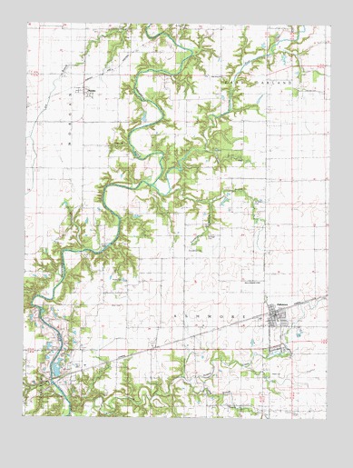
Ashmore, IL USGS Topographic Map
Click on map above to begin viewing in our Map Viewer.

This topographic map contains these locations and features:
Feature Name Type Latitude Longitude GNIS ID View Map
Airtight BridgeBridgeN39.5548°W88.0892°424558View Map
AshmorePopulated PlaceN39.5331°W88.0223°403679View Map
Ashmore Baptist ChurchChurchN39.5331°W88.0217°2043563View Map
Ashmore CemeteryCemeteryN39.5273°W88.0189°1816432View Map
Ashmore Elementary SchoolSchoolN39.5314°W88.0206°1807872View Map
Ashmore Fire Protection DistrictBuildingN39.5329°W88.0227°2682361View Map
Ashmore Post OfficePost OfficeN39.5336°W88.0219°2788202View Map
Ashmore United Presbyterian ChurchChurchN39.5325°W88.0220°2043564View Map
Barney FordCrossingN39.5520°W88.1020°422435View Map
Boneset School (historical)SchoolN39.5531°W88.0653°404682View Map
Boyd FordCrossingN39.6106°W88.0709°422491View Map
Brooks CemeteryCemeteryN39.5431°W88.0853°1721034View Map
Brush CreekStreamN39.5859°W88.0509°405020View Map
California School (historical)SchoolN39.5786°W88.1025°405363View Map
Canaan School (historical)SchoolN39.6245°W88.0639°405542View Map
Childress School (historical)SchoolN39.5681°W88.0017°406062View Map
Dudley BranchStreamN39.5111°W88.0561°407461View Map
Dudley School (historical)SchoolN39.5039°W88.0311°407462View Map
East QuarryMineN39.5314°W88.1148°1986080View Map
EmbarrassPopulated PlaceN39.5173°W88.0911°422668View Map
Enon Baptist ChurchChurchN39.5039°W88.0400°1721040View Map
Enon CemeteryCemeteryN39.5034°W88.0406°1816438View Map
Fairview CemeteryCemeteryN39.6045°W88.0111°1721041View Map
Fairview Church (historical)ChurchN39.6048°W88.0109°408195View Map
Franklin BranchStreamN39.5695°W88.0498°408657View Map
Grimm School (historical)SchoolN39.5286°W88.0523°409512View Map
Jakes BranchStreamN39.5717°W88.0667°411024View Map
John R Reed AirportAirportN39.5445°W88.0270°427026View Map
Knoch CemeteryCemeteryN39.5864°W88.0878°1721045View Map
Laffer School (historical)SchoolN39.5139°W88.0873°411688View Map
Lafler CemeteryCemeteryN39.5200°W88.1075°1721046View Map
Little Embarras RiverStreamN39.5739°W88.0745°412333View Map
Miller CemeteryCemeteryN39.5356°W88.0853°1721049View Map
Miller School (historical)SchoolN39.5348°W88.0945°413594View Map
Oak Grove Baptist ChurchChurchN39.6084°W88.0445°414789View Map
Oak Grove CemeteryCemeteryN39.6075°W88.0445°1816454View Map
Patsy Mitchell CemeteryCemeteryN39.5581°W88.0484°415437View Map
Polecat CreekStreamN39.5017°W88.1053°415985View Map
RardinPopulated PlaceN39.6042°W88.1017°416396View Map
Rardin Post Office (historical)Post OfficeN39.6036°W88.1017°1807919View Map
Reed CemeteryCemeteryN39.5142°W88.0228°1721056View Map
Saint Omer CemeteryCemeteryN39.5684°W88.0309°417658View Map
Saint Omer School (historical)SchoolN39.5642°W88.0309°417659View Map
Shady Grove School (historical)SchoolN39.5903°W88.0259°418258View Map
Temples PondReservoirN39.6150°W88.0284°1692049View Map
Temples Pond DamDamN39.6150°W88.0284°1692048View Map
Township of AshmoreCivilN39.5280°W88.0342°428610View Map
Township of MorganCivilN39.5967°W88.1094°429393View Map
Village of AshmoreCivilN39.5305°W88.0202°2397998View Map
Ward School (historical)SchoolN39.5934°W88.0581°420523View Map
Zimmerman CemeteryCemeteryN39.5534°W88.0575°1721065View Map

Note: Coordinates in the location and feature list above are referenced to NAD83 datum.


Copyright (C) 2008-2024 Ryan Niemi / Sunset Dynamics ... All Rights Reserved