TopoQuest Logo
Do you find TopoQuest useful?
Help keep TopoQuest running and adding new maps/features by donating!
Bitcoin:  19c7KJd3qBynnjoSw5npx9KScwjBe4ifkT
Litecoin:  LXs6TkuXGGXo1vDsWCkWVdjQX94eUKd6ui
Home View Maps Find Maps Find Places Resources & Links


Arvin, California Topographic Map

USGS Map Title: Arvin, CA
USGS Map MRC: 35118B7
DRG (GeoTIFF) Download: o35118b7.tif


Neighboring USGS Topographic Map Quads:


  Lamont, CA  
35118C8
 

  Edison, CA  
35118C7
 

  Bena, CA  
35118C6
 

  Weed Patch, CA  
35118B8
 

  Arvin, CA  
35118B7
 

  Bear Mountain, CA  
35118B6
 

  Mettler, CA  
35118A8
 

  Tejon Hills, CA  
35118A7
 

  Tejon Ranch, CA  
35118A6


Map MRC Location:

N36°
W119°
N36°
W118°
H8 H7 H6 H5 H4 H3 H2 H1
G8 G7 G6 G5 G4 G3 G2 G1
F8 F7 F6 F5 F4 F3 F2 F1
E8 E7 E6 E5 E4 E3 E2 E1
D8 D7 D6 D5 D4 D3 D2 D1
C8 C7 C6 C5 C4 C3 C2 C1
B8 B7 B6 B5 B4 B3 B2 B1
A8 A7 A6 A5 A4 A3 A2 A1
N35°
W119°
N35°
W118°

Arvin, CA USGS 1:24K Topographic Map Preview:
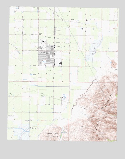
Arvin, CA USGS Topographic Map
Click on map above to begin viewing in our Map Viewer.

This topographic map contains these locations and features:
Feature Name Type Latitude Longitude GNIS ID View Map
Amargo SpringsSpringN35.1369°W118.8240°238577View Map
ArvinPopulated PlaceN35.2091°W118.8284°1652666View Map
Arvin Branch Kern County LibraryBuildingN35.2097°W118.8290°1839374View Map
Arvin City HallBuildingN35.2105°W118.8329°1839375View Map
Arvin High SchoolSchoolN35.2175°W118.8362°1839376View Map
Arvin Little League FieldParkN35.2158°W118.8270°1839377View Map
Arvin Mobile Home EstatesPopulated PlaceN35.2133°W118.8254°1839378View Map
Arvin Post OfficePost OfficeN35.2099°W118.8308°1839379View Map
Arvin Wesleyan ChurchChurchN35.1983°W118.8279°1839380View Map
Assembly of God Church of ArvinChurchN35.2080°W118.8312°1839381View Map
Bear Mountain Elementary SchoolSchoolN35.2019°W118.8393°1839382View Map
Bright Hope Baptist ChurchChurchN35.2089°W118.8390°1839383View Map
Calvary Church of God in ChristChurchN35.2122°W118.8259°1839385View Map
Church of the NazareneChurchN35.2133°W118.8309°1839387View Map
City of ArvinCivilN35.1944°W118.8306°2409738View Map
Comanche CreekStreamN35.1383°W118.8132°240825View Map
Comanche PointCapeN35.1322°W118.8223°240827View Map
Comanche SpringSpringN35.1324°W118.8137°240828View Map
Di Giorgio County ParkParkN35.2036°W118.8320°241479View Map
DiGiorgio Elementary SchoolSchoolN35.2380°W118.7873°241480View Map
Edmundson AcresPopulated PlaceN35.2289°W118.8232°1660590View Map
Edmundson Acres Census Designated PlaceCensusN35.2273°W118.8233°2629761View Map
Gospel Tabernacle of ArvinChurchN35.2089°W118.8362°1839389View Map
Haven Drive Middle SchoolSchoolN35.2050°W118.8273°243281View Map
J and J Crop Dusters Incorporated Airport (historical)AirportN35.1797°W118.8559°1653230View Map
Kern County BuildingBuildingN35.2102°W118.8290°1839390View Map
Kern County Fire Department Station 54 ArvinBuildingN35.2109°W118.8336°2665352View Map
Kovacevich ParkParkN35.2139°W118.8282°1839391View Map
Little Sycamore CanyonValleyN35.1666°W118.7907°244957View Map
Martina SpringSpringN35.1327°W118.7692°245569View Map
Mitchells CornerPopulated PlaceN35.2236°W118.8423°246045View Map
Pentecostal Church of ArvinChurchN35.2058°W118.8373°1839393View Map
Primera Iglesia BautistaChurchN35.2077°W118.8323°1839394View Map
Rock Pile School (historical)SchoolN35.2389°W118.7890°1662056View Map
Saint Thomas Catholic ChurchChurchN35.2094°W118.8276°1839395View Map
Sierra Vista Elementary SchoolSchoolN35.2025°W118.8262°249455View Map
Smothermon ParkParkN35.1989°W118.8357°1839396View Map
Sycamore CanyonValleyN35.2002°W118.7598°250200View Map
Vaccaro (historical)Populated PlaceN35.1944°W118.8154°1662069View Map
Veterans BuildingBuildingN35.2102°W118.8295°1839399View Map
Warm SpringSpringN35.1475°W118.7834°251176View Map

Note: Coordinates in the location and feature list above are referenced to NAD83 datum.


Copyright (C) 2008-2024 Ryan Niemi / Sunset Dynamics ... All Rights Reserved