TopoQuest Logo
Do you find TopoQuest useful?
Help keep TopoQuest running and adding new maps/features by donating!
Bitcoin:  19c7KJd3qBynnjoSw5npx9KScwjBe4ifkT
Litecoin:  LXs6TkuXGGXo1vDsWCkWVdjQX94eUKd6ui
Home View Maps Find Maps Find Places Resources & Links


Forreston, Texas Topographic Map

USGS Map Title: Forreston, TX
USGS Map MRC: 32096C7
DRG (GeoTIFF) Download: o32096c7.tif


Neighboring USGS Topographic Map Quads:


  Midlothian, TX  
32096D8
 

  Waxahachie, TX  
32096D7
 

  Palmer, TX  
32096D6
 

  Boz, TX  
32096C8
 

  Forreston, TX  
32096C7
 

  Ennis West, TX  
32096C6
 

  Italy, TX  
32096B8
 

  Avalon, TX  
32096B7
 

  Cryer Creek, TX  
32096B6


Map MRC Location:

N33°
W97°
N33°
W96°
H8 H7 H6 H5 H4 H3 H2 H1
G8 G7 G6 G5 G4 G3 G2 G1
F8 F7 F6 F5 F4 F3 F2 F1
E8 E7 E6 E5 E4 E3 E2 E1
D8 D7 D6 D5 D4 D3 D2 D1
C8 C7 C6 C5 C4 C3 C2 C1
B8 B7 B6 B5 B4 B3 B2 B1
A8 A7 A6 A5 A4 A3 A2 A1
N32°
W97°
N32°
W96°

Forreston, TX USGS 1:24K Topographic Map Preview:
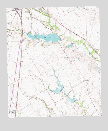
Forreston, TX USGS Topographic Map
Click on map above to begin viewing in our Map Viewer.

This topographic map contains these locations and features:
Feature Name Type Latitude Longitude GNIS ID View Map
Dunaway Elementary SchoolSchoolN32.3688°W96.8547°2004972View Map
Ellis CountyCivilN32.3484°W96.7945°1383856View Map
ForrestonPopulated PlaceN32.2563°W96.8653°1336043View Map
Forreston Post OfficePost OfficeN32.2577°W96.8662°2731399View Map
Forreston Volunteer Fire DepartmentBuildingN32.2559°W96.8651°2551770View Map
Garden Valley CemeteryCemeteryN32.2646°W96.8261°1336593View Map
George P Shanks AirportAirportN32.2976°W96.8725°1387717View Map
Haven FieldAirportN32.3271°W96.8402°2675954View Map
HowardPopulated PlaceN32.2907°W96.7711°1378470View Map
Lake WaxahachieReservoirN32.3408°W96.8234°1349562View Map
NashPopulated PlaceN32.2657°W96.8128°1378727View Map
NelsonPopulated PlaceN32.3138°W96.8569°1378732View Map
NenaPopulated PlaceN32.3271°W96.8558°1378735View Map
New Birth Community Bible ChurchChurchN32.3740°W96.8575°2018985View Map
Reagor SpringsPopulated PlaceN32.3288°W96.7608°1378938View Map
Soil Conservation Service Site 111 and 112 DamDamN32.2801°W96.8036°1856717View Map
Soil Conservation Service Site 111 and 112 ReservoirReservoirN32.2801°W96.8036°1856718View Map
Soil Conservation Service Site 113 DamDamN32.2668°W96.7853°1856711View Map
Soil Conservation Service Site 113 ReservoirReservoirN32.2668°W96.7853°1856712View Map
Soil Conservation Service Site 23 DamDamN32.3335°W96.7869°1856713View Map
Soil Conservation Service Site 23 ReservoirReservoirN32.3335°W96.7869°1856714View Map
Soil Conservation Service Site 24 DamDamN32.3201°W96.7736°1863122View Map
Soil Conservation Service Site 24 ReservoirReservoirN32.3201°W96.7736°1863123View Map
South Prong Baptist ChurchChurchN32.3738°W96.8575°2018953View Map
South Prong CreekStreamN32.3424°W96.8036°1376225View Map
South Prong DamDamN32.3418°W96.8053°1856715View Map
Spring ParkParkN32.3449°W96.8381°2029321View Map
Waxahachie DivisionCivilN32.3499°W96.8098°1939300View Map

Note: Coordinates in the location and feature list above are referenced to NAD83 datum.


Copyright (C) 2008-2024 Ryan Niemi / Sunset Dynamics ... All Rights Reserved