TopoQuest Logo
Do you find TopoQuest useful?
Help keep TopoQuest running and adding new maps/features by donating!
Bitcoin:  19c7KJd3qBynnjoSw5npx9KScwjBe4ifkT
Litecoin:  LXs6TkuXGGXo1vDsWCkWVdjQX94eUKd6ui
Home View Maps Find Maps Find Places Resources & Links


Forada, Minnesota Topographic Map

USGS Map Title: Forada, MN
USGS Map MRC: 45095G3
DRG (GeoTIFF) Download: o45095g3.tif


Neighboring USGS Topographic Map Quads:


  Alexandria West, MN  
45095H4
 

  Alexandria East, MN  
45095H3
 

  Lake Osakis West, MN  
45095H2
 

  Lake Mary, MN  
45095G4
 

  Forada, MN  
45095G3
 

  Osakis, MN  
45095G2
 

  Glenwood, MN  
45095F4
 

  Villard, MN  
45095F3
 

  Westport, MN  
45095F2


Map MRC Location:

N46°
W96°
N46°
W95°
H8 H7 H6 H5 H4 H3 H2 H1
G8 G7 G6 G5 G4 G3 G2 G1
F8 F7 F6 F5 F4 F3 F2 F1
E8 E7 E6 E5 E4 E3 E2 E1
D8 D7 D6 D5 D4 D3 D2 D1
C8 C7 C6 C5 C4 C3 C2 C1
B8 B7 B6 B5 B4 B3 B2 B1
A8 A7 A6 A5 A4 A3 A2 A1
N45°
W96°
N45°
W95°

Forada, MN USGS 1:24K Topographic Map Preview:
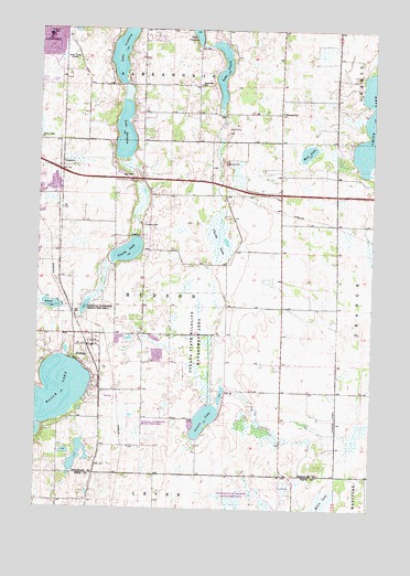
Forada, MN USGS Topographic Map
Click on map above to begin viewing in our Map Viewer.

This topographic map contains these locations and features:
Feature Name Type Latitude Longitude GNIS ID View Map
Aggies Landing Airport (historical)AirportN45.7733°W95.2631°660033View Map
Burgen Lake West Bound Rest AreaLocaleN45.8372°W95.3444°2069840View Map
Childs LakeSwampN45.8212°W95.3080°641156View Map
City of ForadaCivilN45.7887°W95.3573°2394784View Map
ForadaLocaleN45.7922°W95.3553°2069747View Map
ForadaPopulated PlaceN45.7922°W95.3556°643791View Map
Forada Fire and RescueBuildingN45.7920°W95.3540°2666215View Map
Forada Post Office (historical)Post OfficeN45.7922°W95.3553°2069748View Map
Hazel Hill SchoolSchoolN45.8605°W95.3159°644802View Map
House of Prayer Christian CenterChurchN45.8650°W95.3500°2069775View Map
Hudson CemeteryCemeteryN45.8238°W95.3361°645274View Map
KXRA-AM (Alexandria)TowerN45.8750°W95.3586°662890View Map
KXRA-FM (Alexandria)TowerN45.8750°W95.3586°663004View Map
Lake BurganLakeN45.8479°W95.3436°640653View Map
Lake JessieLakeN45.8646°W95.3073°645638View Map
Lovers LakeLakeN45.7732°W95.3125°647238View Map
Maple LakeLakeN45.7783°W95.3711°647489View Map
Maple Lake Inlet DamDamN45.8000°W95.3720°1777049View Map
Mud LakeLakeN45.8433°W95.2750°648264View Map
Sunnyside SchoolSchoolN45.8536°W95.2850°652833View Map
Technical SchoolSchoolN45.8730°W95.3720°653062View Map
Township of HudsonCivilN45.8019°W95.3245°664527View Map
Union LakeLakeN45.8171°W95.3418°653509View Map

Note: Coordinates in the location and feature list above are referenced to NAD83 datum.


Copyright (C) 2008-2024 Ryan Niemi / Sunset Dynamics ... All Rights Reserved