TopoQuest Logo
Do you find TopoQuest useful?
Help keep TopoQuest running and adding new maps/features by donating!
Bitcoin:  19c7KJd3qBynnjoSw5npx9KScwjBe4ifkT
Litecoin:  LXs6TkuXGGXo1vDsWCkWVdjQX94eUKd6ui
Home View Maps Find Maps Find Places Resources & Links


Flowella, Texas Topographic Map

USGS Map Title: Flowella, TX
USGS Map MRC: 27098B1
DRG (GeoTIFF) Download: o27098b1.tif


Neighboring USGS Topographic Map Quads:


  Premont West, TX  
27098C2
 

  Premont East, TX  
27098C1
 

  Paisano Lake, TX  
27097C8
 

  Falfurrias, TX  
27098B2
 

  Flowella, TX  
27098B1
 

  La Paloma Ranch, TX  
27097B8
 

  Cage Ranch, TX  
27098A2
 

  Falfurrias SE, TX  
27098A1
 

  Sarita SW, TX  
27097A8


Map MRC Location:

N28°
W99°
N28°
W98°
H8 H7 H6 H5 H4 H3 H2 H1
G8 G7 G6 G5 G4 G3 G2 G1
F8 F7 F6 F5 F4 F3 F2 F1
E8 E7 E6 E5 E4 E3 E2 E1
D8 D7 D6 D5 D4 D3 D2 D1
C8 C7 C6 C5 C4 C3 C2 C1
B8 B7 B6 B5 B4 B3 B2 B1
A8 A7 A6 A5 A4 A3 A2 A1
N27°
W99°
N27°
W98°

Flowella, TX USGS 1:24K Topographic Map Preview:
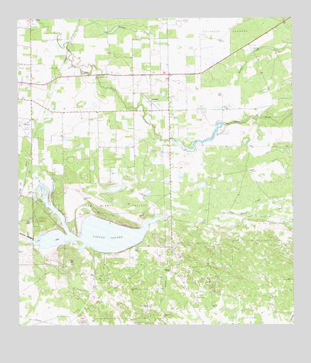
Flowella, TX USGS Topographic Map
Click on map above to begin viewing in our Map Viewer.

This topographic map contains these locations and features:
Feature Name Type Latitude Longitude GNIS ID View Map
Airport Road AdditionPopulated PlaceN27.2200°W98.0994°1852682View Map
Airport Road Addition Census Designated PlaceCensusN27.2190°W98.0981°2407702View Map
Airport Road Addition ColoniaPopulated PlaceN27.2142°W98.1122°2010303View Map
Arroyo BaluarteStreamN27.1587°W98.1161°1381020View Map
Betty Lou WindmillLocaleN27.2414°W98.0333°1330542View Map
Brooks County AirportAirportN27.2068°W98.1212°1386626View Map
Chamberlain Oil FieldOilfieldN27.2125°W98.0417°1332628View Map
Cuchilla PastureFlatN27.2484°W98.0303°1333781View Map
FlowellaPopulated PlaceN27.2164°W98.0644°1335980View Map
Flowella Census Designated PlaceCensusN27.2200°W98.0645°2408220View Map
Flowella Oil FieldOilfieldN27.2428°W98.0408°1335981View Map
Gardner RanchLocaleN27.1331°W98.0658°1336401View Map
Gyp HillSummitN27.1512°W98.1022°1337153View Map
Gyp Hill Oil FieldOilfieldN27.1448°W98.0861°1337154View Map
Indian RanchLocaleN27.1675°W98.1197°1338451View Map
Laguna SaladaLakeN27.1631°W98.0909°1339470View Map
Loma Blanca PastureFlatN27.1742°W98.0806°1340352View Map
Mariposa Oil FieldOilfieldN27.1467°W98.0436°1340962View Map
Mariposa RanchLocaleN27.1478°W98.0561°1340963View Map
New Pens WellWellN27.1675°W98.0561°1342500View Map
Old Pens WellWellN27.1781°W98.0678°1343193View Map
Pedro Garza Zamora CemeteryCemeteryN27.2264°W98.0900°1343796View Map
Perez CemeteryCemeteryN27.1528°W98.0739°1343848View Map
Perez RanchLocaleN27.1564°W98.0725°1343852View Map
Pita PastureFlatN27.1278°W98.0250°1344139View Map
Rush Addition ColoniaPopulated PlaceN27.2264°W98.1233°2010307View Map
Salt WellWellN27.1770°W98.0944°1346248View Map
Texas WellWellN27.1700°W98.0694°1348424View Map
West DamDamN27.2070°W98.0319°1857276View Map
West LakeReservoirN27.2047°W98.0350°1857277View Map

Note: Coordinates in the location and feature list above are referenced to NAD83 datum.


Copyright (C) 2008-2024 Ryan Niemi / Sunset Dynamics ... All Rights Reserved