TopoQuest Logo
Do you find TopoQuest useful?
Help keep TopoQuest running and adding new maps/features by donating!
Bitcoin:  19c7KJd3qBynnjoSw5npx9KScwjBe4ifkT
Litecoin:  LXs6TkuXGGXo1vDsWCkWVdjQX94eUKd6ui
Home View Maps Find Maps Find Places Resources & Links


Fivay Junction, Florida Topographic Map

USGS Map Title: Fivay Junction, FL
USGS Map MRC: 28082C5
DRG (GeoTIFF) Download: o28082c5.tif


Neighboring USGS Topographic Map Quads:


  Aripeka, FL  
28082D6
 

  Port Richey NE, FL  
28082D5
 

  Masaryktown, FL  
28082D4
 

  Port Richey, FL  
28082C6
 

  Fivay Junction, FL  
28082C5
 

  Ehren, FL  
28082C4
 

  Elfers, FL  
28082B6
 

  Odessa, FL  
28082B5
 

  Lutz, FL  
28082B4


Map MRC Location:

N29°
W83°
N29°
W82°
H8 H7 H6 H5 H4 H3 H2 H1
G8 G7 G6 G5 G4 G3 G2 G1
F8 F7 F6 F5 F4 F3 F2 F1
E8 E7 E6 E5 E4 E3 E2 E1
D8 D7 D6 D5 D4 D3 D2 D1
C8 C7 C6 C5 C4 C3 C2 C1
B8 B7 B6 B5 B4 B3 B2 B1
A8 A7 A6 A5 A4 A3 A2 A1
N28°
W83°
N28°
W82°

Fivay Junction, FL USGS 1:24K Topographic Map Preview:
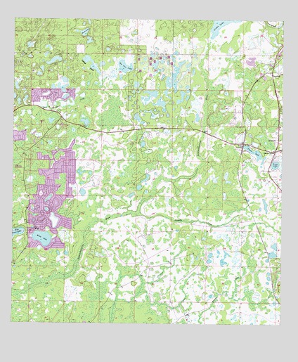
Fivay Junction, FL USGS Topographic Map
Click on map above to begin viewing in our Map Viewer.

This topographic map contains these locations and features:
Feature Name Type Latitude Longitude GNIS ID View Map
Bee Tree PondLakeN28.3561°W82.5726°278391View Map
Bethel ChurchChurchN28.3258°W82.5032°278534View Map
Buckhorn CreekSwampN28.3411°W82.5976°279604View Map
Cabbage SloughGutN28.3558°W82.5904°279802View Map
Cabbage Slough PondLakeN28.3557°W82.5886°298011View Map
Faith United Methodist ChurchChurchN28.3376°W82.6102°2481076View Map
Fivay CemeteryCemeteryN28.3311°W82.5187°282520View Map
Fivay JunctionPopulated PlaceN28.3239°W82.5184°294768View Map
Fivemile CreekStreamN28.2953°W82.5718°282527View Map
Florida Highway Patrol StationBuildingN28.3301°W82.5494°2333744View Map
Green LakeLakeN28.3162°W82.5030°283387View Map
GreenfieldPopulated PlaceN28.3536°W82.5048°295321View Map
Meadow Oaks Census Designated PlaceCensusN28.3465°W82.6025°2583362View Map
Moon LakeLakeN28.2851°W82.6109°287088View Map
Moon Lake Census Designated PlaceCensusN28.3002°W82.6049°2583365View Map
Moon Lake Elementary SchoolSchoolN28.3328°W82.6119°298763View Map
Pierce LakeLakeN28.3211°W82.5130°288795View Map
Quail Ridge Census Designated PlaceCensusN28.3453°W82.5532°2583377View Map
River Ridge Census Designated PlaceCensusN28.2673°W82.6248°2583379View Map
River Ridge Middle SchoolSchoolN28.2676°W82.6209°2485593View Map
Rock LakeLakeN28.3699°W82.5921°289835View Map
West Moon LakeLakeN28.2875°W82.6234°293096View Map

Note: Coordinates in the location and feature list above are referenced to NAD83 datum.


Copyright (C) 2008-2024 Ryan Niemi / Sunset Dynamics ... All Rights Reserved