TopoQuest Logo
Do you find TopoQuest useful?
Help keep TopoQuest running and adding new maps/features by donating!
Bitcoin:  19c7KJd3qBynnjoSw5npx9KScwjBe4ifkT
Litecoin:  LXs6TkuXGGXo1vDsWCkWVdjQX94eUKd6ui
Home View Maps Find Maps Find Places Resources & Links


Fayetteville, Texas Topographic Map

USGS Map Title: Fayetteville, TX
USGS Map MRC: 29096H6
DRG (GeoTIFF) Download: o29096h6.tif


Neighboring USGS Topographic Map Quads:


  Nechanitz, TX  
30096A7
 

  Round Top, TX  
30096A6
 

  Greenvine, TX  
30096A5
 

  La Grange East, TX  
29096H7
 

  Fayetteville, TX  
29096H6
 

  Industry, TX  
29096H5
 

  Ammannsville, TX  
29096G7
 

  Ellinger, TX  
29096G6
 

  Frelsburg, TX  
29096G5


Map MRC Location:

N30°
W97°
N30°
W96°
H8 H7 H6 H5 H4 H3 H2 H1
G8 G7 G6 G5 G4 G3 G2 G1
F8 F7 F6 F5 F4 F3 F2 F1
E8 E7 E6 E5 E4 E3 E2 E1
D8 D7 D6 D5 D4 D3 D2 D1
C8 C7 C6 C5 C4 C3 C2 C1
B8 B7 B6 B5 B4 B3 B2 B1
A8 A7 A6 A5 A4 A3 A2 A1
N29°
W97°
N29°
W96°

Fayetteville, TX USGS 1:24K Topographic Map Preview:
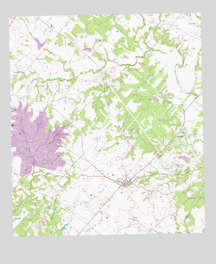
Fayetteville, TX USGS Topographic Map
Click on map above to begin viewing in our Map Viewer.

This topographic map contains these locations and features:
Feature Name Type Latitude Longitude GNIS ID View Map
Allen CreekStreamN29.9155°W96.6303°1350996View Map
Big Spring Hill ChurchChurchN29.9755°W96.7325°1352147View Map
Camp CreekStreamN29.9711°W96.6708°1353615View Map
Cedar Creek DamDamN29.9152°W96.7369°1862867View Map
City of FayettevilleCivilN29.9063°W96.6759°2410492View Map
Clear CreekStreamN29.9797°W96.6564°1373130View Map
Eilers CemeteryCemeteryN29.9008°W96.7033°1356856View Map
Fayette County Emergency Medical ServicesBuildingN29.9030°W96.6757°2655984View Map
FayettevillePopulated PlaceN29.9058°W96.6728°1357269View Map
Fayetteville City HallBuildingN29.9031°W96.6758°2753680View Map
Fayetteville DivisionCivilN29.9231°W96.6789°1938738View Map
Fayetteville Elementary SchoolSchoolN29.9055°W96.6814°2005808View Map
Fayetteville High SchoolSchoolN29.9055°W96.6814°2005809View Map
Fayetteville Post OfficePost OfficeN29.9056°W96.6736°2731907View Map
Fayetteville Volunteer Fire DepartmentBuildingN29.9030°W96.6757°2552288View Map
Groce BranchStreamN29.9208°W96.7355°1358460View Map
Halimecek CemeteryCemeteryN29.9599°W96.6880°1358660View Map
Haw CreekStreamN29.9852°W96.6614°1374020View Map
Jones CreekStreamN29.9538°W96.6303°1374318View Map
Lake FayetteReservoirN29.9301°W96.7343°1377461View Map
Lost Prairie ChurchChurchN29.8833°W96.6708°1361840View Map
Mesquite North Branch LibraryBuildingN29.9180°W96.6389°2014819View Map
Mount Pilgrim ChurchChurchN29.9191°W96.6553°1363301View Map
Nicholson Memorial Library SystemBuildingN29.9438°W96.6375°2014832View Map
North Garland Branch LibraryBuildingN29.9519°W96.6503°2014835View Map
Pleasant Grove Branch LibraryBuildingN29.9991°W96.6830°2014788View Map
Rek HillPopulated PlaceN29.9324°W96.6403°1380432View Map
RoznovPopulated PlaceN29.9844°W96.7083°1380468View Map
Soil Conservation Service Site 23 DamDamN29.9819°W96.7286°1857994View Map
Soil Conservation Service Site 23 ReservoirReservoirN29.9819°W96.7286°1857995View Map
Soil Conservation Service Site 24 DamDamN29.9802°W96.6969°1857996View Map
Soil Conservation Service Site 24 ReservoirReservoirN29.9806°W96.6985°1857997View Map
Soil Conservation Service Site 25 DamDamN29.9519°W96.6536°1858002View Map
Soil Conservation Service Site 25 ReservoirReservoirN29.9515°W96.6555°1858003View Map
Soil Conservation Service Site 29 DamDamN29.9252°W96.6703°1858000View Map
Soil Conservation Service Site 29 ReservoirReservoirN29.9244°W96.6714°1858001View Map
Soil Conservation Service Site 30 DamDamN29.9169°W96.6336°1857998View Map
Soil Conservation Service Site 30 ReservoirReservoirN29.9175°W96.6371°1857999View Map
Spencer Pool CreekStreamN29.9644°W96.7080°1376246View Map
Sweet Home ChurchChurchN29.9299°W96.6422°1369464View Map
TambergPopulated PlaceN29.9094°W96.7194°1380641View Map
Texas No Name Number 53 DamDamN29.8786°W96.7186°1865405View Map
Zapp BuildingBuildingN29.9041°W96.6769°2032354View Map

Note: Coordinates in the location and feature list above are referenced to NAD83 datum.


Copyright (C) 2008-2024 Ryan Niemi / Sunset Dynamics ... All Rights Reserved