TopoQuest Logo
Do you find TopoQuest useful?
Help keep TopoQuest running and adding new maps/features by donating!
Bitcoin:  19c7KJd3qBynnjoSw5npx9KScwjBe4ifkT
Litecoin:  LXs6TkuXGGXo1vDsWCkWVdjQX94eUKd6ui
Home View Maps Find Maps Find Places Resources & Links


Arnaudville, Louisiana Topographic Map

USGS Map Title: Arnaudville, LA
USGS Map MRC: 30091D8
DRG (GeoTIFF) Download: o30091d8.tif


Neighboring USGS Topographic Map Quads:


  Opelousas, LA  
30092E1
 

  Port Barre, LA  
30091E8
 

  Krotz Springs, LA  
30091E7
 

  Sunset, LA  
30092D1
 

  Arnaudville, LA  
30091D8
 

  Portage, LA  
30091D7
 

  Carencro, LA  
30092C1
 

  Breaux Bridge, LA  
30091C8
 

  Cecilia, LA  
30091C7


Map MRC Location:

N31°
W92°
N31°
W91°
H8 H7 H6 H5 H4 H3 H2 H1
G8 G7 G6 G5 G4 G3 G2 G1
F8 F7 F6 F5 F4 F3 F2 F1
E8 E7 E6 E5 E4 E3 E2 E1
D8 D7 D6 D5 D4 D3 D2 D1
C8 C7 C6 C5 C4 C3 C2 C1
B8 B7 B6 B5 B4 B3 B2 B1
A8 A7 A6 A5 A4 A3 A2 A1
N30°
W92°
N30°
W91°

Arnaudville, LA USGS 1:24K Topographic Map Preview:
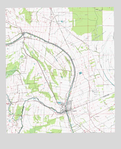
Arnaudville, LA USGS Topographic Map
Click on map above to begin viewing in our Map Viewer.

This topographic map contains these locations and features:
Feature Name Type Latitude Longitude GNIS ID View Map
ArnaudvillePopulated PlaceN30.3977°W91.9315°559793View Map
Arnaudville Elementary SchoolSchoolN30.3981°W91.9351°552564View Map
Arnaudville High SchoolSchoolN30.3983°W91.9351°552565View Map
Arnaudville Oil and Gas FieldOilfieldN30.4163°W91.9637°552566View Map
Arnaudville Police DepartmentBuildingN30.3964°W91.9355°2333985View Map
Arnaudville Volunteer Fire DepartmentBuildingN30.3968°W91.9356°2332700View Map
Arnaudville Wastewater Treatment PlantLocaleN30.4054°W91.9391°2603392View Map
Bayou BourbeuxStreamN30.3921°W91.9826°559884View Map
Bayou FusilierStreamN30.3969°W91.9310°559958View Map
Bayou GerimondStreamN30.4974°W91.8965°559966View Map
Coteau RodairePopulated PlaceN30.3913°W91.8993°560476View Map
Couvillion AirportAirportN30.3976°W91.9776°2676759View Map
DarbyPopulated PlaceN30.3844°W91.9201°560582View Map
FrozardPopulated PlaceN30.4060°W91.9935°560806View Map
Huron Head Start Center SchoolSchoolN30.3764°W91.8912°2600225View Map
J Michael Morrow Memorial Nursing HomeBuildingN30.4134°W91.9337°2601045View Map
Kipper School (historical)SchoolN30.4071°W91.9646°551531View Map
LeonvillePopulated PlaceN30.4705°W91.9785°1627472View Map
Leonville Elementary SchoolSchoolN30.4752°W91.9796°1629696View Map
Leonville Head Start Center SchoolSchoolN30.4681°W91.9842°2600235View Map
Leonville High SchoolSchoolN30.4755°W91.9801°552623View Map
Leonville Police DepartmentBuildingN30.4711°W91.9795°2334136View Map
Leonville Volunteer Fire DepartmentBuildingN30.4759°W91.9780°2332457View Map
Leonville Wastewater Treatment PlantLocaleN30.4704°W91.9649°2603462View Map
Louisiana Noname 48 DamDamN30.4035°W91.9368°1628796View Map
Parish Governing Authority District 7CivilN30.4455°W91.9333°1930207View Map
PecanierePopulated PlaceN30.4844°W91.9382°1627893View Map
Pointe ClairePopulated PlaceN30.4380°W91.9582°1627965View Map
Prairie Des FemmesLocaleN30.4344°W91.9840°1627996View Map
Ring Zion CemeteryCemeteryN30.3813°W91.9151°1628058View Map
RobinPopulated PlaceN30.4480°W91.9240°552656View Map
Robin BridgeBridgeN30.4480°W91.9240°1628065View Map
Sacred Heart ChapelChurchN30.4096°W91.9982°1628089View Map
Saint Catherine's Catholic ChurchChurchN30.4647°W91.9912°2602615View Map
Saint Francis Regis ChurchChurchN30.3995°W91.9322°2602624View Map
Saint Landry Parish Fire District 5 Prairie Volunteer Fire DepartmentBuildingN30.4052°W91.9967°2332317View Map
Saint Leo the Great ChurchChurchN30.4742°W91.9823°2602684View Map
Saint Luke General HospitalHospitalN30.4024°W91.9354°552674View Map
Saint Luke General Hospital HeliportAirportN30.4019°W91.9351°1632607View Map
Saint Martin Parish Library Arnaudville BramchBuildingN30.3947°W91.9327°2603129View Map
Saint Martin Parish Police JuryBuildingN30.3964°W91.9354°2334129View Map
Tim Bullard Memorial AirportAirportN30.4160°W91.9766°2676803View Map
Town of ArnaudvilleCivilN30.4022°W91.9320°2405170View Map
Town of LeonvilleCivilN30.4661°W91.9811°2406006View Map
Ward ThreeCivilN30.4446°W91.9582°1628606View Map

Note: Coordinates in the location and feature list above are referenced to NAD83 datum.


Copyright (C) 2008-2024 Ryan Niemi / Sunset Dynamics ... All Rights Reserved