TopoQuest Logo
Do you find TopoQuest useful?
Help keep TopoQuest running and adding new maps/features by donating!
Bitcoin:  19c7KJd3qBynnjoSw5npx9KScwjBe4ifkT
Litecoin:  LXs6TkuXGGXo1vDsWCkWVdjQX94eUKd6ui
Home View Maps Find Maps Find Places Resources & Links


Fairfield Bay, Arkansas Topographic Map

USGS Map Title: Fairfield Bay, AR
USGS Map MRC: 35092E3
DRG (GeoTIFF) Download: o35092e3.tif


Neighboring USGS Topographic Map Quads:


  Old Lexington, AR  
35092F4
 

  Shirley, AR  
35092F3
 

  Parma, AR  
35092F2
 

  Clinton, AR  
35092E4
 

  Fairfield Bay, AR  
35092E3
 

  Greers Ferry, AR  
35092E2
 

  Bee Branch, AR  
35092D4
 

  Morganton, AR  
35092D3
 

  Quitman, AR  
35092D2


Map MRC Location:

N36°
W93°
N36°
W92°
H8 H7 H6 H5 H4 H3 H2 H1
G8 G7 G6 G5 G4 G3 G2 G1
F8 F7 F6 F5 F4 F3 F2 F1
E8 E7 E6 E5 E4 E3 E2 E1
D8 D7 D6 D5 D4 D3 D2 D1
C8 C7 C6 C5 C4 C3 C2 C1
B8 B7 B6 B5 B4 B3 B2 B1
A8 A7 A6 A5 A4 A3 A2 A1
N35°
W93°
N35°
W92°

Fairfield Bay, AR USGS 1:24K Topographic Map Preview:
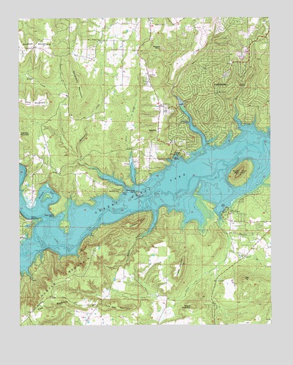
Fairfield Bay, AR USGS Topographic Map
Click on map above to begin viewing in our Map Viewer.

This topographic map contains these locations and features:
Feature Name Type Latitude Longitude GNIS ID View Map
Bailey HollowValleyN35.5473°W92.3079°46018View Map
Banner MountainSummitN35.6123°W92.3613°57325View Map
Bloomington (historical)Populated PlaceN35.5301°W92.3635°68647View Map
Boat Ridge IslandIslandN35.5542°W92.3171°46784View Map
Bradford CemeteryCemeteryN35.6220°W92.3021°46886View Map
Burnt Ridge Fire Station Banner MountainBuildingN35.6197°W92.3560°2116207View Map
Choctaw CreekStreamN35.5323°W92.3615°47764View Map
Choctaw PinesPopulated PlaceN35.5201°W92.3446°68652View Map
City of Fairfield BayCivilN35.6051°W92.2660°2403589View Map
Clinton WaterworksLocaleN35.5431°W92.3688°82006View Map
Dave CreekStreamN35.5781°W92.2613°48364View Map
Dougherty MountainSummitN35.5942°W92.3457°48581View Map
EglantinePopulated PlaceN35.5795°W92.3063°57001View Map
Eglantine CemeteryCemeteryN35.6017°W92.3121°48825View Map
Fairfield BayPopulated PlaceN35.5942°W92.2779°57738View Map
Fairfield Bay MarinaLocaleN35.5681°W92.2982°68664View Map
Fairfield Bay Police DepartmentBuildingN35.6202°W92.2597°2118837View Map
Fairfield Bay Volunteer Fire Department Station 1BuildingN35.6202°W92.2597°2116419View Map
Fairfield Bay Volunteer Fire Department Station 2BuildingN35.5747°W92.2988°2116420View Map
Fairfield Bay Volunteer Rescue ServiceBuildingN35.6202°W92.2596°2119150View Map
Green CreekStreamN35.5570°W92.3177°49629View Map
Harpers CoveBayN35.5548°W92.3618°49883View Map
High TopSummitN35.5190°W92.2643°57922View Map
Hooten HollowValleyN35.5762°W92.2513°50292View Map
Hunter MountainSummitN35.5040°W92.3718°57961View Map
Lazy CreekStreamN35.5431°W92.2757°51017View Map
Lewallen MountainSummitN35.5240°W92.2949°51075View Map
Low Gap MountainSummitN35.5084°W92.3282°58093View Map
Lynn CreekStreamN35.5706°W92.2815°51527View Map
Moccasin BranchStreamN35.5356°W92.2715°52118View Map
PalisadesPopulated PlaceN35.5320°W92.3365°68683View Map
Peter Rock PointCapeN35.5456°W92.3577°53302View Map
Pine Grove ChurchChurchN35.6134°W92.3677°53429View Map
Pleasant Valley ChurchChurchN35.6159°W92.3343°53616View Map
South Fork Recreation AreaLocaleN35.5556°W92.3254°78409View Map
Standley ChurchChurchN35.5620°W92.3560°55152View Map
Stevens PointCapeN35.5415°W92.3160°55210View Map
Sugar Loaf MountainSummitN35.5612°W92.2663°55308View Map
Sugar Loaf Recreation AreaParkN35.5459°W92.2724°78481View Map
Thompson CreekStreamN35.5548°W92.3213°55541View Map
Township of DavisCivilN35.5049°W92.3060°69767View Map
Township of Indian RockCivilN35.6065°W92.2710°69771View Map
Township of Red RiverCivilN35.5655°W92.3209°69775View Map
Township of Sulphur Springs (historical)CivilN35.5084°W92.2710°68704View Map
United Methodist ChurchChurchN35.5945°W92.2777°55840View Map
Van Buren Recreation AreaParkN35.5701°W92.2971°78648View Map
Wild Goose BranchStreamN35.5229°W92.2502°56352View Map
Williams RocksPillarN35.6120°W92.3049°56404View Map
Wright MountainSummitN35.5076°W92.2888°58919View Map

Note: Coordinates in the location and feature list above are referenced to NAD83 datum.


Copyright (C) 2008-2024 Ryan Niemi / Sunset Dynamics ... All Rights Reserved