TopoQuest Logo
Do you find TopoQuest useful?
Help keep TopoQuest running and adding new maps/features by donating!
Bitcoin:  19c7KJd3qBynnjoSw5npx9KScwjBe4ifkT
Litecoin:  LXs6TkuXGGXo1vDsWCkWVdjQX94eUKd6ui
Home View Maps Find Maps Find Places Resources & Links


Arlington, Oklahoma Topographic Map

USGS Map Title: Arlington, OK
USGS Map MRC: 35096E6
DRG (GeoTIFF) Download: o35096e6.tif


Neighboring USGS Topographic Map Quads:


  Davenport, OK  
35096F7
 

  Stroud South, OK  
35096F6
 

  Ritts Junction, OK  
35096F5
 

  Sparks, OK  
35096E7
 

  Arlington, OK  
35096E6
 

  Paden, OK  
35096E5
 

  Shawnee NE, OK  
35096D7
 

  Prague, OK  
35096D6
 

  Prague NE, OK  
35096D5


Map MRC Location:

N36°
W97°
N36°
W96°
H8 H7 H6 H5 H4 H3 H2 H1
G8 G7 G6 G5 G4 G3 G2 G1
F8 F7 F6 F5 F4 F3 F2 F1
E8 E7 E6 E5 E4 E3 E2 E1
D8 D7 D6 D5 D4 D3 D2 D1
C8 C7 C6 C5 C4 C3 C2 C1
B8 B7 B6 B5 B4 B3 B2 B1
A8 A7 A6 A5 A4 A3 A2 A1
N35°
W97°
N35°
W96°

Arlington, OK USGS 1:24K Topographic Map Preview:
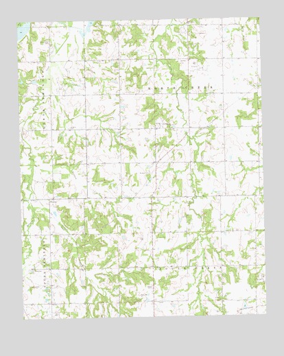
Arlington, OK USGS Topographic Map
Click on map above to begin viewing in our Map Viewer.

This topographic map contains these locations and features:
Feature Name Type Latitude Longitude GNIS ID View Map
ArlingtonPopulated PlaceN35.5790°W96.6797°1089694View Map
Arlington CemeteryCemeteryN35.5606°W96.6836°1089695View Map
Arlington Volunteer Fire DepartmentBuildingN35.5786°W96.6808°2657196View Map
Bartosh CreekStreamN35.5128°W96.7117°2740976View Map
Bethel Grove CemeteryCemeteryN35.6156°W96.7336°1090059View Map
Big Wewoka Creek Site 16 DamDamN35.5851°W96.6653°1757215View Map
Big Wewoka Creek Site 16 ReservoirReservoirN35.5851°W96.6653°1757216View Map
Deer Creek ChurchChurchN35.6231°W96.6620°1092020View Map
Guild/Pleasant Valley CemeteryCemeteryN35.5203°W96.7442°1099201View Map
Kellerby CemeteryCemeteryN35.5798°W96.7247°1094313View Map
Kyker CemeteryCemeteryN35.5058°W96.6808°2704480View Map
Prague DivisionCivilN35.5524°W96.7154°1937830View Map
Prague LakeReservoirN35.5246°W96.7209°1763670View Map
Robinson CreekStreamN35.6195°W96.7156°1097263View Map
Robinson Creek Site Number 2 DamDamN35.5551°W96.7136°1756359View Map
Robinson Creek Site Number 2 ReservoirReservoirN35.5551°W96.7136°1756360View Map
Sand CreekStreamN35.5526°W96.7453°1097746View Map
Township of North CreekCivilN35.5959°W96.6670°1824923View Map
Township of South CreekCivilN35.5195°W96.6670°1824928View Map
Warsham CreekStreamN35.5678°W96.7447°1099381View Map
WilzettaPopulated PlaceN35.5503°W96.7356°1100942View Map

Note: Coordinates in the location and feature list above are referenced to NAD83 datum.


Copyright (C) 2008-2024 Ryan Niemi / Sunset Dynamics ... All Rights Reserved