TopoQuest Logo
Do you find TopoQuest useful?
Help keep TopoQuest running and adding new maps/features by donating!
Bitcoin:  19c7KJd3qBynnjoSw5npx9KScwjBe4ifkT
Litecoin:  LXs6TkuXGGXo1vDsWCkWVdjQX94eUKd6ui
Home View Maps Find Maps Find Places Resources & Links


Effie, Louisiana Topographic Map

USGS Map Title: Effie, LA
USGS Map MRC: 31092B2
DRG (GeoTIFF) Download: o31092b2.tif


Neighboring USGS Topographic Map Quads:


  Libuse, LA  
31092C3
 

  Buckeye, LA  
31092C2
 

  Powell Point, LA  
31092C1
 

  Latanier, LA  
31092B3
 

  Effie, LA  
31092B2
 

  Marksville North, LA  
31092B1
 

  Cheneyville, LA  
31092A3
 

  Belle d'Eau, LA  
31092A2
 

  Marksville South, LA  
31092A1


Map MRC Location:

N32°
W93°
N32°
W92°
H8 H7 H6 H5 H4 H3 H2 H1
G8 G7 G6 G5 G4 G3 G2 G1
F8 F7 F6 F5 F4 F3 F2 F1
E8 E7 E6 E5 E4 E3 E2 E1
D8 D7 D6 D5 D4 D3 D2 D1
C8 C7 C6 C5 C4 C3 C2 C1
B8 B7 B6 B5 B4 B3 B2 B1
A8 A7 A6 A5 A4 A3 A2 A1
N31°
W93°
N31°
W92°

Effie, LA USGS 1:24K Topographic Map Preview:
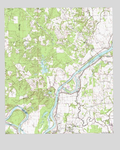
Effie, LA USGS Topographic Map
Click on map above to begin viewing in our Map Viewer.

This topographic map contains these locations and features:
Feature Name Type Latitude Longitude GNIS ID View Map
Big LakeLakeN31.1888°W92.1457°553646View Map
Bordelon LakeLakeN31.1658°W92.1983°556657View Map
Bringol LandingLocaleN31.1435°W92.1982°545491View Map
Cannon LakeLakeN31.1755°W92.1919°553888View Map
CassandraPopulated PlaceN31.1891°W92.1690°543061View Map
Cassandria LandingLocaleN31.1891°W92.1635°545497View Map
Center PointPopulated PlaceN31.2482°W92.2099°553936View Map
Center Point Post OfficePost OfficeN31.2486°W92.2089°1630196View Map
Champignol LakeLakeN31.1835°W92.1808°555989View Map
Cow CreekStreamN31.2077°W92.2087°541938View Map
Dads Lake (historical)LakeN31.1391°W92.2382°551830View Map
David Ferry (historical)CrossingN31.2021°W92.1412°545503View Map
EffiePopulated PlaceN31.2160°W92.1557°543167View Map
Effie Post OfficePost OfficeN31.2178°W92.1560°1630200View Map
Effie Volunteer Fire DepartmentBuildingN31.2158°W92.1546°2673143View Map
Egg BendPopulated PlaceN31.1338°W92.1901°554349View Map
Experiment Plantation (historical)LocaleN31.1988°W92.1376°545510View Map
Fifth WardPopulated PlaceN31.1302°W92.1729°543202View Map
Fifth Ward ChurchChurchN31.1277°W92.1765°541939View Map
Fifth Ward SchoolSchoolN31.1291°W92.1735°545511View Map
Fifth Ward Volunteer Fire DepartmentBuildingN31.1262°W92.1717°2672963View Map
Fifth Ward Volunteer Fire DepartmentBuildingN31.1273°W92.1731°2673038View Map
French CemeteryCemeteryN31.2466°W92.1829°535099View Map
George Guillott LandingLocaleN31.1369°W92.1946°545518View Map
Gin BayouStreamN31.1594°W92.1918°549601View Map
Gin LakeLakeN31.1441°W92.2044°554531View Map
Grime Lake (historical)LakeN31.1477°W92.2243°554625View Map
Grimes BluffCliffN31.1474°W92.2251°545519View Map
Grimes Bluff LandingLocaleN31.1427°W92.2232°545520View Map
Harrisons BranchStreamN31.1807°W92.2224°551213View Map
Hays CemeteryCemeteryN31.2146°W92.1840°535581View Map
Hays ChapelChurchN31.2146°W92.1835°541940View Map
Lafargue Elementary SchoolSchoolN31.2154°W92.1553°541941View Map
Luneau Chapel (historical)ChurchN31.2474°W92.1826°545534View Map
Marksville Middle SchoolSchoolN31.1289°W92.1735°545541View Map
Martinez LandingLocaleN31.1599°W92.1890°545546View Map
Midway LandingLocaleN31.2041°W92.1410°545548View Map
Moncla LandingLocaleN31.2007°W92.1404°545550View Map
Myrtle Grove LandingLocaleN31.2002°W92.1462°545551View Map
Oak Grove CemeteryCemeteryN31.2246°W92.1632°545559View Map
Oak Grove ChurchChurchN31.2246°W92.1646°537781View Map
Once More LandingLocaleN31.1299°W92.2351°551753View Map
Our Lady of Lourdes ChurchChurchN31.1307°W92.1771°541942View Map
Pierce CemeteryCemeteryN31.2152°W92.2398°538121View Map
Pillars CreekStreamN31.1866°W92.2071°538151View Map
Pine Grove ChurchChurchN31.1796°W92.2468°555654View Map
Pine Grove School (historical)SchoolN31.1952°W92.2340°551757View Map
Pinegrove (historical)Populated PlaceN31.1946°W92.2362°551758View Map
Rays Landing StripAirportN31.1341°W92.1762°545567View Map
Redmond BayouStreamN31.1719°W92.1976°555784View Map
ReynoldsPopulated PlaceN31.2169°W92.2279°543618View Map
Reynolds LakeLakeN31.1912°W92.2049°555793View Map
Riverside ChurchChurchN31.2102°W92.1315°538627View Map
RubyPopulated PlaceN31.1894°W92.2487°538760View Map
Ruby Post OfficePost OfficeN31.1891°W92.2490°1631701View Map
Ruby School (historical)SchoolN31.1944°W92.2382°551770View Map
Saint Catherine CemeteryCemeteryN31.1696°W92.1323°538814View Map
Saint Catherine ChurchChurchN31.1699°W92.1315°541943View Map
Saint Winfred ChurchChurchN31.2288°W92.1710°539083View Map
Star Light ChurchChurchN31.1760°W92.1371°556136View Map
Swoffords CreekStreamN31.2485°W92.2424°556193View Map
Upper Ashland LandingLocaleN31.1838°W92.1710°545584View Map
Wiggins BayouStreamN31.1646°W92.1915°556416View Map

Note: Coordinates in the location and feature list above are referenced to NAD83 datum.


Copyright (C) 2008-2024 Ryan Niemi / Sunset Dynamics ... All Rights Reserved