TopoQuest Logo
Do you find TopoQuest useful?
Help keep TopoQuest running and adding new maps/features by donating!
Bitcoin:  19c7KJd3qBynnjoSw5npx9KScwjBe4ifkT
Litecoin:  LXs6TkuXGGXo1vDsWCkWVdjQX94eUKd6ui
Home View Maps Find Maps Find Places Resources & Links


Dillard, Georgia Topographic Map

USGS Map Title: Dillard, GA
USGS Map MRC: 34083H4
DRG (GeoTIFF) Download: o34083h4.tif


Neighboring USGS Topographic Map Quads:


  Rainbow Springs, NC  
35083A5
 

  Prentiss, NC  
35083A4
 

  Scaly Mountain, NC  
35083A3
 

  Hightower Bald, GA  
34083H5
 

  Dillard, GA  
34083H4
 

  Rabun Bald, GA  
34083H3
 

  Lake Burton, GA  
34083G5
 

  Tiger, GA  
34083G4
 

  Rainy Mountain, GA  
34083G3


Map MRC Location:

N35°
W84°
N35°
W83°
H8 H7 H6 H5 H4 H3 H2 H1
G8 G7 G6 G5 G4 G3 G2 G1
F8 F7 F6 F5 F4 F3 F2 F1
E8 E7 E6 E5 E4 E3 E2 E1
D8 D7 D6 D5 D4 D3 D2 D1
C8 C7 C6 C5 C4 C3 C2 C1
B8 B7 B6 B5 B4 B3 B2 B1
A8 A7 A6 A5 A4 A3 A2 A1
N34°
W84°
N34°
W83°

Dillard, GA USGS 1:24K Topographic Map Preview:
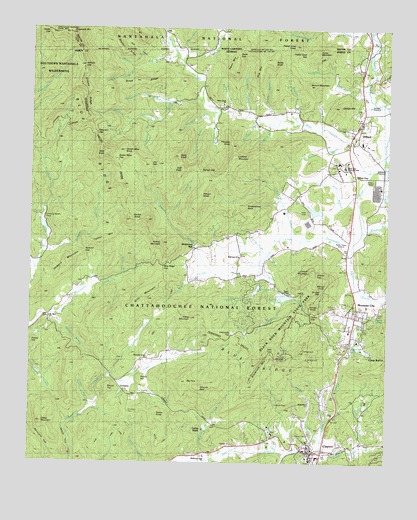
Dillard, GA USGS Topographic Map
Click on map above to begin viewing in our Map Viewer.

This topographic map contains these locations and features:
Feature Name Type Latitude Longitude GNIS ID View Map
Almond BaldLocaleN34.8965°W83.4402°326942View Map
Arnold BranchStreamN34.8898°W83.4791°326966View Map
Asa CoveValleyN34.9911°W83.4584°1008784View Map
Ashley CreekStreamN34.8759°W83.4368°326974View Map
Barkers CreekStreamN34.9904°W83.4477°327008View Map
Beavert BranchStreamN34.9734°W83.4065°327045View Map
Beavert MountainSummitN34.9840°W83.4038°331121View Map
Betty CreekStreamN34.9598°W83.3802°354694View Map
Betty Creek ChurchChurchN34.9784°W83.4335°354695View Map
Bettys Creek Recreation AreaParkN34.9834°W83.4415°351477View Map
Big FaceSummitN34.8984°W83.4446°327111View Map
Billy CreekStreamN34.9304°W83.4363°327135View Map
Billy MountainSummitN34.9220°W83.4585°331167View Map
Black Rock ChurchChurchN34.8926°W83.4024°330552View Map
Black Rock LakeLakeN34.9230°W83.4109°330554View Map
Black Rock Lake DamDamN34.9229°W83.4115°339168View Map
Black Rock Mountain State ParkParkN34.9095°W83.4152°327150View Map
Blackrock MountainSummitN34.9034°W83.4207°354758View Map
Blacks BranchStreamN34.9479°W83.3846°327152View Map
Blacks CreekStreamN34.9384°W83.3871°327153View Map
Blue Heights ChurchChurchN34.9104°W83.3890°354779View Map
Blue Ridge GapGapN34.9318°W83.4532°354783View Map
Boardpile BranchStreamN34.9762°W83.4385°327186View Map
Camp BarronLocaleN34.9065°W83.3802°327328View Map
Camp DixieLocaleN34.8851°W83.4388°327337View Map
Carson BranchStreamN34.9740°W83.4132°327367View Map
Carter GapGapN34.9993°W83.4940°1010069View Map
Cedar KnobSummitN34.9451°W83.4590°1730643View Map
City of ClaytonCivilN34.8774°W83.4019°2404066View Map
City of DillardCivilN34.9748°W83.3820°2404229View Map
ClaytonPopulated PlaceN34.8781°W83.4010°355183View Map
Clayton DivisionCivilN34.9293°W83.4882°1936182View Map
Clayton Elementary SchoolSchoolN34.8793°W83.4071°351467View Map
Clayton Police DepartmentBuildingN34.8826°W83.3992°2733782View Map
Coffee BranchStreamN34.8915°W83.4782°327479View Map
Coleman River Wildlife Management AreaParkN34.9668°W83.4899°327494View Map
Commissioner CreekStreamN34.9998°W83.3821°1010427View Map
Covered Bridge Plaza Shopping CenterLocaleN34.8787°W83.3963°351469View Map
Covered Bridge Shopping CenterLocaleN34.8770°W83.3985°351470View Map
Cox LakeReservoirN34.9088°W83.3851°327543View Map
Cox Lake DamDamN34.9095°W83.3863°339234View Map
Darling SpringSpringN34.9171°W83.3802°327595View Map
Darnell CreekStreamN34.9620°W83.3757°355445View Map
Darnell GapGapN34.9590°W83.4415°327597View Map
Devils BranchStreamN34.9176°W83.4915°327634View Map
Dickerson MillPopulated PlaceN34.9379°W83.4427°331548View Map
DillardPopulated PlaceN34.9701°W83.3871°327649View Map
Dillard Police DepartmentBuildingN34.9676°W83.3843°2733585View Map
Double BranchStreamN34.9359°W83.4185°1730644View Map
Double BranchStreamN34.9301°W83.4329°327671View Map
Double KnobSummitN34.9445°W83.4652°331579View Map
Drive RidgeRidgeN34.9848°W83.4627°327686View Map
Edmonds TopSummitN34.9120°W83.4288°331638View Map
Elisha MountainSummitN34.9168°W83.4432°331645View Map
Fairview ChurchChurchN34.8804°W83.4282°327782View Map
Falls BranchStreamN34.9915°W83.4471°327794View Map
First ProngStreamN34.9459°W83.4524°327820View Map
George MountainSummitN34.9779°W83.3927°331802View Map
GermanyPopulated PlaceN34.8959°W83.4665°331805View Map
Germany CemeteryCemeteryN34.8895°W83.4652°330557View Map
Gibson GapGapN34.9290°W83.3996°327930View Map
Grassy RidgeRidgeN34.9809°W83.4810°327994View Map
Greasy CreekStreamN34.9237°W83.4118°327999View Map
Gulf BranchStreamN34.9759°W83.4357°328019View Map
Gulf KnobSummitN34.9593°W83.4471°331884View Map
Hambidge Center Historic DistrictParkN34.9881°W83.4393°351476View Map
Head of Tennessee Baptist ChurchChurchN34.9687°W83.3865°351478View Map
Heaven's LandingAirportN34.9155°W83.4593°2625379View Map
Hightower BranchStreamN34.9743°W83.4221°328163View Map
Hog MountainSummitN34.9873°W83.4202°332002View Map
HogbackRidgeN34.9020°W83.3799°328180View Map
Hopper BranchStreamN34.9740°W83.4560°328215View Map
Howard CreekStreamN34.9365°W83.4946°328239View Map
Howard GapGapN34.9356°W83.4810°328240View Map
Howard MountainSummitN34.9323°W83.4868°332034View Map
Jerry BranchStreamN34.9523°W83.3854°328316View Map
Joe GapGapN34.9606°W83.4604°328331View Map
Jones MountainSummitN34.9934°W83.4004°332116View Map
Keener BranchStreamN34.9304°W83.4982°328372View Map
Keener CreekStreamN34.9304°W83.4365°328373View Map
Keener MountainSummitN34.9393°W83.4540°332132View Map
Kilby BranchStreamN34.9293°W83.4665°328397View Map
Kilby MillPopulated PlaceN34.9504°W83.4927°332145View Map
Lamb CreekStreamN34.9826°W83.3824°328436View Map
Ledford BranchStreamN34.9729°W83.4168°328472View Map
Ledford MountainSummitN34.9631°W83.4290°332196View Map
Little CreekStreamN34.8998°W83.4710°328532View Map
Locust PostLocaleN34.9948°W83.3818°1018171View Map
Lookoff MountainSummitN34.9290°W83.4032°332264View Map
Marsen KnobSummitN34.9270°W83.3977°332321View Map
McCurry CemeteryCemeteryN34.9193°W83.3929°328738View Map
Messer CreekStreamN34.9920°W83.4499°328758View Map
Messer RidgeRidgeN34.9931°W83.4682°328759View Map
Millers Mill (historical)LocaleN34.9265°W83.4202°1730645View Map
Moore Girls MineMineN34.9348°W83.4943°352904View Map
Mount Olive ChurchChurchN34.9168°W83.4929°328883View Map
Mountain CityPopulated PlaceN34.9181°W83.3854°356408View Map
Mountain City Police DepartmentBuildingN34.9194°W83.3844°2733731View Map
Mountain Grove ChurchChurchN34.9048°W83.4579°328933View Map
Mountain Lakes Medical CenterHospitalN34.8836°W83.4147°2610982View Map
Mud CreekStreamN34.9787°W83.3754°356412View Map
Needy CreekStreamN34.8823°W83.3974°328977View Map
Negro BranchStreamN34.9740°W83.4643°328978View Map
Nichols GapGapN34.9893°W83.4821°329028View Map
Norton CreekStreamN34.8801°W83.3840°329062View Map
Oakey MountainSummitN34.8868°W83.4954°332538View Map
Owen BranchStreamN34.9748°W83.4243°329106View Map
Owen GapGapN34.9929°W83.4282°329108View Map
Owen MountainSummitN34.9895°W83.4288°332585View Map
Patterson CreekStreamN34.9790°W83.4415°329138View Map
Patterson GapGapN34.9698°W83.4771°329141View Map
Penson KnobSummitN34.9529°W83.4402°332639View Map
Pickett CemeteryCemeteryN34.8829°W83.4068°330556View Map
Pinnacle KnobSummitN34.9679°W83.4302°332690View Map
Pitt BranchStreamN34.9331°W83.4199°329247View Map
Poplar CoveValleyN34.9984°W83.4027°1014575View Map
Poplar CoveValleyN34.9977°W83.4031°329295View Map
Poplar Cove GapGapN34.9929°W83.4046°329297View Map
Poplar Cove KnobSummitN34.9954°W83.4079°1022040View Map
Potato HillSummitN34.8990°W83.4610°332741View Map
Queen Mine GapGapN34.9623°W83.4699°329345View Map
Queen Mine KnobSummitN34.9648°W83.4677°332772View Map
Rabun CountyCivilN34.8817°W83.4021°351489View Map
Rabun County CourthouseBuildingN34.8787°W83.4018°351490View Map
Rabun County Fire ServicesBuildingN34.8825°W83.3992°2603866View Map
Rabun County Marshal's OfficeBuildingN34.8790°W83.4033°2734189View Map
Rabun County Memorial HospitalHospitalN34.8759°W83.4013°351492View Map
Rabun County Sheriff's OfficeBuildingN34.8790°W83.4033°2733819View Map
Rabun GapGapN34.9184°W83.3838°351493View Map
Rabun GapLocaleN34.9573°W83.3863°356484View Map
Rabun Gap Academy (historical)SchoolN34.9620°W83.3940°351494View Map
Rabun Gap Community SchoolSchoolN34.9761°W83.4097°2545709View Map
Rabun Gap Nacoochee SchoolSchoolN34.9612°W83.3909°329350View Map
Rabun Gap Nacoochee School LakeReservoirN34.9477°W83.4002°339231View Map
Rabun Gap Nacoochee School Lake DamDamN34.9468°W83.3965°339230View Map
Rabun School DamDamN34.9501°W83.3915°337148View Map
Racepath GapGapN34.8812°W83.4949°329354View Map
Redden BranchStreamN34.9731°W83.4368°329385View Map
Richie Camp BranchStreamN34.9887°W83.4632°329425View Map
Rickman CreekStreamN34.9398°W83.4029°329430View Map
Ridgecrest HospitalHospitalN34.8834°W83.4143°351495View Map
Ridgepole MountainSummitN34.9988°W83.4865°330560View Map
Rocky KnobSummitN34.9909°W83.4157°329500View Map
Rogers-Sale LakeReservoirN34.9425°W83.4950°339233View Map
Rogers-Sale Lake DamDamN34.9418°W83.4932°339232View Map
Round TopSummitN34.8962°W83.4724°332933View Map
Saddle Gap BranchStreamN34.8770°W83.3971°329557View Map
Scaly KnobSummitN34.9631°W83.4485°332988View Map
Scrugg GapGapN34.9248°W83.3977°329624View Map
Scrugg KnobSummitN34.9212°W83.4007°332997View Map
Sheltering Arms ChurchChurchN34.8770°W83.4388°330559View Map
Shoemaker BranchStreamN34.9787°W83.4518°329685View Map
Shop BranchStreamN34.9362°W83.4160°329693View Map
Silvan LakeReservoirN34.9256°W83.4200°329703View Map
Smokehouse KnobSummitN34.9487°W83.4252°333075View Map
Standing Indian Wildlife Management AreaParkN34.9998°W83.4677°1015786View Map
Steele KnobSummitN34.8887°W83.4557°333123View Map
Sutton BranchStreamN34.9684°W83.3910°329901View Map
Taylor ChapelChurchN34.9245°W83.4113°329945View Map
Taylor CreekStreamN34.9362°W83.4160°329946View Map
Taylor GapGapN34.9184°W83.4021°329947View Map
Timpson FallsFallsN34.8870°W83.4846°329998View Map
Town of Mountain CityCivilN34.9196°W83.3854°2406216View Map
Tumbling Waters CampLocaleN34.9454°W83.4960°330558View Map
Tunnel MountainSummitN34.9387°W83.4749°333274View Map
Valley Volunteer Fire DepartmentBuildingN34.9705°W83.3873°2604419View Map
WALH Radio TowerTowerN34.9376°W83.3913°330879View Map
WALH-AM (Mountain City)TowerN34.9379°W83.3907°352512View Map
Wesley Chapel CemeteryCemeteryN34.9604°W83.3954°330207View Map
Williams BranchStreamN34.9759°W83.4296°330291View Map
Wolf Fork ChurchChurchN34.9345°W83.4268°330337View Map
Wolf Fork GapGapN34.9198°W83.4532°1730646View Map
Wolf KnobSummitN34.9640°W83.4738°330338View Map
Woodridge HospitalHospitalN34.8834°W83.4152°330551View Map
YorkPopulated PlaceN34.9354°W83.3890°333484View Map

Note: Coordinates in the location and feature list above are referenced to NAD83 datum.


Copyright (C) 2008-2024 Ryan Niemi / Sunset Dynamics ... All Rights Reserved