TopoQuest Logo
Do you find TopoQuest useful?
Help keep TopoQuest running and adding new maps/features by donating!
Bitcoin:  19c7KJd3qBynnjoSw5npx9KScwjBe4ifkT
Litecoin:  LXs6TkuXGGXo1vDsWCkWVdjQX94eUKd6ui
Home View Maps Find Maps Find Places Resources & Links


Devils Head, Maine Topographic Map

USGS Map Title: Devils Head, ME
USGS Map MRC: 45067B2
DRG (GeoTIFF) Download: o45067b2.tif


Neighboring USGS Topographic Map Quads:


  Calais, ME  
45067B3
 

  Devils Head, ME  
45067B2


  Meddybemps Lake East, ME  
45067A3
 

  Red Beach, ME  
45067A2
 

  Robbinston, ME  
45067A1


Map MRC Location:

N46°
W68°
N46°
W67°
H8 H7 H6 H5 H4 H3 H2 H1
G8 G7 G6 G5 G4 G3 G2 G1
F8 F7 F6 F5 F4 F3 F2 F1
E8 E7 E6 E5 E4 E3 E2 E1
D8 D7 D6 D5 D4 D3 D2 D1
C8 C7 C6 C5 C4 C3 C2 C1
B8 B7 B6 B5 B4 B3 B2 B1
A8 A7 A6 A5 A4 A3 A2 A1
N45°
W68°
N45°
W67°

Devils Head, ME USGS 1:24K Topographic Map Preview:
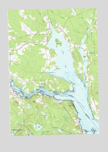
Devils Head, ME USGS Topographic Map
Click on map above to begin viewing in our Map Viewer.

This topographic map contains these locations and features:
Feature Name Type Latitude Longitude GNIS ID View Map
Beaver LakeLakeN45.1328°W67.2095°561933View Map
Calais Middle High SchoolSchoolN45.1641°W67.2417°1909083View Map
Carson HeathLakeN45.1430°W67.1992°563629View Map
City of CalaisCivilN45.1340°W67.2239°582382View Map
Cook CoveBayN45.1292°W67.1483°564313View Map
Devils HeadSummitN45.1536°W67.1626°565076View Map
Elliott FallsFlatN45.1670°W67.2028°580773View Map
Elliott MountainSummitN45.1589°W67.2177°565852View Map
Flowed Land PondsLakeN45.1289°W67.1797°566323View Map
Ford PointCapeN45.1395°W67.1519°566378View Map
Knights PointCapeN45.1670°W67.2364°569252View Map
Miller PointCapeN45.1629°W67.1894°571376View Map
Nash LakeReservoirN45.1254°W67.2229°1774630View Map
Nash Lake DamDamN45.1254°W67.2229°1774629View Map
Pettegrove PointCapeN45.1276°W67.1425°573242View Map
Saint Croix IslandIslandN45.1284°W67.1333°581487View Map
Saint Croix Island International Historic SiteParkN45.1286°W67.1336°581971View Map
Saint Croix Regional Technical Center SchoolSchoolN45.1639°W67.2418°2738062View Map
The NarrowsChannelN45.1634°W67.2258°576857View Map
Todd PointCapeN45.1784°W67.2483°577146View Map
Vose PondReservoirN45.1277°W67.2453°577747View Map
Vose Pond DamDamN45.1288°W67.2492°1774661View Map
Washington County Community CollegeSchoolN45.1655°W67.2433°1909387View Map
Washington County Community College LibraryBuildingN45.1655°W67.2433°1909388View Map
Washington County Technical College Marine Trade CenterBuildingN45.1656°W67.2450°1909389View Map
Whitlocks MillPopulated PlaceN45.1609°W67.2269°578402View Map
Whitlocks Mill Light StationLocaleN45.1629°W67.2272°1909405View Map

Note: Coordinates in the location and feature list above are referenced to NAD83 datum.


Copyright (C) 2008-2024 Ryan Niemi / Sunset Dynamics ... All Rights Reserved