TopoQuest Logo
Do you find TopoQuest useful?
Help keep TopoQuest running and adding new maps/features by donating!
Bitcoin:  19c7KJd3qBynnjoSw5npx9KScwjBe4ifkT
Litecoin:  LXs6TkuXGGXo1vDsWCkWVdjQX94eUKd6ui
Home View Maps Find Maps Find Places Resources & Links


Antioch, Ohio Topographic Map

USGS Map Title: Antioch, OH
USGS Map MRC: 39081F1
DRG (GeoTIFF) Download: o39081f1.tif


Neighboring USGS Topographic Map Quads:


  Lewisville, OH  
39081G2
 

  Woodsfield, OH  
39081G1
 

  Cameron, OH  
39080G8
 

  Graysville, OH  
39081F2
 

  Antioch, OH  
39081F1
 

  Round Bottom, OH  
39080F8
 

  Rinard Mills, OH  
39081E2
 

  New Matamoras, OH  
39081E1
 

  Paden City, WV  
39080E8


Map MRC Location:

N40°
W82°
N40°
W81°
H8 H7 H6 H5 H4 H3 H2 H1
G8 G7 G6 G5 G4 G3 G2 G1
F8 F7 F6 F5 F4 F3 F2 F1
E8 E7 E6 E5 E4 E3 E2 E1
D8 D7 D6 D5 D4 D3 D2 D1
C8 C7 C6 C5 C4 C3 C2 C1
B8 B7 B6 B5 B4 B3 B2 B1
A8 A7 A6 A5 A4 A3 A2 A1
N39°
W82°
N39°
W81°

Antioch, OH USGS 1:24K Topographic Map Preview:
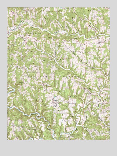
Antioch, OH USGS Topographic Map
Click on map above to begin viewing in our Map Viewer.

This topographic map contains these locations and features:
Feature Name Type Latitude Longitude GNIS ID View Map
AlexisPopulated PlaceN39.6365°W81.0312°1075250View Map
Alexis Post Office (historical)Post OfficeN39.6362°W81.0318°2037264View Map
Alum RunStreamN39.6612°W81.0098°1075259View Map
AntiochPopulated PlaceN39.6601°W81.0679°1075269View Map
Antioch CemeteryCemeteryN39.6648°W81.0693°1963746View Map
Antioch Community Volunteer Fire DepartmentBuildingN39.6633°W81.0680°2550003View Map
Antioch Post OfficePost OfficeN39.6598°W81.0679°2037270View Map
BenwoodPopulated PlaceN39.6859°W81.0004°1075349View Map
Benwood Post Office (historical)Post OfficeN39.6862°W81.0012°2037274View Map
Bondy RidgeRidgeN39.7345°W81.0282°1038188View Map
Coal RunStreamN39.6465°W81.0832°1075597View Map
Cowtail RunStreamN39.6748°W81.1215°1075641View Map
CranenestPopulated PlaceN39.7270°W81.0623°1075644View Map
Dent RidgeRidgeN39.6948°W81.0718°1075703View Map
Dismal CreekStreamN39.6567°W81.0304°1075719View Map
Dogskin RunStreamN39.6376°W81.0409°1075729View Map
Fairview CemeteryCemeteryN39.7140°W81.1012°1075824View Map
Fletcher CemeteryCemeteryN39.7076°W81.0434°1963758View Map
Fletchers ChapelChurchN39.7079°W81.0432°1075861View Map
Foraker BridgeBridgeN39.6554°W81.1212°1051021View Map
FoxtownPopulated PlaceN39.6687°W81.0120°1075872View Map
Frieden RunStreamN39.6379°W81.0329°1075883View Map
Grant HollowValleyN39.7284°W81.0570°1075950View Map
GreenbrierPopulated PlaceN39.6390°W81.1173°1075960View Map
Greenbrier CemeteryCemeteryN39.6406°W81.1187°1963760View Map
Greenbrier RidgeRidgeN39.6431°W81.1176°1077281View Map
GriffithPopulated PlaceN39.7209°W81.1048°1075969View Map
Griffith Post Office (historical)Post OfficeN39.7209°W81.1054°2037311View Map
Griffith RidgeRidgeN39.7192°W81.0565°1075970View Map
Haren RunStreamN39.6501°W81.0898°1076006View Map
Haythorn CemeteryCemeteryN39.6315°W81.0232°1076030View Map
Horse HollowValleyN39.7242°W81.0501°1076080View Map
Jackson HollowValleyN39.7292°W81.0779°1076129View Map
Jackson RidgeRidgeN39.7095°W81.0996°1076132View Map
Jackson Ridge ChurchChurchN39.7184°W81.1029°1076124View Map
Lainges Post OfficePost OfficeN39.7167°W81.0123°2037320View Map
LaingsPopulated PlaceN39.7170°W81.0123°1076200View Map
Laings Presbyterian CemeteryCemeteryN39.7178°W81.0118°1963769View Map
Lake GlenReservoirN39.6653°W81.0672°1075928View Map
Laurel RunStreamN39.6267°W81.0840°1076213View Map
Laurel RunStreamN39.7251°W81.0393°1076214View Map
Lentz CemeteryCemeteryN39.6492°W81.0470°1076235View Map
MechanicsburgPopulated PlaceN39.6462°W81.0843°1076373View Map
Millers ForkStreamN39.6687°W81.0143°1060550View Map
Moffets ChurchChurchN39.7226°W81.0973°1076413View Map
Moffett Methodist CemeteryCemeteryN39.7228°W81.0979°1963777View Map
Monahan CemeteryCemeteryN39.7481°W81.0204°1076414View Map
Monroe CountyCivilN39.7273°W81.0829°1074068View Map
Monroe County Emergency Medical Services Squad 1 AntiochBuildingN39.6633°W81.0680°2550769View Map
Mount Carrick CemeteryCemeteryN39.7493°W81.0535°1077275View Map
Mulberry KnobSummitN39.6931°W81.1123°1076482View Map
Norris CemeteryCemeteryN39.7314°W81.1193°1076522View Map
Old Otts CemeteryCemeteryN39.7101°W81.0432°1076561View Map
Paulas RidgeRidgeN39.7467°W81.0687°1076601View Map
PlainviewPopulated PlaceN39.6790°W81.1054°1076651View Map
Plainview CemeteryCemeteryN39.6781°W81.1065°1963789View Map
Plainview Post Office (historical)Post OfficeN39.6792°W81.1054°2037369View Map
Plum RunStreamN39.6315°W81.0229°1076663View Map
Pratts RunStreamN39.7245°W81.0115°1076686View Map
Pumpkin RidgeRidgeN39.6729°W81.0304°1076693View Map
Township of GreenCivilN39.7073°W81.0032°1086651View Map
Township of PerryCivilN39.6580°W81.0758°1086656View Map
Trail RunStreamN39.6315°W81.0507°1077067View Map
Unity Baptist CemeteryCemeteryN39.6428°W81.0507°1963807View Map
Unity Baptist ChurchChurchN39.6431°W81.0512°1077105View Map
Village of AntiochCivilN39.6611°W81.0670°2397969View Map
Walnutcamp RunStreamN39.6531°W81.0182°1077136View Map
West Union CemeteryCemeteryN39.6606°W81.0123°1963808View Map
West Union ChurchChurchN39.6606°W81.0129°1077162View Map
Wildcat RunStreamN39.6412°W81.0393°1077189View Map
Wolfpen RunStreamN39.7359°W81.1065°1077225View Map
Woods RunStreamN39.6845°W81.0029°1077230View Map
Woodsfield ChurchChurchN39.7465°W81.0826°1077232View Map

Note: Coordinates in the location and feature list above are referenced to NAD83 datum.


Copyright (C) 2008-2024 Ryan Niemi / Sunset Dynamics ... All Rights Reserved