TopoQuest Logo
Do you find TopoQuest useful?
Help keep TopoQuest running and adding new maps/features by donating!
Bitcoin:  19c7KJd3qBynnjoSw5npx9KScwjBe4ifkT
Litecoin:  LXs6TkuXGGXo1vDsWCkWVdjQX94eUKd6ui
Home View Maps Find Maps Find Places Resources & Links


Concord, Tennessee Topographic Map

USGS Map Title: Concord, TN
USGS Map MRC: 35084G2
DRG (GeoTIFF) Download: o35084g2.tif


Neighboring USGS Topographic Map Quads:


  Bethel Valley, TN  
35084H3
 

  Lovell, TN  
35084H2
 

  Bearden, TN  
35084H1
 

  Lenoir City, TN  
35084G3
 

  Concord, TN  
35084G2
 

  Louisville, TN  
35084G1
 

  Loudon, TN  
35084F3
 

  Meadow, TN  
35084F2
 

  Binfield, TN  
35084F1


Map MRC Location:

N36°
W85°
N36°
W84°
H8 H7 H6 H5 H4 H3 H2 H1
G8 G7 G6 G5 G4 G3 G2 G1
F8 F7 F6 F5 F4 F3 F2 F1
E8 E7 E6 E5 E4 E3 E2 E1
D8 D7 D6 D5 D4 D3 D2 D1
C8 C7 C6 C5 C4 C3 C2 C1
B8 B7 B6 B5 B4 B3 B2 B1
A8 A7 A6 A5 A4 A3 A2 A1
N35°
W85°
N35°
W84°

Concord, TN USGS 1:24K Topographic Map Preview:
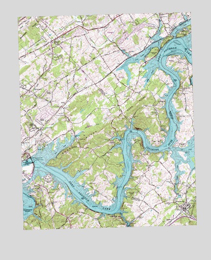
Concord, TN USGS Topographic Map
Click on map above to begin viewing in our Map Viewer.

This topographic map contains these locations and features:
Feature Name Type Latitude Longitude GNIS ID View Map
Aichton Memorial Baptist ChurchChurchN35.8690°W84.1416°1321388View Map
AntiochPopulated PlaceN35.7565°W84.2180°1309511View Map
Antioch Baptist ChurchChurchN35.7567°W84.2180°1304851View Map
Audubon HillsPopulated PlaceN35.8595°W84.1652°1312227View Map
Baker HollowValleyN35.7597°W84.2432°1276177View Map
Beals ChapelChurchN35.7762°W84.2010°1305007View Map
Bell Canton ShoalsBarN35.7898°W84.2380°1643256View Map
Belle-AirePopulated PlaceN35.8701°W84.1655°1276960View Map
Big Island (historical)IslandN35.7954°W84.1727°1309516View Map
Booth ChapelChurchN35.7712°W84.2319°1305352View Map
BoydPopulated PlaceN35.8459°W84.1769°1314720View Map
Boyd School (historical)SchoolN35.8265°W84.1702°1321420View Map
Burnett School (historical)SchoolN35.8017°W84.2277°1309517View Map
Bussell ShoalsBarN35.7834°W84.2263°1309518View Map
BusselltownPopulated PlaceN35.7754°W84.2344°1279156View Map
Busselltown School (historical)SchoolN35.7751°W84.2360°1309519View Map
Calloway Island (historical)IslandN35.8526°W84.1385°1312243View Map
Calloway RidgeRidgeN35.8584°W84.1432°1279338View Map
Cane Island (historical)IslandN35.7867°W84.1732°1309526View Map
Canton HollowValleyN35.8735°W84.1291°1279620View Map
Cedar HillsPopulated PlaceN35.8195°W84.2269°1309524View Map
Cedar Hills Golf and Country ClubLocaleN35.8173°W84.2210°1305781View Map
Chota ShoalsBarN35.8001°W84.1405°1645093View Map
Choto BendBendN35.7998°W84.1524°1305914View Map
Choto ChurchChurchN35.8212°W84.1541°1314117View Map
Choto EstatesPopulated PlaceN35.8217°W84.1471°1314842View Map
Choto HillsPopulated PlaceN35.8148°W84.1355°1280511View Map
Choto MarinaLocaleN35.8065°W84.1457°1305915View Map
City of FriendsvilleCivilN35.7549°W84.1341°2403666View Map
Cloyd CreekStreamN35.7592°W84.1813°1305994View Map
Commissioner District 5CivilN35.8658°W84.1487°2464463View Map
Commissioner District 6CivilN35.8028°W84.2057°2464554View Map
ConcordPopulated PlaceN35.8687°W84.1419°1281059View Map
Concord DockLocaleN35.8654°W84.1310°1281073View Map
Concord ParkParkN35.8631°W84.1305°1281075View Map
Concord QuarryMineN35.8587°W84.1438°1321463View Map
Concord School (historical)SchoolN35.8701°W84.1407°1321464View Map
Concords WoodsPopulated PlaceN35.8729°W84.1374°1312256View Map
Coulter ShoalsBarN35.7924°W84.1741°1309525View Map
Coulter ShoalsPopulated PlaceN35.7998°W84.1830°1281376View Map
CusickPopulated PlaceN35.8512°W84.2216°1281906View Map
DiscoPopulated PlaceN35.7859°W84.1582°1314948View Map
Dixie Lee Baptist ChurchChurchN35.8556°W84.2277°1643273View Map
Dixie Lee JunctionPopulated PlaceN35.8606°W84.2258°1282515View Map
Dry CreekStreamN35.7623°W84.2030°1282916View Map
Duff SpringSpringN35.7984°W84.2139°1283075View Map
Dunn RidgeRidgeN35.8095°W84.1877°1283212View Map
Earley Island (historical)IslandN35.8034°W84.1419°1312265View Map
Early CemeteryCemeteryN35.8081°W84.1474°1283309View Map
Ebb and Flow SpringSpringN35.8097°W84.2354°1283453View Map
FordPopulated PlaceN35.8317°W84.2433°1284559View Map
Forest HeightsPopulated PlaceN35.8276°W84.2358°1315068View Map
Fork CreekStreamN35.7884°W84.2333°1284617View Map
Fort Loudon EstatesPopulated PlaceN35.7815°W84.2319°1284669View Map
Fort Loudoun DamDamN35.7920°W84.2433°1306451View Map
Fox DenPopulated PlaceN35.8698°W84.1946°1312273View Map
Friends ChurchChurchN35.7612°W84.1374°1308243View Map
FriendsvillePopulated PlaceN35.7604°W84.1357°1284953View Map
Friendsville AcademySchoolN35.7601°W84.1327°1642468View Map
Friendsville CemeteryCemeteryN35.7606°W84.1382°1642469View Map
Friendsville ChurchChurchN35.7590°W84.1327°1308241View Map
Friendsville ChurchChurchN35.7631°W84.1307°1308242View Map
Friendsville Elementary SchoolSchoolN35.7612°W84.1299°1307975View Map
Friendsville High School (historical)SchoolN35.7620°W84.1307°1642470View Map
Friendsville Post OfficePost OfficeN35.7609°W84.1355°1649463View Map
Friendsville Volunteer Fire DepartmentBuildingN35.7595°W84.1331°2654807View Map
Gallagher CreekStreamN35.7937°W84.1394°1314125View Map
Gravelly HillsPopulated PlaceN35.8290°W84.1324°1285939View Map
Greenback Fire and Rescue Station 3BuildingN35.7579°W84.2201°2654982View Map
Hardin EstatesPopulated PlaceN35.8084°W84.2399°1286831View Map
Hardin SpringSpringN35.8094°W84.2369°1286837View Map
Highland HillsPopulated PlaceN35.8062°W84.2485°1309541View Map
Highland Hills Church of GodChurchN35.8045°W84.2458°1643282View Map
Holder BranchStreamN35.8448°W84.1496°1288027View Map
Ish CemeteryCemeteryN35.7923°W84.1446°1289074View Map
Ish CreekStreamN35.7954°W84.1421°1289075View Map
Ishs Fort (historical)MilitaryN35.7889°W84.1417°1646806View Map
J Carmichael Greer BridgeBridgeN35.7909°W84.2424°1289136View Map
Jackson CemeteryCemeteryN35.7798°W84.2305°1289201View Map
Keener CemeteryCemeteryN35.8059°W84.1821°1289960View Map
KingsgatePopulated PlaceN35.8612°W84.1741°1312334View Map
Knoxville YMCA CampLocaleN35.7779°W84.1832°1649967View Map
Lakeview CemeteryCemeteryN35.8015°W84.2349°1290520View Map
Lee Heights ChurchChurchN35.8270°W84.2333°1290957View Map
Lee SpringSpringN35.8025°W84.2077°1290964View Map
Leeper BluffCliffN35.7634°W84.1785°1290974View Map
Leeper CemeteryCemeteryN35.7609°W84.1791°1290976View Map
Leepers Ferry (historical)LocaleN35.7598°W84.1832°1643289View Map
Lenoir City MarinaLocaleN35.7973°W84.2380°1309559View Map
Lenoir City ParkParkN35.7990°W84.2335°1291020View Map
Little Turkey CreekStreamN35.8567°W84.1513°1291698View Map
Long Tom CemeteryCemeteryN35.8270°W84.1702°1292013View Map
Loudon County Fire Rescue Station 2BuildingN35.8107°W84.2335°2654434View Map
Macs DockLocaleN35.7526°W84.1724°1292464View Map
MartelPopulated PlaceN35.8217°W84.2196°1315471View Map
Martel ChurchChurchN35.8081°W84.2130°1292777View Map
Martel ChurchChurchN35.8251°W84.2277°1292778View Map
Martel EstatesPopulated PlaceN35.8120°W84.2344°1292779View Map
Martel Estates EastPopulated PlaceN35.8181°W84.2319°1309577View Map
Martel School (historical)SchoolN35.8084°W84.2133°1309578View Map
Massingale AirportAirportN35.7642°W84.1880°2675574View Map
McNeely SpringSpringN35.8323°W84.2394°1293441View Map
McReynolds Island (historical)IslandN35.8534°W84.1310°1312350View Map
Mizell BluffCliffN35.7662°W84.2405°1309579View Map
Mizell SpringSpringN35.7623°W84.2421°1294124View Map
Muddy CreekStreamN35.7912°W84.2474°1295039View Map
Muddy Creek School (historical)SchoolN35.8270°W84.2335°1309576View Map
Noah's Ark FarmLocaleN35.8461°W84.2328°2652550View Map
North Fork Turkey CreekStreamN35.8740°W84.1482°1295919View Map
Norton Islands (historical)IslandN35.7890°W84.2416°1309584View Map
Parks BendBendN35.7998°W84.1660°1296844View Map
Parks Ferry (historical)LocaleN35.8065°W84.1705°1643309View Map
Point HarborPopulated PlaceN35.7876°W84.2235°1309592View Map
Possum Valley RidgeRidgeN35.8448°W84.2424°1309591View Map
Prater CemeteryCemeteryN35.7649°W84.1881°1298456View Map
Praters Ferry (historical)CrossingN35.8306°W84.1366°1312366View Map
Raby AirparkAirportN35.8422°W84.1814°2675553View Map
Rio VistaPopulated PlaceN35.7765°W84.1666°1308011View Map
Rural / Metro Fire Department Knoxville 14BuildingN35.8635°W84.2228°1321502View Map
Saltpeter BluffCliffN35.8073°W84.1646°1300601View Map
Scenic Point EstatesPopulated PlaceN35.7973°W84.1360°1315880View Map
Sequoyah HeightsPopulated PlaceN35.7701°W84.1677°1315889View Map
Shady GrovePopulated PlaceN35.8217°W84.1791°1647615View Map
Shady Grove ChurchChurchN35.8215°W84.1785°1301174View Map
Sinking CreekStreamN35.8601°W84.1369°1270385View Map
Sister Island ShoalsBarN35.7631°W84.1977°1643315View Map
Sister Islands (historical)IslandN35.7637°W84.2007°1309606View Map
Smoky Landing DockLocaleN35.7748°W84.1380°1314307View Map
South Holston ChurchChurchN35.7751°W84.2363°1303729View Map
Taliaferro BendBendN35.8465°W84.1363°1303990View Map
Taliaferro Island (historical)IslandN35.8340°W84.1374°1312383View Map
Tom Carson SpringSpringN35.8246°W84.2155°1643320View Map
Town of FarragutCivilN35.8731°W84.1821°2406494View Map
Turkey CreekStreamN35.8537°W84.1474°1273010View Map
Turkey Creek ShoalsBarN35.8570°W84.1307°1645118View Map
Union ChurchChurchN35.8742°W84.1996°1273202View Map
Union Valley School (historical)SchoolN35.8120°W84.2119°1309610View Map
Vinegar ValleyValleyN35.7823°W84.1270°1273468View Map
VirtuePopulated PlaceN35.8565°W84.1785°1273483View Map
Virtue ChurchChurchN35.8512°W84.1744°1321749View Map
WaterhavenPopulated PlaceN35.7959°W84.1682°1308032View Map
WatershawPopulated PlaceN35.7890°W84.1444°1308033View Map
Wesleyan SchoolSchoolN35.8676°W84.1352°1321756View Map
Yarberry Peninsular Recreation AreaParkN35.7709°W84.2160°1309616View Map

Note: Coordinates in the location and feature list above are referenced to NAD83 datum.


Copyright (C) 2008-2024 Ryan Niemi / Sunset Dynamics ... All Rights Reserved