TopoQuest Logo
Do you find TopoQuest useful?
Help keep TopoQuest running and adding new maps/features by donating!
Bitcoin:  19c7KJd3qBynnjoSw5npx9KScwjBe4ifkT
Litecoin:  LXs6TkuXGGXo1vDsWCkWVdjQX94eUKd6ui
Home View Maps Find Maps Find Places Resources & Links


Columbia City, Indiana Topographic Map

USGS Map Title: Columbia City, IN
USGS Map MRC: 41085B4
DRG (GeoTIFF) Download: o41085b4.tif


Neighboring USGS Topographic Map Quads:


  Ormas, IN  
41085C5
 

  Merriam, IN  
41085C4
 

  Ege, IN  
41085C3
 

  Lorane, IN  
41085B5
 

  Columbia City, IN  
41085B4
 

  Churubusco, IN  
41085B3
 

  South Whitley East, IN  
41085A5
 

  Laud, IN  
41085A4
 

  Arcola, IN  
41085A3


Map MRC Location:

N42°
W86°
N42°
W85°
H8 H7 H6 H5 H4 H3 H2 H1
G8 G7 G6 G5 G4 G3 G2 G1
F8 F7 F6 F5 F4 F3 F2 F1
E8 E7 E6 E5 E4 E3 E2 E1
D8 D7 D6 D5 D4 D3 D2 D1
C8 C7 C6 C5 C4 C3 C2 C1
B8 B7 B6 B5 B4 B3 B2 B1
A8 A7 A6 A5 A4 A3 A2 A1
N41°
W86°
N41°
W85°

Columbia City, IN USGS 1:24K Topographic Map Preview:
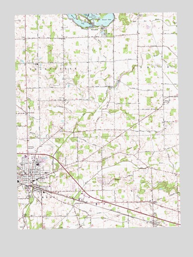
Columbia City, IN USGS Topographic Map
Click on map above to begin viewing in our Map Viewer.

This topographic map contains these locations and features:
Feature Name Type Latitude Longitude GNIS ID View Map
Blue Babe BranchStreamN41.1723°W85.4672°431214View Map
Blue River ChurchChurchN41.2073°W85.4272°431247View Map
Chapine ReserveReserveN41.1667°W85.3764°446646View Map
City of Columbia CityCivilN41.1612°W85.4855°2393606View Map
CoessePopulated PlaceN41.1278°W85.3953°432728View Map
Coesse ChurchChurchN41.1325°W85.3953°432729View Map
Coesse CornersPopulated PlaceN41.1400°W85.3958°432730View Map
Cole DitchCanalN41.2087°W85.4683°432755View Map
CollinsPopulated PlaceN41.1975°W85.3866°432790View Map
Columbia CityPopulated PlaceN41.1573°W85.4883°432816View Map
Columbia City Fire DepartmentBuildingN41.1562°W85.4904°2625532View Map
Columbia City Joint High SchoolSchoolN41.1631°W85.4839°447497View Map
Columbia City Police DepartmentBuildingN41.1564°W85.4902°2758034View Map
Columbia Township Fire DepartmentBuildingN41.1466°W85.4909°2625799View Map
Columbia Township SchoolSchoolN41.1331°W85.4900°447496View Map
CrescoPopulated PlaceN41.2359°W85.4916°433111View Map
Devol FieldParkN41.1562°W85.4991°433513View Map
Five PointsPopulated PlaceN41.1928°W85.4916°434547View Map
Garrison CemeteryCemeteryN41.1809°W85.3963°434975View Map
Karen LakeLakeN41.2389°W85.4324°437167View Map
Krider DitchCanalN41.1759°W85.3964°437456View Map
Little Cedar LakeLakeN41.2484°W85.4397°438008View Map
Little LakeLakeN41.2487°W85.4043°438086View Map
Mary Raber Elementary SchoolSchoolN41.1578°W85.4780°441713View Map
Miller DitchCanalN41.1695°W85.4347°439216View Map
Morsche ParkParkN41.1617°W85.4708°439469View Map
Mossman DitchCanalN41.1334°W85.4428°439504View Map
Mowrey DitchCanalN41.1403°W85.4053°439789View Map
Mud RunStreamN41.2448°W85.3941°450570View Map
Nolt CemeteryCemeteryN41.1267°W85.4964°440199View Map
Oak Grove ChurchChurchN41.1262°W85.4519°440413View Map
Parkview Whitley HospitalHospitalN41.1588°W85.4646°2660496View Map
Phillip DitchCanalN41.1481°W85.4955°441082View Map
Rittenhouse DitchCanalN41.1959°W85.4622°442065View Map
Rouch DitchCanalN41.1923°W85.4186°442342View Map
Round LakeLakeN41.2462°W85.4293°442351View Map
Saint Johns ChurchChurchN41.2359°W85.4628°442598View Map
Seeks Village Reserve (historical)CivilN41.1500°W85.4166°446647View Map
Shriner LakeLakeN41.2462°W85.4507°443459View Map
Solon DitchCanalN41.1450°W85.3775°443760View Map
South Park CemeteryCemeteryN41.1398°W85.4938°443837View Map
Terry's AirportAirportN41.1702°W85.4208°2676920View Map
Thorn CreekStreamN41.2064°W85.4291°444728View Map
Thorn Creek ChurchChurchN41.2006°W85.4630°444730View Map
Thorncreek Center SchoolSchoolN41.2209°W85.4833°447501View Map
Thorncreek Township Fire DepartmentBuildingN41.2372°W85.4764°2626131View Map
Township of ThorncreekCivilN41.2217°W85.4818°453893View Map
Township of UnionCivilN41.1341°W85.3951°453940View Map
Tri-LakesPopulated PlaceN41.2459°W85.4419°444874View Map
Union Township Volunteer Fire DepartmentBuildingN41.1276°W85.3948°2625985View Map
Walnut CornersPopulated PlaceN41.1328°W85.4964°445408View Map
West Ward SchoolSchoolN41.1578°W85.4936°445824View Map
Whitley County Sheriff's OfficeBuildingN41.1556°W85.4888°2758021View Map
Wigent AirportAirportN41.2085°W85.4614°2676909View Map

Note: Coordinates in the location and feature list above are referenced to NAD83 datum.


Copyright (C) 2008-2024 Ryan Niemi / Sunset Dynamics ... All Rights Reserved