TopoQuest Logo
Do you find TopoQuest useful?
Help keep TopoQuest running and adding new maps/features by donating!
Bitcoin:  19c7KJd3qBynnjoSw5npx9KScwjBe4ifkT
Litecoin:  LXs6TkuXGGXo1vDsWCkWVdjQX94eUKd6ui
Home View Maps Find Maps Find Places Resources & Links


Cliffield Mountain, North Carolina Topographic Map

USGS Map Title: Cliffield Mountain, NC
USGS Map MRC: 35082C3
DRG (GeoTIFF) Download: o35082c3.tif


Neighboring USGS Topographic Map Quads:


  Fruitland, NC  
35082D4
 

  Bat Cave, NC  
35082D3
 

  Lake Lure, NC  
35082D2
 

  Hendersonville, NC  
35082C4
 

  Cliffield Mountain, NC  
35082C3
 

  Mill Spring, NC  
35082C2
 

  Zirconia, NC  
35082B4
 

  Saluda, NC  
35082B3
 

  Landrum, SC  
35082B2


Map MRC Location:

N36°
W83°
N36°
W82°
H8 H7 H6 H5 H4 H3 H2 H1
G8 G7 G6 G5 G4 G3 G2 G1
F8 F7 F6 F5 F4 F3 F2 F1
E8 E7 E6 E5 E4 E3 E2 E1
D8 D7 D6 D5 D4 D3 D2 D1
C8 C7 C6 C5 C4 C3 C2 C1
B8 B7 B6 B5 B4 B3 B2 B1
A8 A7 A6 A5 A4 A3 A2 A1
N35°
W83°
N35°
W82°

Cliffield Mountain, NC USGS 1:24K Topographic Map Preview:
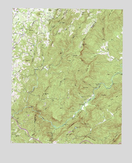
Cliffield Mountain, NC USGS Topographic Map
Click on map above to begin viewing in our Map Viewer.

This topographic map contains these locations and features:
Feature Name Type Latitude Longitude GNIS ID View Map
Annie MountainSummitN35.3334°W82.3221°1018829View Map
BaxterPopulated PlaceN35.3173°W82.3479°1018988View Map
Big BranchStreamN35.3698°W82.3343°981335View Map
Blue RidgePopulated PlaceN35.3504°W82.3629°1019229View Map
Bradley CemeteryCemeteryN35.2796°W82.3034°981801View Map
Bradley CemeteryCemeteryN35.2937°W82.2857°981802View Map
Bradley FallsFallsN35.2684°W82.2917°981807View Map
Bradley MountainSummitN35.3521°W82.3237°981811View Map
Brushy MountainSummitN35.2576°W82.3079°1019337View Map
Byers CreekStreamN35.3726°W82.3393°982359View Map
Camp CreekStreamN35.2712°W82.3373°982523View Map
Casey BranchStreamN35.2704°W82.2937°982727View Map
Chestnut MountainSummitN35.2523°W82.2779°1019643View Map
ChimneytopSummitN35.2951°W82.2740°1019664View Map
Cliffield MountainSummitN35.3418°W82.2962°1019698View Map
Copper FordPopulated PlaceN35.3612°W82.3187°1019778View Map
Cove CreekStreamN35.2859°W82.2929°983619View Map
Cove MountainSummitN35.2657°W82.3071°1019811View Map
Dana Census Designated PlaceCensusN35.3240°W82.3722°2584314View Map
Dana SchoolSchoolN35.3382°W82.3735°983936View Map
Deep GapGapN35.3315°W82.3059°984072View Map
Edith Grove ChurchChurchN35.3709°W82.3687°984642View Map
Gadd CreekStreamN35.2879°W82.2915°985510View Map
Green River CoveValleyN35.3164°W82.2522°986084View Map
Harm CreekStreamN35.3329°W82.2662°986413View Map
HoracePopulated PlaceN35.3718°W82.2965°1020833View Map
Hungry RiverStreamN35.2832°W82.3585°987243View Map
Jones - Price CemeteryCemeteryN35.2934°W82.2965°987766View Map
Jones CemeteryCemeteryN35.3675°W82.3315°987722View Map
Jones KnobSummitN35.3734°W82.3318°1020981View Map
Kings MountainSummitN35.3262°W82.3593°988005View Map
Lamb MountainSummitN35.3743°W82.3223°1021091View Map
Larry Ball DamDamN35.3101°W82.3682°998780View Map
Larry Ball LakeReservoirN35.3108°W82.3686°998781View Map
Laurel BranchStreamN35.3012°W82.2807°988171View Map
Laurel MountainSummitN35.3065°W82.3184°1021110View Map
Little Cove CreekStreamN35.2893°W82.2873°988578View Map
Little Hungry RiverStreamN35.3187°W82.3468°988669View Map
Livert MountainSummitN35.3612°W82.3079°1021249View Map
Long RidgeRidgeN35.2901°W82.3098°988998View Map
Low GapGapN35.3559°W82.3157°989076View Map
Macedonia ChurchChurchN35.2565°W82.3696°989177View Map
McCraw MountainSummitN35.3193°W82.2871°1021384View Map
Mill CornerPopulated PlaceN35.3354°W82.3543°1021450View Map
Mill CreekStreamN35.2782°W82.3701°989945View Map
Miller MountainSummitN35.2557°W82.2568°1021468View Map
Mount ValleyPopulated PlaceN35.2859°W82.2940°1021562View Map
Palmetto LakeReservoirN35.2618°W82.3082°998692View Map
Palmetto LakeReservoirN35.2649°W82.3016°991804View Map
Palmetto Lake Lower DamDamN35.2651°W82.3015°998697View Map
Palmetto Lake Upper DamDamN35.2618°W82.3082°998691View Map
Patty CemeteryCemeteryN35.3043°W82.2784°991946View Map
Pegram LakeReservoirN35.2759°W82.3550°998726View Map
Pegram Lake DamDamN35.2768°W82.3548°998725View Map
Pilot MountainSummitN35.3690°W82.3462°1021903View Map
Piney MountainSummitN35.2923°W82.2559°1021959View Map
Piney MountainSummitN35.3543°W82.3562°1021960View Map
Pulliam CreekStreamN35.2779°W82.3421°992896View Map
Raccoon MountainSummitN35.3015°W82.2948°1022133View Map
Rich MountainSummitN35.2976°W82.3360°1022262View Map
Rich Mountain GapGapN35.2957°W82.3376°993302View Map
SacononPopulated PlaceN35.3404°W82.3507°1022455View Map
Saconon CreekStreamN35.3418°W82.3487°993836View Map
Stepp CemeteryCemeteryN35.3412°W82.3418°995473View Map
The NarrowsGapN35.2796°W82.3468°995993View Map
Township of Blue RidgeCivilN35.3274°W82.3701°1026786View Map
Township of SaludaCivilN35.2558°W82.3095°1027071View Map
Tumblebug CreekStreamN35.3184°W82.3479°1023000View Map
Union HillPopulated PlaceN35.3515°W82.3401°1023040View Map
Wildcat SpurRidgeN35.3737°W82.2607°997318View Map

Note: Coordinates in the location and feature list above are referenced to NAD83 datum.


Copyright (C) 2008-2024 Ryan Niemi / Sunset Dynamics ... All Rights Reserved