TopoQuest Logo
Do you find TopoQuest useful?
Help keep TopoQuest running and adding new maps/features by donating!
Bitcoin:  19c7KJd3qBynnjoSw5npx9KScwjBe4ifkT
Litecoin:  LXs6TkuXGGXo1vDsWCkWVdjQX94eUKd6ui
Home View Maps Find Maps Find Places Resources & Links


Clayton, Tennessee Topographic Map

USGS Map Title: Clayton, TN
USGS Map MRC: 36089D2
DRG (GeoTIFF) Download: o36089d2.tif


Neighboring USGS Topographic Map Quads:


  Bondurant, KY  
36089E3
 

  Hickman, KY  
36089E2
 

  Cayce, KY  
36089E1
 

  Samburg, TN  
36089D3
 

  Clayton, TN  
36089D2
 

  Union City, TN  
36089D1
 

  Hornbeak, TN  
36089C3
 

  Obion, TN  
36089C2
 

  Rives, TN  
36089C1


Map MRC Location:

N37°
W90°
N37°
W89°
H8 H7 H6 H5 H4 H3 H2 H1
G8 G7 G6 G5 G4 G3 G2 G1
F8 F7 F6 F5 F4 F3 F2 F1
E8 E7 E6 E5 E4 E3 E2 E1
D8 D7 D6 D5 D4 D3 D2 D1
C8 C7 C6 C5 C4 C3 C2 C1
B8 B7 B6 B5 B4 B3 B2 B1
A8 A7 A6 A5 A4 A3 A2 A1
N36°
W90°
N36°
W89°

Clayton, TN USGS 1:24K Topographic Map Preview:
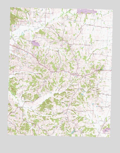
Clayton, TN USGS Topographic Map
Click on map above to begin viewing in our Map Viewer.

This topographic map contains these locations and features:
Feature Name Type Latitude Longitude GNIS ID View Map
Antioch CemeteryCemeteryN36.4701°W89.1867°1326710View Map
Antioch ChurchChurchN36.4690°W89.1862°1326777View Map
BeechLocaleN36.4045°W89.1365°1276788View Map
Beech CemeteryCemeteryN36.4048°W89.1356°1326711View Map
Beech ChapelChurchN36.4051°W89.1367°1647538View Map
Bethel Baptist ChurchChurchN36.3976°W89.1878°1305149View Map
Cane CreekStreamN36.4090°W89.2376°1279509View Map
ClaytonPopulated PlaceN36.4592°W89.2387°1280636View Map
CrystalPopulated PlaceN36.4628°W89.1756°1281778View Map
Cub BranchStreamN36.4981°W89.1512°1281788View Map
DixiePopulated PlaceN36.4287°W89.2059°1314260View Map
Dixie Division (historical)CensusN36.4456°W89.1987°1648894View Map
Dixie School (historical)SchoolN36.4278°W89.2073°1320456View Map
Englewood LakeReservoirN36.3798°W89.1702°1283792View Map
Englewood Lake DamDamN36.3784°W89.1717°1302557View Map
FremontPopulated PlaceN36.4381°W89.1976°1284901View Map
Fremont CemeteryCemeteryN36.4359°W89.1753°1326718View Map
Fremont Church of ChristChurchN36.4362°W89.1751°1325950View Map
Garrison's Poultry FarmLocaleN36.3956°W89.2281°2635243View Map
Hamblin BranchStreamN36.4778°W89.2273°1286625View Map
Logan HillSummitN36.4412°W89.1401°1291823View Map
Mathis HillSummitN36.4584°W89.1901°1292936View Map
Mount Ararat CemeteryCemeteryN36.3786°W89.1606°2775773View Map
Mount Ararat ChurchChurchN36.3790°W89.1598°1294549View Map
Mount Olive ChurchChurchN36.4617°W89.1765°1294714View Map
Obion County Home (historical)BuildingN36.4170°W89.1301°1320481View Map
Old FremontPopulated PlaceN36.4362°W89.1728°1296310View Map
Old Republican ChurchChurchN36.4401°W89.1428°1296356View Map
ProtemusPopulated PlaceN36.4028°W89.2359°1311841View Map
Protemus Cumberland Presbyterian ChurchChurchN36.4037°W89.2370°1325954View Map
Reelfoot ChurchChurchN36.4706°W89.2487°1299170View Map
Reelfoot Indian Creek Dam Number FifteenDamN36.4876°W89.2275°1302622View Map
Reelfoot Indian Creek Dam Number FourteenDamN36.4867°W89.2151°1302621View Map
Reelfoot Indian Creek Dam Number TenDamN36.4984°W89.1684°1302641View Map
Reelfoot Indian Creek Number Fifteen LakeReservoirN36.4867°W89.2267°1307207View Map
Reelfoot Indian Creek Number Fourteen LakeReservoirN36.4867°W89.2151°1307206View Map
Reelfoot Indian Creek Number Ten LakeReservoirN36.4980°W89.1585°1302642View Map
Reelfoot Indian Creek Watershed Number Seven ReservoirReservoirN36.4651°W89.2184°1302606View Map
Rockspring BranchStreamN36.3823°W89.1395°1299831View Map
Salem CemeteryCemeteryN36.4603°W89.1256°1300542View Map
Sanders ChapelChurchN36.4215°W89.1426°1300697View Map
Sanders Chapel CemeteryCemeteryN36.4203°W89.1431°2775772View Map
Scawley CreekStreamN36.4015°W89.2220°1300872View Map
Snapneck CreekStreamN36.4964°W89.1800°503846View Map
Snow BranchStreamN36.4153°W89.1945°1270774View Map
Taylor CreekStreamN36.4776°W89.2231°1272229View Map
Tull CreekStreamN36.4831°W89.2111°505561View Map

Note: Coordinates in the location and feature list above are referenced to NAD83 datum.


Copyright (C) 2008-2024 Ryan Niemi / Sunset Dynamics ... All Rights Reserved