TopoQuest Logo
Do you find TopoQuest useful?
Help keep TopoQuest running and adding new maps/features by donating!
Bitcoin:  19c7KJd3qBynnjoSw5npx9KScwjBe4ifkT
Litecoin:  LXs6TkuXGGXo1vDsWCkWVdjQX94eUKd6ui
Home View Maps Find Maps Find Places Resources & Links


Clarence, Missouri Topographic Map

USGS Map Title: Clarence, MO
USGS Map MRC: 39092F3
DRG (GeoTIFF) Download: o39092f3.tif


Neighboring USGS Topographic Map Quads:


  Axtell, MO  
39092G4
 

  Redman, MO  
39092G3
 

  Hagers Grove, MO  
39092G2
 

  Macon, MO  
39092F4
 

  Clarence, MO  
39092F3
 

  Lentner, MO  
39092F2
 

  Jacksonville, MO  
39092E4
 

  Duncans Bridge, MO  
39092E3
 

  Woodlawn, MO  
39092E2


Map MRC Location:

N40°
W93°
N40°
W92°
H8 H7 H6 H5 H4 H3 H2 H1
G8 G7 G6 G5 G4 G3 G2 G1
F8 F7 F6 F5 F4 F3 F2 F1
E8 E7 E6 E5 E4 E3 E2 E1
D8 D7 D6 D5 D4 D3 D2 D1
C8 C7 C6 C5 C4 C3 C2 C1
B8 B7 B6 B5 B4 B3 B2 B1
A8 A7 A6 A5 A4 A3 A2 A1
N39°
W93°
N39°
W92°

Clarence, MO USGS 1:24K Topographic Map Preview:
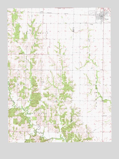
Clarence, MO USGS Topographic Map
Click on map above to begin viewing in our Map Viewer.

This topographic map contains these locations and features:
Feature Name Type Latitude Longitude GNIS ID View Map
AnabelPopulated PlaceN39.7459°W92.3332°740624View Map
Bee BranchStreamN39.7052°W92.3524°713854View Map
Bethlehem ChurchChurchN39.7073°W92.3574°714105View Map
Bohannon SchoolSchoolN39.6631°W92.3280°734185View Map
Church of GodChurchN39.6670°W92.2605°735558View Map
City of ClarenceCivilN39.7432°W92.2601°2393533View Map
ClarencePopulated PlaceN39.7420°W92.2585°715868View Map
Clarence City Fire DepartmentBuildingN39.7432°W92.2613°2621062View Map
Clarence Police DepartmentBuildingN39.7433°W92.2622°2752148View Map
Clarence Post OfficePost OfficeN39.7419°W92.2623°2782773View Map
EnterprisePopulated PlaceN39.6489°W92.2602°740834View Map
Graves ChapelChurchN39.6809°W92.3338°718750View Map
Hoover CreekStreamN39.6342°W92.3421°719787View Map
Lily Dale School (historical)SchoolN39.6484°W92.2799°733562View Map
Longville (historical)Populated PlaceN39.6920°W92.3349°759902View Map
Narrows CreekStreamN39.6589°W92.3668°723121View Map
Prairie View School (historical)SchoolN39.7123°W92.3260°734187View Map
Saint Patricks CemeteryCemeteryN39.7353°W92.2716°725858View Map
Saint Patricks Roman Catholic Church (historical)ChurchN39.7353°W92.2696°733563View Map
Sale School (historical)SchoolN39.6778°W92.2705°733561View Map
Taylor School (historical)SchoolN39.7064°W92.2693°733560View Map
Township of Middle ForkCivilN39.6494°W92.3543°766972View Map
Township of Round GroveCivilN39.7361°W92.3512°766976View Map
Union ChurchChurchN39.6631°W92.2607°735895View Map
Waddell School (historical)SchoolN39.6792°W92.3646°733738View Map
Wilson and Evans Mill (historical)LocaleN39.7473°W92.2771°733584View Map
Winn BranchStreamN39.6570°W92.3530°729006View Map
Zion Methodist Church (historical)ChurchN39.6886°W92.2607°733564View Map

Note: Coordinates in the location and feature list above are referenced to NAD83 datum.


Copyright (C) 2008-2024 Ryan Niemi / Sunset Dynamics ... All Rights Reserved