TopoQuest Logo
Do you find TopoQuest useful?
Help keep TopoQuest running and adding new maps/features by donating!
Bitcoin:  19c7KJd3qBynnjoSw5npx9KScwjBe4ifkT
Litecoin:  LXs6TkuXGGXo1vDsWCkWVdjQX94eUKd6ui
Home View Maps Find Maps Find Places Resources & Links


Channahon, Illinois Topographic Map

USGS Map Title: Channahon, IL
USGS Map MRC: 41088D2
DRG (GeoTIFF) Download: o41088d2.tif


Neighboring USGS Topographic Map Quads:


  Yorkville SE, IL  
41088E3
 

  Plainfield, IL  
41088E2
 

  Joliet, IL  
41088E1
 

  Minooka, IL  
41088D3
 

  Channahon, IL  
41088D2
 

  Elwood, IL  
41088D1
 

  Coal City, IL  
41088C3
 

  Wilmington, IL  
41088C2
 

  Symerton, IL  
41088C1


Map MRC Location:

N42°
W89°
N42°
W88°
H8 H7 H6 H5 H4 H3 H2 H1
G8 G7 G6 G5 G4 G3 G2 G1
F8 F7 F6 F5 F4 F3 F2 F1
E8 E7 E6 E5 E4 E3 E2 E1
D8 D7 D6 D5 D4 D3 D2 D1
C8 C7 C6 C5 C4 C3 C2 C1
B8 B7 B6 B5 B4 B3 B2 B1
A8 A7 A6 A5 A4 A3 A2 A1
N41°
W89°
N41°
W88°

Channahon, IL USGS 1:24K Topographic Map Preview:
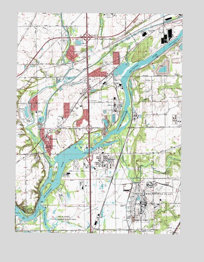
Channahon, IL USGS Topographic Map
Click on map above to begin viewing in our Map Viewer.

This topographic map contains these locations and features:
Feature Name Type Latitude Longitude GNIS ID View Map
Abraham Lincoln National CemeteryCemeteryN41.3917°W88.1304°1952199View Map
Aero Four AirportAirportN41.4361°W88.2487°427130View Map
BirdsPopulated PlaceN41.4750°W88.1973°422465View Map
BlodgettPopulated PlaceN41.3775°W88.1901°422475View Map
Bluff ParkParkN41.4350°W88.2015°1736576View Map
Caterpillar Fire DepartmentBuildingN41.4895°W88.1344°2682302View Map
Cedar CreekStreamN41.4434°W88.1642°405742View Map
Central ParkParkN41.4381°W88.2167°1736586View Map
ChannahonPopulated PlaceN41.4295°W88.2287°405955View Map
Channahon Fire Protection District Station 1BuildingN41.4296°W88.2232°2681939View Map
Channahon Fire Protection District Station 2BuildingN41.4710°W88.1806°2682497View Map
Channahon Junior High SchoolSchoolN41.4436°W88.2345°1736588View Map
Channahon Middle SchoolSchoolN41.4295°W88.2273°1822301View Map
Channahon Parkway State ParkParkN41.4242°W88.2276°1736589View Map
Channahon Post OfficePost OfficeN41.4338°W88.2232°1822300View Map
Channahon Village HallBuildingN41.4464°W88.2053°2037649View Map
Channanhon Police DepartmentBuildingN41.4369°W88.2201°2756963View Map
Chicago Glider Club GliderportAirportN41.4320°W88.2473°427131View Map
Conroy IslandIslandN41.4000°W88.2265°1822302View Map
Crown Trygg Industrial ParkLocaleN41.4872°W88.1372°2355469View Map
Des Plaines State Conservation AreaParkN41.3934°W88.2101°407146View Map
Des Plaines Wildlife HeadquartersLocaleN41.4139°W88.1978°407147View Map
DrummondPopulated PlaceN41.4059°W88.1767°422636View Map
Dupage Feeder (historical)CanalN41.4611°W88.2142°1802370View Map
DuPage RiverStreamN41.4156°W88.2195°407441View Map
Engelsman School (historical)SchoolN41.4920°W88.2353°1802372View Map
Exxon Mobil Oil Corporation Fire StationBuildingN41.4139°W88.1930°2682402View Map
Flint Hills Resources Fire StationBuildingN41.4493°W88.1752°2682610View Map
Frontage Road PondReservoirN41.3784°W88.1953°1822304View Map
Grant CreekStreamN41.3775°W88.2237°409288View Map
Grant Creek Cut-OffStreamN41.3895°W88.2309°409289View Map
Gravel Bank Station (historical)LocaleN41.4036°W88.1778°1822233View Map
Hadley Seed FarmLocaleN41.3925°W88.2325°2634765View Map
Haley Field (historical)AirportN41.4931°W88.2015°427408View Map
Interchange 245CrossingN41.4167°W88.1939°1822344View Map
Interchange 247CrossingN41.4348°W88.1945°1736650View Map
Interchange 248CrossingN41.4561°W88.1956°1736651View Map
Interchange 250CrossingN41.4867°W88.1970°1736652View Map
Jackson CreekStreamN41.4320°W88.1723°410999View Map
Kankakee Cut-OffStreamN41.3764°W88.2240°411302View Map
Lake of the WoodsPopulated PlaceN41.4897°W88.2081°2355770View Map
Link School (historical)SchoolN41.4709°W88.2206°1802371View Map
Lock Number 6DamN41.4231°W88.2290°2037675View Map
Lock Number 7DamN41.4209°W88.2287°2037676View Map
M G T Channahon Illinois HeliportAirportN41.4489°W88.1439°427132View Map
Maple Hill CemeteryCemeteryN41.4069°W88.1287°1952297View Map
McCune CemeteryCemeteryN41.4071°W88.1584°1952292View Map
McKinley Woods County Forest PreserveParkN41.3900°W88.2348°1736699View Map
MillsdalePopulated PlaceN41.4350°W88.1642°422983View Map
Minooka Widewater (historical)LakeN41.4484°W88.2273°1802369View Map
Moose IslandIslandN41.4103°W88.2198°413798View Map
N B Galloway Elementary SchoolSchoolN41.4403°W88.2148°1736615View Map
Oak LanePopulated PlaceN41.4792°W88.1997°2355771View Map
Red Brick School (historical)SchoolN41.4903°W88.1664°1802375View Map
Reed's Grove CemeteryCemeteryN41.3848°W88.1333°1952351View Map
Reeds Grove School (historical)SchoolN41.3920°W88.1301°1802377View Map
Riley School (historical)SchoolN41.3759°W88.2231°1802368View Map
Rock RunStreamN41.4792°W88.1801°416828View Map
Rock Run Business ParkLocaleN41.4919°W88.1728°2355456View Map
Rock Run ParkPopulated PlaceN41.4803°W88.1792°1802374View Map
Rock Run School (historical)SchoolN41.4653°W88.1795°1802373View Map
School Number 51 (historical)SchoolN41.4059°W88.1539°1802376View Map
Schweizer School (historical)SchoolN41.4642°W88.1509°1736741View Map
Smith BridgeBridgeN41.4220°W88.1945°425497View Map
Southfield Business ParkLocaleN41.4961°W88.1661°2355457View Map
Three Rivers MarinaLocaleN41.3895°W88.2287°1822303View Map
Township of ChannahonCivilN41.4203°W88.1935°428789View Map
Treat IslandIslandN41.4384°W88.1689°419826View Map
Troutman Grove CemeteryCemeteryN41.4526°W88.1273°419895View Map
Village of ElwoodCivilN41.4071°W88.1273°2398822View Map
WCCQ-FM (Crest Hill)TowerN41.4653°W88.1259°428175View Map
Willard Grove CemeteryCemeteryN41.4412°W88.2334°421182View Map

Note: Coordinates in the location and feature list above are referenced to NAD83 datum.


Copyright (C) 2008-2024 Ryan Niemi / Sunset Dynamics ... All Rights Reserved