TopoQuest Logo
Do you find TopoQuest useful?
Help keep TopoQuest running and adding new maps/features by donating!
Bitcoin:  19c7KJd3qBynnjoSw5npx9KScwjBe4ifkT
Litecoin:  LXs6TkuXGGXo1vDsWCkWVdjQX94eUKd6ui
Home View Maps Find Maps Find Places Resources & Links


Cedar Creek, Tennessee Topographic Map

USGS Map Title: Cedar Creek, TN
USGS Map MRC: 36082A8
DRG (GeoTIFF) Download: o36082a8.tif


Neighboring USGS Topographic Map Quads:


  Mohawk, TN  
36083B1
 

  Mosheim, TN  
36082B8
 

  Greeneville, TN  
36082B7
 

  Parrottsville, TN  
36083A1
 

  Cedar Creek, TN  
36082A8
 

  Davy Crockett Lake, TN  
36082A7
 

  Neddy Mountain, TN  
35083H1
 

  Paint Rock, NC  
35082H8
 

  Hot Springs, NC  
35082H7


Map MRC Location:

N37°
W83°
N37°
W82°
H8 H7 H6 H5 H4 H3 H2 H1
G8 G7 G6 G5 G4 G3 G2 G1
F8 F7 F6 F5 F4 F3 F2 F1
E8 E7 E6 E5 E4 E3 E2 E1
D8 D7 D6 D5 D4 D3 D2 D1
C8 C7 C6 C5 C4 C3 C2 C1
B8 B7 B6 B5 B4 B3 B2 B1
A8 A7 A6 A5 A4 A3 A2 A1
N36°
W83°
N36°
W82°

Cedar Creek, TN USGS 1:24K Topographic Map Preview:
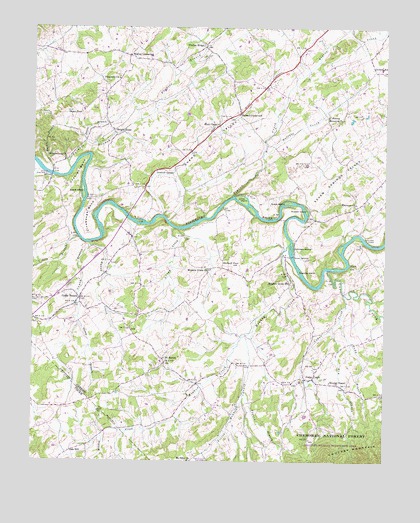
Cedar Creek, TN USGS Topographic Map
Click on map above to begin viewing in our Map Viewer.

This topographic map contains these locations and features:
Feature Name Type Latitude Longitude GNIS ID View Map
Allen BridgeBridgeN36.0593°W82.9079°1304801View Map
Allen ChapelChurchN36.0498°W82.8857°1275594View Map
Allenbridge (historical)Populated PlaceN36.0698°W82.8999°1649865View Map
Bales CreekStreamN36.0629°W82.9799°1276227View Map
Birdwell PondLakeN36.0568°W82.9277°1277520View Map
Bright HopePopulated PlaceN36.0954°W82.9713°1314732View Map
Bright Hope SchoolSchoolN36.0923°W82.9757°1278388View Map
Broyles ChapelChurchN36.0232°W82.8940°1278644View Map
Buffalo CreekStreamN36.0884°W82.9185°1278905View Map
Caney BranchPopulated PlaceN36.0468°W82.9832°1305668View Map
Caney BranchStreamN36.0615°W82.9796°1279556View Map
Caney Branch School (historical)SchoolN36.0440°W82.9807°1320058View Map
Caney Branch Volunteer Fire DepartmentBuildingN36.0551°W82.9802°2654637View Map
Cedar CreekStreamN36.0482°W82.8890°1280009View Map
Cedar CreekPopulated PlaceN36.0240°W82.9024°1305753View Map
Cedar Creek SchoolSchoolN36.0232°W82.9046°1309196View Map
Cedar Creek Volunteer Fire DepartmentBuildingN36.0244°W82.9023°2654874View Map
Cochran BendBendN36.0837°W82.9840°1280840View Map
Commissioner District 5CivilN36.0321°W82.8975°2464446View Map
Cove CreekStreamN36.0554°W82.8951°1327982View Map
Cove Creek ShoalsBarN36.0557°W82.8913°1643110View Map
DeBuskPopulated PlaceN36.1043°W82.8790°1647154View Map
DeBusk SchoolSchoolN36.1129°W82.8765°1306300View Map
Dikes Mill (historical)LocaleN36.0637°W82.9077°1643108View Map
Dikes ShoalsBarN36.0598°W82.9082°1643109View Map
Dodd BranchStreamN36.0407°W82.8910°1282549View Map
Dry BranchStreamN36.0382°W82.8940°1328079View Map
Dry BranchStreamN36.0648°W82.9840°1326808View Map
Easterly BridgeBridgeN36.0826°W82.9938°1283421View Map
Ebenezer ChurchChurchN36.0743°W82.8852°1283476View Map
Evans IslandIslandN36.0776°W82.9821°1283910View Map
Evans ValleyValleyN36.0710°W82.9539°1283914View Map
Farnsworth Ferry (historical)LocaleN36.0654°W82.8854°1643107View Map
Furness BranchStreamN36.0837°W82.9871°1285050View Map
Grays IslandIslandN36.0748°W82.9096°1286027View Map
Gregg CreekStreamN36.0670°W82.9502°1286234View Map
Harris BranchStreamN36.0826°W82.9927°1286945View Map
Hendersons ShoalsBarN36.0723°W82.9685°1643111View Map
Hogan PondLakeN36.1007°W82.9877°1287993View Map
Hunt ChapelChurchN36.0973°W82.9349°1288718View Map
Johnson IslandIslandN36.0618°W82.9079°1289636View Map
Jones IslandIslandN36.0757°W82.9257°1289811View Map
Jones Shed ChurchChurchN36.1184°W82.8790°1289820View Map
Linebaugh BendBendN36.0690°W82.9804°1291334View Map
Link HIlls Country ClubLocaleN36.0904°W82.8874°1309193View Map
Little Chucky (historical)Populated PlaceN36.1118°W82.9913°1309192View Map
Little Meadow CreekStreamN36.0379°W82.9218°1328734View Map
Long Creek Volunteer Fire DepartmentBuildingN36.0010°W82.9680°2654824View Map
Love BridgeBridgeN36.0687°W82.9629°1292116View Map
Loves Ferry (historical)LocaleN36.0690°W82.9624°1309194View Map
Luttrell SpringSpringN36.0837°W82.9563°1292317View Map
Meadow CreekStreamN36.0623°W82.9090°1328879View Map
Meadow Creek ChurchChurchN36.0551°W82.9379°1293500View Map
Meadow Creek MillLocaleN36.0512°W82.9077°1293501View Map
Mount Airy SchoolSchoolN36.0959°W82.8965°1294543View Map
Mount Olive CemeteryCemeteryN36.0007°W82.9438°1647975View Map
Mount Olive ChurchChurchN36.0001°W82.9438°1294707View Map
Nolichuckey Elementary SchoolSchoolN36.0412°W82.9377°1309195View Map
Oak Grove SchoolSchoolN36.0848°W82.9521°1296129View Map
Oak HillPopulated PlaceN36.0026°W82.9865°1315627View Map
Ore Bank SchoolSchoolN36.1170°W82.9821°1296480View Map
Orebank Volunteer Fire DepartmentBuildingN36.1163°W82.9815°2654636View Map
Pigeon BranchStreamN36.0209°W82.9251°1639449View Map
Pigeon CreekStreamN36.0765°W82.9290°1297438View Map
Pinegrove ChurchChurchN36.1101°W82.9699°1297595View Map
Privet BranchStreamN36.0918°W82.9815°1298552View Map
Pruitt Hill SchoolSchoolN36.0754°W82.8813°1298627View Map
Rabbit Hill SchoolSchoolN36.0012°W82.9793°1298773View Map
Rader Hill SchoolSchoolN36.0073°W82.9329°1298806View Map
Russell CrossroadPopulated PlaceN36.0998°W82.9274°1315851View Map
Russell IslandIslandN36.0720°W82.9032°1300341View Map
Saint JamesPopulated PlaceN36.0284°W82.9529°1300436View Map
Saint James ChurchChurchN36.0298°W82.9532°1647155View Map
Saint James Elementary SchoolSchoolN36.0287°W82.9540°1309197View Map
Saint James Volunteer Fire DepartmentBuildingN36.0314°W82.9555°2654635View Map
Seven Springs ValleyValleyN36.0745°W82.9013°1301103View Map
Sirenburg (historical)Populated PlaceN36.0193°W82.9788°1309198View Map
Southwest Nolichucky Division (historical)CensusN36.0168°W82.9057°1648724View Map
Speedwell ChurchChurchN36.0923°W82.9179°1270973View Map
Susong IslandIslandN36.0548°W82.9052°1271897View Map
Susong Memorial ChurchChurchN36.0995°W82.8954°1271898View Map
Timber RidgePopulated PlaceN36.1195°W82.9393°1304107View Map
Walker FordCrossingN36.0645°W82.8826°1314466View Map
Walker SchoolSchoolN36.0729°W82.8849°1304340View Map
Walter CrossroadPopulated PlaceN36.1168°W82.9665°1273747View Map
Whittenburg ChurchChurchN36.0868°W82.9893°1304572View Map

Note: Coordinates in the location and feature list above are referenced to NAD83 datum.


Copyright (C) 2008-2024 Ryan Niemi / Sunset Dynamics ... All Rights Reserved