TopoQuest Logo
Do you find TopoQuest useful?
Help keep TopoQuest running and adding new maps/features by donating!
Bitcoin:  19c7KJd3qBynnjoSw5npx9KScwjBe4ifkT
Litecoin:  LXs6TkuXGGXo1vDsWCkWVdjQX94eUKd6ui
Home View Maps Find Maps Find Places Resources & Links


Hermann, Missouri Topographic Map

USGS Map Title: Hermann, MO
USGS Map MRC: 38091F4
DRG (GeoTIFF) Download: o38091f4.tif


Neighboring USGS Topographic Map Quads:


  Americus, MO  
38091G5
 

  Pinnacle Lake, MO  
38091G4
 

  Jonesburg, MO  
38091G3
 

  Gasconade, MO  
38091F5
 

  Hermann, MO  
38091F4
 

  Berger, MO  
38091F3
 

  Pershing, MO  
38091E5
 

  Swiss, MO  
38091E4
 

  Dissen, MO  
38091E3


Map MRC Location:

N39°
W92°
N39°
W91°
H8 H7 H6 H5 H4 H3 H2 H1
G8 G7 G6 G5 G4 G3 G2 G1
F8 F7 F6 F5 F4 F3 F2 F1
E8 E7 E6 E5 E4 E3 E2 E1
D8 D7 D6 D5 D4 D3 D2 D1
C8 C7 C6 C5 C4 C3 C2 C1
B8 B7 B6 B5 B4 B3 B2 B1
A8 A7 A6 A5 A4 A3 A2 A1
N38°
W92°
N38°
W91°

Hermann, MO USGS 1:24K Topographic Map Preview:
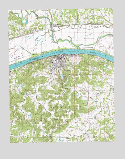
Hermann, MO USGS Topographic Map
Click on map above to begin viewing in our Map Viewer.

This topographic map contains these locations and features:
Feature Name Type Latitude Longitude GNIS ID View Map
A C Schneider LakeReservoirN38.6500°W91.4751°765335View Map
A C Schneider Lake DamDamN38.6500°W91.4752°765334View Map
Arthur Jasper LakeReservoirN38.6315°W91.4279°764512View Map
Beckman CemeteryCemeteryN38.6728°W91.4040°713845View Map
Benson LakeReservoirN38.6417°W91.4802°764508View Map
Benson Lake DamDamN38.6417°W91.4802°764507View Map
Bethel Church (historical)ChurchN38.7442°W91.3988°747933View Map
BridgeportPopulated PlaceN38.7437°W91.3999°730364View Map
Bridgeport CemeteryCemeteryN38.7367°W91.3996°730367View Map
Bridgeport LandingLocaleN38.7348°W91.4010°730366View Map
Case School (historical)SchoolN38.7423°W91.3890°747934View Map
City of HermannCivilN38.6983°W91.4342°2394360View Map
Cole CreekStreamN38.6950°W91.4921°716100View Map
Coles Creek School (historical)SchoolN38.6598°W91.4982°744175View Map
Curtis Vohs LakeReservoirN38.6950°W91.3818°764516View Map
Denuser CemeteryCemeteryN38.6623°W91.3963°716842View Map
Doctor Henson Lake DamDamN38.6967°W91.4518°765342View Map
Eberlin CemeteryCemeteryN38.6753°W91.4299°717387View Map
Elsenraat Lake DamDamN38.7284°W91.4902°765332View Map
Epple Lake DamDamN38.6350°W91.4602°765336View Map
Frene CreekStreamN38.7075°W91.4293°729493View Map
Frene School (historical)SchoolN38.6698°W91.4541°744173View Map
Gasconade County Sheriff's OfficeBuildingN38.7073°W91.4361°2752380View Map
Gehrke Lake DamDamN38.6684°W91.4185°765145View Map
Gouldner Lake DamDamN38.6950°W91.3818°764515View Map
Grass CemeteryCemeteryN38.6786°W91.4693°718715View Map
Grebe CemeteryCemeteryN38.6439°W91.4079°718774View Map
Grebe Lake DamDamN38.6550°W91.4285°765339View Map
Henson LakeReservoirN38.6964°W91.4523°765343View Map
HermannPopulated PlaceN38.7042°W91.4374°719397View Map
Hermann Area District HospitalHospitalN38.6931°W91.4496°2655051View Map
Hermann Area Hospital HeliportAirportN38.6928°W91.4513°758715View Map
Hermann CemeteryCemeteryN38.6992°W91.4351°2702140View Map
Hermann Country ClubLocaleN38.7495°W91.4546°755207View Map
Hermann Fire Company 1 Station 1BuildingN38.6960°W91.4419°2620287View Map
Hermann Fire Company 1 Station 2BuildingN38.7056°W91.4343°2621298View Map
Hermann Municipal AirportAirportN38.7056°W91.4915°758714View Map
Hermann Police DepartmentBuildingN38.6915°W91.4495°2752444View Map
Hermann Post OfficePost OfficeN38.6939°W91.4468°2782785View Map
Horstman CreekStreamN38.6612°W91.3910°719877View Map
Huffman CemeteryCemeteryN38.6695°W91.3929°719963View Map
Jasper Lake DamDamN38.6317°W91.4268°764511View Map
Jasper Lake DamDamN38.6267°W91.4402°765337View Map
Kallmeyers BluffCliffN38.7070°W91.4243°720467View Map
Karl Lake DamDamN38.7384°W91.4135°765333View Map
Keiser Lake DamDamN38.6784°W91.4485°765341View Map
Kemper CemeteryCemeteryN38.6575°W91.4882°720530View Map
Koeller CemeteryCemeteryN38.6325°W91.4093°720681View Map
Langendoerfer CemeteryCemeteryN38.6459°W91.4479°720807View Map
Little Berger CemeteryCemeteryN38.6289°W91.4010°721154View Map
Loutre Island ChurchChurchN38.7409°W91.4046°735705View Map
Loutre Island School (historical)SchoolN38.7198°W91.4091°730365View Map
Loutre RiverStreamN38.7120°W91.4174°729545View Map
Lower Little Berger School (historical)SchoolN38.6598°W91.3954°744363View Map
McGirk IslandAreaN38.7056°W91.4874°722116View Map
McKittrickPopulated PlaceN38.7350°W91.4438°722150View Map
Mueller Lake DamDamN38.6800°W91.4418°765340View Map
Nagelin CemeteryCemeteryN38.6636°W91.4840°723107View Map
Oak Haven CemeteryCemeteryN38.6309°W91.4543°723614View Map
Old Saint George CemeteryCemeteryN38.6917°W91.4318°723781View Map
Ott CemeteryCemeteryN38.6295°W91.4907°723873View Map
Peace Valley School (historical)SchoolN38.6956°W91.3968°744176View Map
Poeschel CemeteryCemeteryN38.6934°W91.4707°724686View Map
Ponticello Lake DamDamN38.6267°W91.3935°765338View Map
Quick CreekStreamN38.7098°W91.4521°725024View Map
RhinelandAreaN38.7167°W91.4168°760189View Map
Ruediger CemeteryCemeteryN38.6470°W91.4057°725658View Map
Saint George CemeteryCemeteryN38.7055°W91.4461°725751View Map
Saint Josephs ChurchChurchN38.6287°W91.4324°725809View Map
See Tal LakeReservoirN38.6874°W91.4359°726183View Map
See Tal Lake DamDamN38.6884°W91.4371°764509View Map
Smitt CemeteryCemeteryN38.6411°W91.4652°726641View Map
Tinermeyer CemeteryCemeteryN38.6584°W91.3965°727671View Map
Town of McKittrickCivilN38.7357°W91.4449°2396745View Map
Township of RoarkCivilN38.6450°W91.4501°766662View Map
Upper Little Berger SchoolSchoolN38.6273°W91.3974°744364View Map
Walkenbach Lake North DamDamN38.6785°W91.4845°765345View Map
Walkenbach Lake South DamDamN38.6767°W91.4868°765344View Map
Wohltman Lake DamDamN38.7284°W91.4718°765331View Map

Note: Coordinates in the location and feature list above are referenced to NAD83 datum.


Copyright (C) 2008-2024 Ryan Niemi / Sunset Dynamics ... All Rights Reserved