TopoQuest Logo
Do you find TopoQuest useful?
Help keep TopoQuest running and adding new maps/features by donating!
Bitcoin:  19c7KJd3qBynnjoSw5npx9KScwjBe4ifkT
Litecoin:  LXs6TkuXGGXo1vDsWCkWVdjQX94eUKd6ui
Home View Maps Find Maps Find Places Resources & Links


Carlisle, South Carolina Topographic Map

USGS Map Title: Carlisle, SC
USGS Map MRC: 34081E4
DRG (GeoTIFF) Download: o34081e4.tif


Neighboring USGS Topographic Map Quads:


  Union East, SC  
34081F5
 

  Leeds, SC  
34081F4
 

  Baton Rouge, SC  
34081F3
 

  Whitmire North, SC  
34081E5
 

  Carlisle, SC  
34081E4
 

  Carlisle SE, SC  
34081E3
 

  Whitmire South, SC  
34081D5
 

  Blair, SC  
34081D4
 

  Salem Crossroads, SC  
34081D3


Map MRC Location:

N35°
W82°
N35°
W81°
H8 H7 H6 H5 H4 H3 H2 H1
G8 G7 G6 G5 G4 G3 G2 G1
F8 F7 F6 F5 F4 F3 F2 F1
E8 E7 E6 E5 E4 E3 E2 E1
D8 D7 D6 D5 D4 D3 D2 D1
C8 C7 C6 C5 C4 C3 C2 C1
B8 B7 B6 B5 B4 B3 B2 B1
A8 A7 A6 A5 A4 A3 A2 A1
N34°
W82°
N34°
W81°

Carlisle, SC USGS 1:24K Topographic Map Preview:
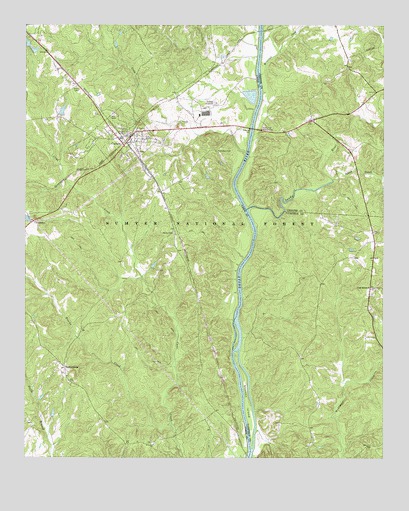
Carlisle, SC USGS Topographic Map
Click on map above to begin viewing in our Map Viewer.

This topographic map contains these locations and features:
Feature Name Type Latitude Longitude GNIS ID View Map
Brocks CreekStreamN34.5099°W81.4487°1229459View Map
CarlislePopulated PlaceN34.5929°W81.4626°1247163View Map
Carlisle DivisionCivilN34.6019°W81.4949°1938219View Map
Carlisle Fire DepartmentBuildingN34.5931°W81.4674°2578587View Map
Cool BranchPopulated PlaceN34.5493°W81.3795°1229586View Map
Cool BranchStreamN34.5696°W81.4112°1252227View Map
Cool Branch Baptist ChurchChurchN34.5493°W81.3782°1237002View Map
Cool Branch CemeteryCemeteryN34.5490°W81.3773°1237003View Map
Cool Branch ChurchChurchN34.5493°W81.3784°1252004View Map
Coxs CreekStreamN34.5876°W81.4229°1229602View Map
Fish Dam Battleground MonumentParkN34.5951°W81.4176°1230681View Map
Fish Dam CemeteryCemeteryN34.5887°W81.4329°1247751View Map
Fishdam Ferry (historical)CrossingN34.5974°W81.4201°1230682View Map
Fishdam FordCrossingN34.5954°W81.4207°1251648View Map
Glovers BranchStreamN34.5349°W81.4240°1252228View Map
Gus Jeter LakeReservoirN34.6180°W81.4975°1239521View Map
Gus Jeter Lake Dam D-2159DamN34.6185°W81.4982°1239520View Map
Hamilton School (historical)SchoolN34.5043°W81.4640°1232922View Map
HerbertLocaleN34.5107°W81.4370°1252019View Map
HerbertPopulated PlaceN34.5032°W81.4240°1232930View Map
Herbert Hunt CampLocaleN34.5735°W81.4590°1230602View Map
High Hill CreekStreamN34.5132°W81.4198°1252229View Map
Hill CemeteryCemeteryN34.5993°W81.4690°1229799View Map
Jeters Chapel School (historical)SchoolN34.5699°W81.4920°1232938View Map
Jeters PondReservoirN34.5693°W81.4998°1239517View Map
Jeters Pond Dam D-2157DamN34.5685°W81.4982°1239516View Map
Johns CreekStreamN34.5804°W81.3923°1229867View Map
Kelly Chapel (historical)ChurchN34.5654°W81.4482°1232947View Map
Kellys CemeteryCemeteryN34.5651°W81.4479°1246229View Map
Leeds Fire DepartmentBuildingN34.6035°W81.3801°2578238View Map
Mineral CreekStreamN34.6110°W81.4176°1246691View Map
Pride (historical)Populated PlaceN34.6140°W81.4315°1233008View Map
Saint Lukes ChurchChurchN34.5040°W81.4551°1230273View Map
Salinas PondReservoirN34.6002°W81.4871°1239523View Map
Salinas Pond Dam D-2610DamN34.6001°W81.4882°1239522View Map
Sandy RiverStreamN34.5721°W81.4223°1230298View Map
Shelton IslandIslandN34.5171°W81.4223°1250856View Map
Sims Chapel School (historical)SchoolN34.5513°W81.4548°1233042View Map
Smiths Ferry (historical)CrossingN34.5618°W81.4204°1251726View Map
South Sandy Boat RampLocaleN34.5726°W81.4220°1252018View Map
Town of CarlisleCivilN34.5920°W81.4645°2405379View Map
TuckertownPopulated PlaceN34.5263°W81.4859°1251224View Map

Note: Coordinates in the location and feature list above are referenced to NAD83 datum.


Copyright (C) 2008-2024 Ryan Niemi / Sunset Dynamics ... All Rights Reserved