TopoQuest Logo
Do you find TopoQuest useful?
Help keep TopoQuest running and adding new maps/features by donating!
Bitcoin:  19c7KJd3qBynnjoSw5npx9KScwjBe4ifkT
Litecoin:  LXs6TkuXGGXo1vDsWCkWVdjQX94eUKd6ui
Home View Maps Find Maps Find Places Resources & Links


Illahee Rock, Oregon Topographic Map

USGS Map Title: Illahee Rock, OR
USGS Map MRC: 43122C5
DRG (GeoTIFF) Download: o43122c5.tif


Neighboring USGS Topographic Map Quads:


  Chilcoot Mountain, OR  
43122D6
 

  Reynolds Ridge, OR  
43122D5
 

  Staley Ridge, OR  
43122D4
 

  Steamboat, OR  
43122C6
 

  Illahee Rock, OR  
43122C5
 

  Toketee Falls, OR  
43122C4
 

  Quartz Mountain, OR  
43122B6
 

  Twin Lakes Mountain, OR  
43122B5
 

  Fish Creek Desert, OR  
43122B4


Map MRC Location:

N44°
W123°
N44°
W122°
H8 H7 H6 H5 H4 H3 H2 H1
G8 G7 G6 G5 G4 G3 G2 G1
F8 F7 F6 F5 F4 F3 F2 F1
E8 E7 E6 E5 E4 E3 E2 E1
D8 D7 D6 D5 D4 D3 D2 D1
C8 C7 C6 C5 C4 C3 C2 C1
B8 B7 B6 B5 B4 B3 B2 B1
A8 A7 A6 A5 A4 A3 A2 A1
N43°
W123°
N43°
W122°

Illahee Rock, OR USGS 1:24K Topographic Map Preview:
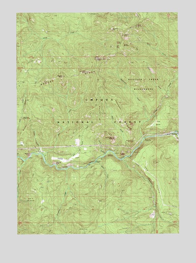
Illahee Rock, OR USGS Topographic Map
Click on map above to begin viewing in our Map Viewer.

This topographic map contains these locations and features:
Feature Name Type Latitude Longitude GNIS ID View Map
Bartrums RockSummitN43.3415°W122.5733°1158117View Map
Bear PointRidgeN43.3546°W122.5473°1137737View Map
Boulder CreekStreamN43.3037°W122.5287°1138473View Map
Boulder Flat Recreation SiteLocaleN43.3054°W122.5262°1155271View Map
Bradley RidgeRidgeN43.3154°W122.6117°1138564View Map
Calf CreekStreamN43.2912°W122.6200°1139152View Map
Charcoal PointCapeN43.2868°W122.5923°1139573View Map
Collins CampLocaleN43.3385°W122.5834°1140001View Map
Copeland CreekStreamN43.2915°W122.5453°1140093View Map
Dark CanyonValleyN43.2960°W122.5587°1140625View Map
Deception CreekStreamN43.2868°W122.5873°1140773View Map
Deception WayTrailN43.2768°W122.5887°1140777View Map
Devils StairwayCliffN43.3648°W122.5298°1140976View Map
Dry CreekStreamN43.2940°W122.6056°1141273View Map
Dry Creek CabinLocaleN43.2957°W122.6045°1141314View Map
Dry Gulch CreekStreamN43.2968°W122.5973°1141336View Map
Eagle CreekStreamN43.2965°W122.5364°1141466View Map
Eagle RidgeRidgeN43.3123°W122.5612°1141489View Map
Eagle RockSummitN43.2947°W122.5455°1141490View Map
Eagle Rock Recreation SiteLocaleN43.2957°W122.5539°1155270View Map
Happy CreekStreamN43.2957°W122.6073°1143278View Map
Harding ButteSummitN43.3619°W122.5430°1143298View Map
Hole in the GroundFlatN43.2729°W122.6206°1143657View Map
Horse PrairieFlatN43.3740°W122.5328°1143781View Map
Illahee FlatsFlatN43.2929°W122.5887°1135472View Map
Illahee Guard StationLocaleN43.2962°W122.5775°1143990View Map
Illahee RockPillarN43.3490°W122.5631°1143991View Map
Illahee SpringSpringN43.3568°W122.5453°1143992View Map
Little Oak FlatFlatN43.2840°W122.5731°1145217View Map
Marsters BridgeBridgeN43.2910°W122.5650°1135471View Map
North Umpqua DivisionCivilN43.2966°W122.6078°1938080View Map
Oak Flat LookoutLocaleN43.2898°W122.5195°1147111View Map
Oak FlatsFlatN43.2848°W122.5253°1147113View Map
Old Man RockPillarN43.3022°W122.5378°1147203View Map
Onion CreekStreamN43.3296°W122.5089°1147231View Map
Panther LeapCliffN43.2954°W122.6167°1125168View Map
Pine BenchBenchN43.3104°W122.5170°1125383View Map
Pine PointSummitN43.3122°W122.5619°1132927View Map
Quartz PointSummitN43.3732°W122.5970°1132928View Map
Ragged ButteSummitN43.3389°W122.5910°1125773View Map
Rattlesnake CreekStreamN43.3140°W122.5234°1125828View Map
Rattlesnake RidgeRidgeN43.3190°W122.5459°1125838View Map
Rattlesnake RockPillarN43.3040°W122.5526°1125840View Map
Snuff ShelterLocaleN43.2598°W122.5153°1127173View Map
Soda Springs Power PlantBuildingN43.3065°W122.5017°1135470View Map
Spring MountainSummitN43.3562°W122.5435°1136775View Map
Spring Mountain WayTrailN43.3462°W122.5195°1127453View Map
Weeping Rock CampgroundLocaleN43.2901°W122.5637°1132926View Map
Weeping Rock Campground Boat LaunchLocaleN43.2908°W122.5651°2668540View Map
Wild Rose CampLocaleN43.3648°W122.5403°1129050View Map
Wild Rose PointSummitN43.3652°W122.5518°1129051View Map
Wilson CreekStreamN43.2912°W122.5642°1129189View Map

Note: Coordinates in the location and feature list above are referenced to NAD83 datum.


Copyright (C) 2008-2024 Ryan Niemi / Sunset Dynamics ... All Rights Reserved